Category:Chodov (Prague)
Neighbourhood in Prague  | |||||
| Upload media | |||||
| Instance of | |||||
|---|---|---|---|---|---|
| Location | Prague 11, Prague 4, Prague, Czechia | ||||
| Inception |
| ||||
| Population |
| ||||
| Area |
| ||||
 | |||||
English: Chodov is a district in Prague, located southeast of city centre. With housing estates like Opatov, Litochleby or Roztyly it constitutes major part of so called Jižní Město or Praha 11. Chodov borders Michle in the west, Záběhlice (including Spořilov and Zahradní Město) in the north, Hostivař in the northeast and Háje in the east (Brechtova, Květnového vítězství, Prašná, U Modré školy, and Novomeského streets being the dividing line). Újezd is the next neighbouring district in the southeast (Kateřinky housing estate already belongs to Újezd), Šeberov and Kunratice borders Chodov in the south. Thus images of Jižní Město except Háje belong here.
Subcategories
This category has the following 24 subcategories, out of 24 total.
- Chodov at night (40 F)
C
E
H
- History of Chodov (Prague) (2 F)
J
L
N
P
R
S
T
V
- Views of Chodov (Prague) (5 F)
W
- Winter in Chodov (Prague) (6 F)
Media in category "Chodov (Prague)"
The following 11 files are in this category, out of 11 total.
-
 Area of Prague Eye Towers skyscrapers in Chodov (Prague).jpg 5,225 × 3,428; 7.94 MB
-
 Area of the former footbridge at the Medicentum in Chodov (Prague).jpg 5,209 × 3,365; 8.92 MB
-
 Centrum Chodov surrounding after reconstruction and extension 1.jpg 3,418 × 2,562; 2.09 MB
-
 Centrum Chodov surrounding after reconstruction and extension 3.jpg 4,032 × 3,024; 3.38 MB
-
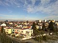
 Chodov - panoramio (1).jpg 1,944 × 2,592; 796 KB
-
 Chodov - panoramio.jpg 2,592 × 1,944; 865 KB
-
 Chodov 3.jpg 4,000 × 3,000; 3.85 MB
-
 Litochleby s okolím.jpg 840 × 469; 127 KB
-
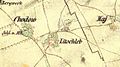
 Litochleby, 2. vojenské mapování.jpg 356 × 289; 35 KB
-
 Modern Trees in Fullmoon - Les antén za úplňku - panoramio.jpg 4,752 × 3,168; 3.05 MB
-
 Észrevett. - panoramio.jpg 1,933 × 1,463; 759 KB
.jpg)
.jpg)


.jpg)


