Category:Church of Solwerd
| Object location | | View all coordinates using: OpenStreetMap |
|---|
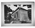
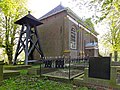
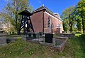
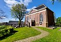
church building in Appingedam, Netherlands  | |||||
| Upload media | |||||
| Instance of | |||||
|---|---|---|---|---|---|
| Location | Solwerd, Appingedam, Eemsdelta, Groningen, Netherlands | ||||
| Street address |
| ||||
| Heritage designation |
| ||||
| Inception |
| ||||
| official website | |||||
 | |||||
|
This is a category about rijksmonument number 8256
|
| Address |
|
Media in category "Church of Solwerd"
The following 21 files are in this category, out of 21 total.
-
 Aanzicht - Solwerd - 20202476 - RCE.jpg 1,200 × 958; 186 KB
-
 Aanzicht - Solwerd - 20202477 - RCE.jpg 958 × 1,200; 190 KB
-

-
 Exterieur - Solwerd - 20202480 - RCE.jpg 1,200 × 958; 196 KB
-
 Exterieur - Solwerd - 20202481 - RCE.jpg 1,200 × 958; 189 KB
-
 Interieur naar het westen - Solwerd - 20202479 - RCE.jpg 1,200 × 862; 135 KB
-
 Interieur, aanzicht orgel, orgelnummer 1382 - Solwerd - 20370229 - RCE.jpg 876 × 1,200; 137 KB
-
 Kerk vanuit het zuid-oosten - Solwerd - 20202478 - RCE.jpg 1,200 × 850; 264 KB
-
 Kerk1 Solwerd.jpg 1,824 × 1,368; 934 KB
-
 Kerk2 Solwerd.jpg 1,824 × 1,368; 850 KB
-
 Overzicht noordoostgevel met kerkhof met klokkenstoel - Solwerd - 20364736 - RCE.jpg 1,176 × 1,200; 478 KB
-
 Overzicht noordwestgevel met kerkhof - Solwerd - 20364735 - RCE.jpg 1,176 × 1,200; 435 KB
-
 Overzicht zuidwestgevel met kerkhof - Solwerd - 20364737 - RCE.jpg 1,192 × 1,200; 402 KB
-
 Solwerd Klokkenstoel 9505.JPG 1,712 × 2,288; 2.2 MB
-
 Solwert, tsjerke.jpg 3,086 × 2,138; 3.32 MB
-
 Solwerter tsjerke, klokkestoel.jpg 2,245 × 2,244; 2.68 MB
-
 Solwerter tsjerke, kânsel.jpg 3,303 × 2,286; 1.72 MB
-
 Solwerter tsjerke, oargel.jpg 2,456 × 3,547; 2.09 MB
-
 Solwerter tsjerke.jpg 2,773 × 1,922; 2.59 MB
-
 Sowlerd, kerk.jpg 4,608 × 3,456; 3.4 MB
-


