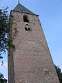
Category:Church tower of Oud-Leusden
| Object location | | View all coordinates using: OpenStreetMap |
|---|
 | |||||
| Upload media | |||||
| Instance of |
| ||||
|---|---|---|---|---|---|
| Location | Achterveld, Barneveld, Gelderland, Netherlands | ||||
| Street address |
| ||||
| Heritage designation |
| ||||
| Inception |
| ||||
 | |||||
|
This is a category about rijksmonument number 25790
|
| Address |
|
Media in category "Church tower of Oud-Leusden"
The following 21 files are in this category, out of 21 total.
-
 1729, reproductie kerk - Leusden - 20139148 - RCE.jpg 1,200 × 808; 231 KB
-
 Dorpsgezicht - Leusden - 20139117 - RCE.jpg 1,200 × 825; 220 KB
-

-
 Exterieur TOREN, OVERZICHT ZUIDGEVEL EN KERKHOFMUUR - Oud-Leusden - 20314161 - RCE.jpg 1,190 × 1,200; 432 KB
-

-
 Oud Leusden Kerktoren 1.jpg 2,365 × 3,395; 2.58 MB
-
 Oud Leusden Kerktoren 2.jpg 2,575 × 3,485; 4.16 MB
-
 Oud-Leusden-kerktoren (1).JPG 3,000 × 4,000; 10.15 MB
-
 Oud-Leusden-kerktoren (2).JPG 3,000 × 4,000; 4.11 MB
-
 Oud-Leusden-kerktoren (3).JPG 3,000 × 4,000; 4.39 MB
-
 Oude toren bij Begraafplaats - Leusden - 20139151 - RCE.jpg 964 × 1,200; 304 KB
-
 Pen en penseeltekening 1749 - Leusden - 20139142 - RCE.jpg 1,200 × 901; 268 KB
-
 Pen en penseeltekening door J.Hoorn 1784 - Leusden - 20139143 - RCE.jpg 1,200 × 946; 270 KB
-
 RM25790 Kerktoren Oud-Leusden.JPG 2,373 × 4,200; 1.91 MB
-
 Toren - Leusden - 20139144 - RCE.jpg 915 × 1,200; 303 KB
-
 Toren - Leusden - 20139145 - RCE.jpg 883 × 1,200; 260 KB
-
 Toren - Leusden - 20139146 - RCE.jpg 902 × 1,200; 270 KB
-
 WLM - Minke Wagenaar - 06-07-07 Historische Geografie 001.jpg 2,272 × 1,704; 1.74 MB
-
 WLM - Minke Wagenaar - 06-07-07 Historische Geografie 002.jpg 2,272 × 1,704; 1.76 MB
-
 WLM - Minke Wagenaar - 06-07-07 Historische Geografie 003.jpg 1,704 × 2,272; 1.42 MB
-
 WLM - Minke Wagenaar - 06-07-07 Historische Geografie 004.jpg 2,272 × 1,704; 1.52 MB


.JPG)
.JPG)
.JPG)


