Category:Churchill, Somerset
English: Churchill is a village and civil parish in Somerset, England. It is located in the unitary authority of North Somerset, on the western edge of the Mendip Hills about east of Weston-super-Mare.
village and civil parish in Somerset, England  | |||||
| Upload media | |||||
| Instance of | |||||
|---|---|---|---|---|---|
| Location | North Somerset, Somerset, South West England, England | ||||
 | |||||
Subcategories
This category has the following 6 subcategories, out of 6 total.
Media in category "Churchill, Somerset"
The following 126 files are in this category, out of 126 total.
-
 A bend in Bath Road (A368) - geograph.org.uk - 4251797.jpg 640 × 480; 83 KB
-
 A field on Green Hill - geograph.org.uk - 2636802.jpg 2,592 × 1,944; 1.63 MB
-
 A38 heading east - geograph.org.uk - 4251806.jpg 640 × 480; 71 KB
-

-
 B3133 at Stock - geograph.org.uk - 2419170.jpg 640 × 406; 63 KB
-
 Bomb damage - geograph.org.uk - 5609188.jpg 3,648 × 2,432; 4.5 MB
-
 Bridleway to Upper Langford - geograph.org.uk - 2560640.jpg 480 × 640; 157 KB
-
 Bus Shelter, Churchill - geograph.org.uk - 1801892.jpg 640 × 497; 126 KB
-
 Churchill clock tower - geograph.org.uk - 5938622.jpg 1,024 × 778; 180 KB
-
 Churchill Gate - geograph.org.uk - 5572030.jpg 1,280 × 960; 235 KB
-
 Churchill Green church - geograph.org.uk - 4985859.jpg 1,024 × 768; 197 KB
-
 Churchill Methodist Church - geograph.org.uk - 5938945.jpg 1,024 × 772; 159 KB
-
 Churchill Millennium stone.jpg 3,296 × 2,472; 4.28 MB
-
 Churchill Post Office and Stores - geograph.org.uk - 5938954.jpg 1,024 × 798; 159 KB
-
 Churchill Rhyne - geograph.org.uk - 5062078.jpg 2,617 × 1,726; 1.25 MB
-
 Churchill Rhyne - geograph.org.uk - 5062082.jpg 2,038 × 2,670; 1.11 MB
-
 Churchill Telephone Exchange - geograph.org.uk - 668105.jpg 640 × 480; 57 KB
-
 Churchillsomerset.JPG 2,848 × 2,136; 1.24 MB
-
 Cottage on Doleber Row - geograph.org.uk - 2723226.jpg 3,264 × 2,448; 4.55 MB
-
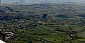 Country around Churchill from the air - geograph.org.uk - 5483536.jpg 1,630 × 833; 327 KB
-
 Dinghurst Road - geograph.org.uk - 4984113.jpg 1,024 × 768; 205 KB
-

-
 Doleber Row - geograph.org.uk - 2723238.jpg 3,264 × 2,448; 4.79 MB
-
 Doleberrow - geograph.org.uk - 1236570.jpg 640 × 427; 101 KB
-
 Dolebury - geograph.org.uk - 2561323.jpg 640 × 437; 97 KB
-
 Dolebury Warren nature reserve - geograph.org.uk - 2721440.jpg 3,264 × 2,448; 4.86 MB
-
 Dolebury Warren nature reserve - geograph.org.uk - 2721463.jpg 3,264 × 2,448; 4.47 MB
-
 Entering Langford - geograph.org.uk - 4251804.jpg 640 × 480; 42 KB
-
 Entrance to Churchill Green church - geograph.org.uk - 4985863.jpg 800 × 600; 170 KB
-
 Esso, Budgens and Subway, Lower Langford - geograph.org.uk - 5122520.jpg 1,024 × 861; 176 KB
-
 Farmland at Stock - geograph.org.uk - 4985815.jpg 800 × 600; 112 KB
-
 Farmland, Lower Langford - geograph.org.uk - 3455981.jpg 640 × 480; 76 KB
-
 Field at Churchill Green - geograph.org.uk - 4985868.jpg 800 × 600; 184 KB
-
 Field by the B3133 - geograph.org.uk - 1745688.jpg 640 × 480; 98 KB
-
 Field entrance off Bath Road - geograph.org.uk - 3455968.jpg 640 × 480; 85 KB
-
 Field entrance off King Road - geograph.org.uk - 4984111.jpg 1,024 × 768; 205 KB
-
 Field near Churchill Green - geograph.org.uk - 2636783.jpg 2,592 × 1,944; 1.33 MB
-
 Field, Blackmoor - geograph.org.uk - 2419073.jpg 640 × 461; 81 KB
-
 Fields west of Churchill - geograph.org.uk - 2636792.jpg 2,592 × 1,944; 1.18 MB
-
 Finger Post - geograph.org.uk - 878610.jpg 640 × 480; 97 KB
-
 Flush Bracket OSBM G2256, Churchill, School - geograph.org.uk - 5572907.jpg 960 × 1,280; 393 KB
-
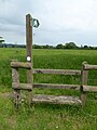
 Footpath and stile - geograph.org.uk - 4985809.jpg 800 × 600; 134 KB
-
 Front Street, Churchill - geograph.org.uk - 5938960.jpg 1,024 × 787; 217 KB
-
 Grazing, Churchill Batch - geograph.org.uk - 3455965.jpg 640 × 480; 66 KB
-
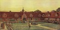 Illustration of Sidney Hill Cottage Homes.jpg 1,600 × 817; 424 KB
-
 Illustration of Sidney Hill Cottage Homes.png 1,411 × 746; 1.51 MB
-
 Inside St. Mary, Langford (b) - geograph.org.uk - 3157162.jpg 480 × 640; 75 KB
-
 Inside St. Mary, Langford (d) - geograph.org.uk - 3157172.jpg 480 × 640; 66 KB
-
 Inside St. Mary, Langford (e) - geograph.org.uk - 3157174.jpg 480 × 640; 69 KB
-
 Jubilee Clock Tower, Front Street, Churchill - geograph.org.uk - 5406858.jpg 3,456 × 5,184; 7.36 MB
-
 King Road - geograph.org.uk - 5938970.jpg 1,024 × 768; 309 KB
-
 Kingcups by the Strawberry Line - geograph.org.uk - 5062361.jpg 1,166 × 1,437; 711 KB
-
 Ladymead Lane - geograph.org.uk - 5122524.jpg 1,024 × 819; 178 KB
-
 Ladymead Lane, Churchill - geograph.org.uk - 3455971.jpg 640 × 480; 88 KB
-
 Langford Brook, Blackmoor - geograph.org.uk - 2419001.jpg 480 × 640; 80 KB
-
 Limestone Link - geograph.org.uk - 2721998.jpg 3,264 × 2,448; 4.36 MB
-
 Limestone Link near Hill Farm - geograph.org.uk - 2560628.jpg 480 × 640; 154 KB
-
 Lychgate, Churchill Green church - geograph.org.uk - 4985867.jpg 800 × 600; 133 KB
-
 Lyncombe Lane - geograph.org.uk - 1245687.jpg 640 × 427; 78 KB
-
 Matron's House at Sidney Hill Cottage Homes.jpg 3,006 × 1,877; 2.01 MB
-
 Mendip well maintained - geograph.org.uk - 1982832.jpg 778 × 519; 68 KB
-
 Methodist Church, Front Street, Churchill - geograph.org.uk - 5406849.jpg 4,999 × 2,988; 4.93 MB
-
 Murphy's Fish Bar, Churchill, Somerset (geograph 6388618 by Neil Owen).jpg 3,296 × 2,472; 3.48 MB
-
 New Road (A38) - geograph.org.uk - 4251793.jpg 640 × 480; 85 KB
-
 No argument^ - geograph.org.uk - 2721419.jpg 3,264 × 2,448; 4.73 MB
-

-

-

-
 On the A38 - geograph.org.uk - 4143040.jpg 4,000 × 2,664; 4.5 MB
-
 Ordnance Survey Cut Mark - geograph.org.uk - 4866039.jpg 480 × 640; 124 KB
-
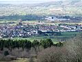
 Panorama of Churchill village taken from Windmill Hill.jpg 7,328 × 2,176; 7.68 MB
-
 Part of the former school at Churchill - geograph.org.uk - 5572913.jpg 960 × 1,280; 333 KB
-
 Paths to Dolebury - geograph.org.uk - 2561353.jpg 480 × 640; 154 KB
-
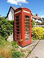 Red Telephone Kiosk in Churchill.jpg 3,024 × 4,032; 6.11 MB
-
 Saint Mary, Langford, September 2012 - geograph.org.uk - 3139375.jpg 640 × 480; 66 KB
-
 Sandmead Rhyne - geograph.org.uk - 5062544.jpg 3,072 × 2,048; 1.59 MB
-
-
 Seed Drilling at Lower Langford - geograph.org.uk - 1801884.jpg 640 × 480; 100 KB
-
 Sidney Hill Cottage Homes quadrangle.jpg 1,890 × 1,283; 636 KB
-
 Sidney Hill Cottage Homes, Churchill.jpg 3,024 × 4,032; 3.08 MB
-
 Sidney Hill Cottage Homes.jpg 3,024 × 4,032; 3.38 MB
-
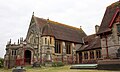
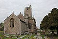 St John the Baptist Church, Church Lane, Churchill Green - geograph.org.uk - 5406834.jpg 5,184 × 3,456; 6.94 MB
-
 St John the Baptist Church, Churchill - geograph.org.uk - 5938965.jpg 1,024 × 768; 175 KB
-
 Stile and footpath - geograph.org.uk - 4985800.jpg 768 × 1,024; 249 KB
-
 Stile on Dolebury Warren - geograph.org.uk - 2561160.jpg 499 × 640; 110 KB
-
 Stock Lane - geograph.org.uk - 2419087.jpg 640 × 480; 83 KB
-
 Strawberry Line - geograph.org.uk - 5062094.jpg 1,920 × 1,280; 942 KB
-
 Strawberry Line - geograph.org.uk - 5062687.jpg 3,072 × 2,048; 1.3 MB
-
 Strawberry Line - geograph.org.uk - 5172316.jpg 1,600 × 1,067; 764 KB
-
 Strawberry Line approaching Droveway Bridge - geograph.org.uk - 4936589.jpg 2,883 × 1,787; 1.19 MB
-
 Strawberry Line at Sandmead Rhyne - geograph.org.uk - 5062676.jpg 3,072 × 2,048; 1.33 MB
-
 Strawberry Line at Sandmead Rhyne - geograph.org.uk - 5062701.jpg 3,056 × 2,005; 1.86 MB
-
 The Churchill Inn - geograph.org.uk - 5590779.jpg 1,024 × 774; 138 KB
-
 The Churchill pub, Langford - geograph.org.uk - 4251801.jpg 640 × 480; 50 KB
-
 The Crown Inn Churchill - geograph.org.uk - 1173349.jpg 640 × 480; 108 KB
-
 The Dolberry Building - geograph.org.uk - 5913161.jpg 1,780 × 2,046; 600 KB
-
 The Langford Inn - geograph.org.uk - 2803427.jpg 2,304 × 1,704; 1.44 MB
-
 The Stag and Hounds, Bristol Road - geograph.org.uk - 5122517.jpg 1,024 × 772; 133 KB
-
 The Stag ^ Hounds pub, Bristol Road - geograph.org.uk - 3455974.jpg 640 × 480; 55 KB
-
 The Tog Store - geograph.org.uk - 3377746.jpg 1,024 × 768; 113 KB
-

-

-

-

-

-

-

-

-

-

-

-

-

-

-

-

-

-
 Towards Hill Farm - geograph.org.uk - 2560643.jpg 640 × 464; 68 KB
-
 Track by the Strawberry Line - geograph.org.uk - 5062131.jpg 3,072 × 2,048; 1.31 MB
-
 Traffic on the A38 at Churchill - geograph.org.uk - 5460182.jpg 640 × 406; 121 KB
-
 Traffic queue on the A38 - geograph.org.uk - 5460179.jpg 640 × 440; 191 KB
-
 Tree in hedge near Yanel Farm - geograph.org.uk - 5062393.jpg 1,673 × 1,799; 897 KB
-
 Trees by the A38 - geograph.org.uk - 1826754.jpg 640 × 480; 110 KB
-
 Turning for Church Lane - geograph.org.uk - 5938951.jpg 1,024 × 794; 279 KB
-
 Victoria Jubilee Langford Homes - geograph.org.uk - 4985837.jpg 800 × 600; 136 KB
-
 View from Dolebury Warren - geograph.org.uk - 2561252.jpg 640 × 408; 88 KB
_-_geograph.org.uk_-_4251797.jpg)


.jpg)


_-_geograph.org.uk_-_3157162.jpg)
_-_geograph.org.uk_-_3157172.jpg)
_-_geograph.org.uk_-_3157174.jpg)


.jpg)
_-_geograph.org.uk_-_4251793.jpg)


_-_geograph.org.uk_-_3143196.jpg)
_-_geograph.org.uk_-_3143265.jpg)
_-_geograph.org.uk_-_3143270.jpg)
_-_geograph.org.uk_-_3143272.jpg)
_-_geograph.org.uk_-_3143280.jpg)
_-_geograph.org.uk_-_3143290.jpg)
_-_geograph.org.uk_-_3143293.jpg)
_-_geograph.org.uk_-_3143294.jpg)
_-_geograph.org.uk_-_3143296.jpg)
_-_geograph.org.uk_-_3143211.jpg)
_-_geograph.org.uk_-_3143215.jpg)
_-_geograph.org.uk_-_3143224.jpg)
_-_geograph.org.uk_-_3143239.jpg)
_-_geograph.org.uk_-_3143244.jpg)
_-_geograph.org.uk_-_3143247.jpg)
_-_geograph.org.uk_-_3143256.jpg)
_-_geograph.org.uk_-_3143259.jpg)


