Category:Coates, Gloucestershire
village and civil parish in Gloucestershire, UK | |||||
| Upload media | |||||
| Instance of | |||||
|---|---|---|---|---|---|
| Location | Cotswold, Gloucestershire, South West England, England | ||||
| Said to be the same as | Coates (Wikimedia duplicated page, civil parish) | ||||
 | |||||
English: Coates is a village situated in Gloucestershire, England. It is around 5 km or 3 miles west of Cirencester and close to Cirencester Park, part of the Bathurst Estate. It is the nearest village to the source of the river Thames at Thames Head, and it is close to the course of the Foss Way or Fosse Way, the ancient Roman road. The nearest railway station is Kemble.
Subcategories
This category has the following 6 subcategories, out of 6 total.
Media in category "Coates, Gloucestershire"
The following 200 files are in this category, out of 357 total.
(previous page) (next page)-
 "Stop, look, listen" crossing near Kemble - geograph.org.uk - 3028558.jpg 1,600 × 1,200; 719 KB
-
 1-6 Bathurst Row, Coates - geograph.org.uk - 4954525.jpg 3,264 × 2,448; 3.33 MB
-
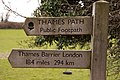 184 miles to the Barrier - geograph.org.uk - 3427490.jpg 1,500 × 1,000; 172 KB
-
 A wall across the Thames - geograph.org.uk - 3427516.jpg 1,500 × 1,000; 279 KB
-
 A419 at Two Mile Lodge - geograph.org.uk - 1955868.jpg 640 × 407; 95 KB
-
 Abandoned old plough - geograph.org.uk - 4812097.jpg 1,024 × 680; 384 KB
-
 Across the field - geograph.org.uk - 6058167.jpg 4,320 × 3,240; 3.18 MB
-
 Across the lines (1) - geograph.org.uk - 6058173.jpg 3,240 × 4,320; 7.1 MB
-
 Across the lines (2) - geograph.org.uk - 6058177.jpg 4,320 × 3,240; 6.39 MB
-
 Across the lines (3) - geograph.org.uk - 6058178.jpg 4,170 × 3,127; 5.17 MB
-
 Across Trewsbury Road - geograph.org.uk - 6006346.jpg 4,320 × 3,240; 4.37 MB
-
 Along the field edge - geograph.org.uk - 6006344.jpg 4,320 × 3,240; 4.08 MB
-
 Along the lane - geograph.org.uk - 6005025.jpg 4,320 × 3,240; 3.73 MB
-
 Approaching Thames Head - geograph.org.uk - 5345681.jpg 2,592 × 1,944; 1.84 MB
-
 Approaching the Tunnel House Inn - geograph.org.uk - 466025.jpg 640 × 477; 97 KB
-
 Arable field at Coates - geograph.org.uk - 3879854.jpg 1,024 × 680; 222 KB
-
 Arable land near Coates - geograph.org.uk - 3881100.jpg 1,024 × 680; 223 KB
-
 Arbor House - geograph.org.uk - 6103487.jpg 4,320 × 3,240; 3.14 MB
-
 Ashwell Pool - geograph.org.uk - 1234695.jpg 480 × 640; 144 KB
-
 Ashwell Pool - geograph.org.uk - 3921887.jpg 3,711 × 3,456; 4.89 MB
-
 Back in time - geograph.org.uk - 5221865.jpg 1,006 × 711; 306 KB
-
 Barn and churchyard, Coates - geograph.org.uk - 1517223.jpg 640 × 480; 240 KB
-
 Barn at Coatesfield Bridge - geograph.org.uk - 3921872.jpg 4,608 × 3,456; 6.24 MB
-
 Barn near Coatesfield Bridge - geograph.org.uk - 3921871.jpg 4,608 × 3,456; 6.22 MB
-
 Barn south of Coates - geograph.org.uk - 1234844.jpg 640 × 480; 103 KB
-
 Barn viewed from the Wysis Way - geograph.org.uk - 2378274.jpg 1,024 × 680; 193 KB
-
 Barn, Sheep Dip and Pens - geograph.org.uk - 3921587.jpg 4,608 × 2,416; 5.33 MB
-
 Beeches by the Monarch's Way - geograph.org.uk - 1234605.jpg 640 × 480; 113 KB
-
 Bledisloe (geograph 6003571).jpg 3,533 × 2,650; 1.78 MB
-
 Bledisloe House - geograph.org.uk - 3879861.jpg 1,024 × 680; 216 KB
-
 Bledisloe House from The Monarch's Way - geograph.org.uk - 3921889.jpg 4,310 × 2,638; 5.9 MB
-
 Booster pump - geograph.org.uk - 6103489.jpg 4,145 × 3,109; 3.45 MB
-
 Bordering on farcical (18) - geograph.org.uk - 4085876.jpg 640 × 480; 98 KB
-

-
 Bridge over the road to Tarlton - geograph.org.uk - 1595763.jpg 640 × 427; 76 KB
-
 Church Farm, Coates - geograph.org.uk - 1517793.jpg 640 × 479; 216 KB
-
 Coates church - geograph.org.uk - 3879843.jpg 1,024 × 680; 240 KB
-
 Coates church - geograph.org.uk - 3879850.jpg 1,024 × 680; 222 KB
-
 Coates church on the horizon - geograph.org.uk - 5458356.jpg 640 × 360; 60 KB
-
 Coates Manor Farm (1) - geograph.org.uk - 6004374.jpg 4,320 × 3,240; 2.07 MB
-
 Coates Manor Farm (10) - geograph.org.uk - 6004521.jpg 4,320 × 3,240; 4.66 MB
-
 Coates Manor Farm (11) - geograph.org.uk - 6004524.jpg 4,320 × 3,240; 5.22 MB
-
 Coates Manor Farm (12) - geograph.org.uk - 6004530.jpg 4,320 × 3,240; 2.77 MB
-
 Coates Manor Farm (13) - geograph.org.uk - 6005018.jpg 4,320 × 3,240; 2.6 MB
-
 Coates Manor Farm (14) - geograph.org.uk - 6005019.jpg 4,320 × 3,240; 3.76 MB
-
 Coates Manor Farm (15) - geograph.org.uk - 6005020.jpg 4,320 × 3,240; 3.18 MB
-
 Coates Manor Farm (2) - geograph.org.uk - 6004387.jpg 4,320 × 3,240; 3.85 MB
-
 Coates Manor Farm (3) - geograph.org.uk - 6004389.jpg 4,320 × 3,240; 3.49 MB
-
 Coates Manor Farm (4) - geograph.org.uk - 6004392.jpg 3,240 × 4,320; 3.03 MB
-
 Coates Manor Farm (5) - geograph.org.uk - 6004393.jpg 3,238 × 3,238; 1.57 MB
-
 Coates Manor Farm (6) - geograph.org.uk - 6004394.jpg 4,093 × 3,069; 2.82 MB
-
 Coates Manor Farm (7) - geograph.org.uk - 6004398.jpg 4,320 × 3,240; 3.67 MB
-
 Coates Manor Farm (8) - geograph.org.uk - 6004492.jpg 4,320 × 3,240; 5.05 MB
-
 Coates Manor Farm (9) - geograph.org.uk - 6004502.jpg 4,320 × 3,240; 4.55 MB
-
 Coates Roundhouse - geograph.org.uk - 1208043.jpg 640 × 480; 113 KB
-
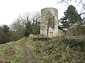 Coates Roundhouse - geograph.org.uk - 1208045.jpg 640 × 480; 91 KB
-
 Coates Roundhouse 2021.jpg 4,592 × 3,056; 8.47 MB
-
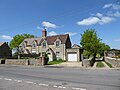
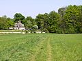
 Coates village - geograph.org.uk - 5086238.jpg 2,592 × 1,944; 1.74 MB
-
 Coates village hall - geograph.org.uk - 337226.jpg 640 × 497; 87 KB
-
 Coates war memorial - geograph.org.uk - 6006341.jpg 4,292 × 3,219; 2.72 MB
-
 Coates, source of the Thames - geograph.org.uk - 5627376.jpg 1,200 × 1,600; 873 KB
-
 Coatesfield Bridge - geograph.org.uk - 3921875.jpg 4,608 × 3,456; 6.01 MB
-
 Communications equipment - geograph.org.uk - 6004395.jpg 4,219 × 3,165; 4.05 MB
-
 Copse beyond a gate - South of Coates - geograph.org.uk - 3921869.jpg 4,399 × 3,116; 5.29 MB
-
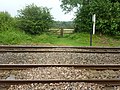
 Cotswold crossing-Coates, Glos - geograph.org.uk - 2871967.jpg 3,072 × 2,304; 2.33 MB
-
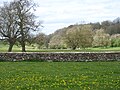
 Cotswold dry valley - geograph.org.uk - 1034649.jpg 640 × 480; 87 KB
-
 Course of Thames and Severn Canal - geograph.org.uk - 1206825.jpg 640 × 480; 106 KB
-

-
 Cross paths - geograph.org.uk - 6006343.jpg 4,320 × 3,240; 4.65 MB
-
 Culvert on Thames below the Fosse Way (1480).jpg 4,288 × 2,848; 6.23 MB
-

-
 Drive to Trewsbury Farm and House - geograph.org.uk - 3008298.jpg 640 × 480; 123 KB
-

-
 Electricity infrastructure - geograph.org.uk - 6006350.jpg 4,320 × 3,240; 3.65 MB
-
 Entrance to Bledisloe House - geograph.org.uk - 3879880.jpg 1,024 × 680; 308 KB
-
 Ex-GWR skew bridge - geograph.org.uk - 1208047.jpg 640 × 480; 114 KB
-
 Farm track and footpath - geograph.org.uk - 3881115.jpg 1,024 × 680; 219 KB
-
 Farmland east of Bledisloe House - geograph.org.uk - 3879864.jpg 1,024 × 680; 244 KB
-
 Farmland near Coates - geograph.org.uk - 3921581.jpg 4,608 × 3,456; 7.3 MB
-
 Father Thames, at Thames Head - geograph.org.uk - 3495487.jpg 640 × 480; 129 KB
-
 Field Barn Farm - geograph.org.uk - 3921893.jpg 4,608 × 3,456; 7.75 MB
-
 Field below the source of the Thames (1473).jpg 4,288 × 2,848; 6.71 MB
-
 Field below the source of the Thames (1474).jpg 4,288 × 2,848; 6.97 MB
-
 Field below the source of the Thames (1476).jpg 4,288 × 2,848; 6.71 MB
-
 Field below the source of the Thames (1477).jpg 4,288 × 2,848; 6.85 MB
-
 Field below the source of the Thames (1479).jpg 4,288 × 2,848; 6.42 MB
-
 Field below the source of the Thames (1491).jpg 4,288 × 2,848; 6.89 MB
-
 Field below the source of the Thames (1492).jpg 4,288 × 2,848; 6.29 MB
-
 Field near Thames Head, Gloucestershire - geograph.org.uk - 5445873.jpg 800 × 600; 110 KB
-
 Fields and woods west of Coates - geograph.org.uk - 5086249.jpg 2,592 × 1,944; 1.98 MB
-
 Fields by the Fosse Way - geograph.org.uk - 3007906.jpg 640 × 480; 46 KB
-
 Fields by the railway - geograph.org.uk - 3424640.jpg 1,500 × 1,000; 169 KB
-
 Fields in Gloucestershire - geograph.org.uk - 4082561.jpg 1,280 × 960; 937 KB
-
 Fields near Trewsbury House (1462).jpg 4,288 × 2,848; 6.78 MB
-
 Fields near Trewsbury House (1463).jpg 4,288 × 2,848; 6.35 MB
-
 Fields near Trewsbury House (1465).jpg 4,288 × 2,848; 6.3 MB
-
 Fields to west of Church Farm - geograph.org.uk - 4698377.jpg 800 × 425; 48 KB
-
 First gate on the Thames Path - geograph.org.uk - 3427447.jpg 1,500 × 1,000; 224 KB
-
 First water from the source of the Thames - geograph.org.uk - 300578.jpg 640 × 480; 112 KB
-

-

-
 Footpath across railway line near Bassett Dockem - geograph.org.uk - 4955328.jpg 3,264 × 2,448; 3.53 MB
-
 Footpath alongside railway line - geograph.org.uk - 4955369.jpg 4,000 × 3,000; 4.55 MB
-
 Footpath through Cirencester Park - geograph.org.uk - 1892724.jpg 1,500 × 996; 1.86 MB
-
 Former National School - geograph.org.uk - 3879873.jpg 1,024 × 680; 176 KB
-
 Former National School, Coates - geograph.org.uk - 3879877.jpg 680 × 1,024; 208 KB
-
 Foss Hill Farm and cottages - geograph.org.uk - 6103492.jpg 4,320 × 2,430; 1.86 MB
-
 Fosse Hill Lodge - geograph.org.uk - 4955582.jpg 4,000 × 3,000; 4.61 MB
-
 Four ways to go (1) - geograph.org.uk - 6004376.jpg 4,320 × 3,240; 5.26 MB
-
 Four ways to go (2) - geograph.org.uk - 6004377.jpg 4,320 × 3,240; 3.85 MB
-
 Four ways to go (3) - geograph.org.uk - 6004385.jpg 4,320 × 3,240; 2.91 MB
-
 Gate to the Fosse Way - geograph.org.uk - 3427524.jpg 1,500 × 1,000; 221 KB
-
 Gate with a stile on the Thames Path - geograph.org.uk - 3427431.jpg 1,500 × 1,000; 181 KB
-
 Gates on the Thames Path - geograph.org.uk - 3417445.jpg 1,500 × 975; 221 KB
-
 Glebe Farm - Coates - geograph.org.uk - 1892743.jpg 1,500 × 996; 1.43 MB
-
 Gloucester to Swindon Railway Line - geograph.org.uk - 898579.jpg 640 × 481; 206 KB
-
 Gloucester to Swindon Railway Line - geograph.org.uk - 898600.jpg 640 × 481; 183 KB
-
 Grass verge, Quaker Row, Coates - geograph.org.uk - 1517883.jpg 640 × 480; 262 KB
-
 Hailey Sawmills - geograph.org.uk - 1002303.jpg 640 × 481; 140 KB
-
 Hailey Wood - geograph.org.uk - 1002299.jpg 640 × 481; 244 KB
-
 Home Piece - geograph.org.uk - 6005027.jpg 4,320 × 3,240; 2.77 MB
-

-
 In need of repair - geograph.org.uk - 3879867.jpg 1,024 × 680; 343 KB
-
-
 Interior of Coates church - geograph.org.uk - 3879848.jpg 1,024 × 680; 140 KB
-
 Into open fields - geograph.org.uk - 6006342.jpg 4,320 × 3,240; 3.45 MB
-
 Is this the Thames^ - geograph.org.uk - 3427510.jpg 1,500 × 1,000; 240 KB
-
 Jarvis Quarry Cottages - geograph.org.uk - 3007900.jpg 640 × 480; 95 KB
-
 Kembleview Plantation - geograph.org.uk - 1235186.jpg 640 × 480; 107 KB
-
 King's Reach - geograph.org.uk - 1208042.jpg 640 × 480; 84 KB
-
 King's Reach, Thames and Severn Canal - geograph.org.uk - 3878958.jpg 1,024 × 680; 393 KB
-
 King's Reach, Thames and Severn Canal - geograph.org.uk - 3878993.jpg 1,024 × 680; 429 KB
-

-
 Kings Reach section of the Thames and Severn Canal - geograph.org.uk - 2897076.jpg 3,648 × 2,736; 2.9 MB
-
 Lines to Gloucester - geograph.org.uk - 6058179.jpg 4,320 × 3,240; 3.86 MB
-
 Listed barn (geograph 6006351).jpg 4,212 × 3,159; 1.94 MB
-
 May Tree Close, Tarlton - geograph.org.uk - 3881139.jpg 1,024 × 680; 238 KB
-
 Minor road near Hailey Lodge - geograph.org.uk - 5750846.jpg 4,000 × 3,000; 4.89 MB
-
 Monarch's Way - geograph.org.uk - 3339814.jpg 640 × 480; 113 KB
-
 Monarch's Way - geograph.org.uk - 3339849.jpg 480 × 640; 102 KB
-
 National school, Coates - geograph.org.uk - 1235066.jpg 640 × 412; 60 KB
-
 Nearing the source of the River Thames - geograph.org.uk - 5090999.jpg 2,592 × 1,944; 1.99 MB
-
 Next stop the Thames Barrier^ - geograph.org.uk - 2378270.jpg 1,024 × 680; 232 KB
-

-
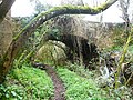
 Old Lock on the now Derelict Thames and Severn Canal - geograph.org.uk - 3921877.jpg 4,608 × 3,456; 6.11 MB
-
 On the Monarch's Way (1) - geograph.org.uk - 6002951.jpg 4,320 × 3,240; 3.85 MB
-
 On the Monarch's Way (10) - geograph.org.uk - 6003563.jpg 4,320 × 3,240; 5.62 MB
-
 On the Monarch's Way (11) - geograph.org.uk - 6003564.jpg 3,240 × 4,320; 5.48 MB
-
 On the Monarch's Way (12) - geograph.org.uk - 6003565.jpg 4,320 × 3,240; 4.42 MB
-
 On the Monarch's Way (13) - geograph.org.uk - 6003566.jpg 4,320 × 3,240; 4.5 MB
-
 On the Monarch's Way (14) - geograph.org.uk - 6003569.jpg 4,320 × 3,240; 4.64 MB
-
 On the Monarch's Way (15) - geograph.org.uk - 6003572.jpg 4,320 × 3,240; 4.93 MB
-
 On the Monarch's Way (16) - geograph.org.uk - 6003573.jpg 4,320 × 3,240; 4.66 MB
-
 On the Monarch's Way (17) - geograph.org.uk - 6003574.jpg 4,320 × 3,240; 4.07 MB
-
 On the Monarch's Way (18) - geograph.org.uk - 6004375.jpg 4,320 × 3,240; 3.91 MB
-
 On the Monarch's Way (2) - geograph.org.uk - 6002957.jpg 4,320 × 3,240; 3.8 MB
-
 On the Monarch's Way (3) - geograph.org.uk - 6002961.jpg 4,320 × 3,240; 3.23 MB
-
 On the Monarch's Way (4) - geograph.org.uk - 6003554.jpg 4,320 × 3,240; 5.18 MB
-
 On the Monarch's Way (5) - geograph.org.uk - 6003555.jpg 4,320 × 3,240; 4.62 MB
-
 On the Monarch's Way (6) - geograph.org.uk - 6003556.jpg 4,320 × 3,240; 5.01 MB
-
 On the Monarch's Way (7) - geograph.org.uk - 6003557.jpg 4,320 × 3,240; 3.88 MB
-
 On the Monarch's Way (8) - geograph.org.uk - 6003560.jpg 4,320 × 3,240; 3.92 MB
-
 On the Monarch's Way (9) - geograph.org.uk - 6003562.jpg 4,320 × 3,240; 4.7 MB
-
-
 Paddock, Coates - geograph.org.uk - 898493.jpg 640 × 371; 134 KB
-
 Parish church - geograph.org.uk - 6006348.jpg 4,194 × 3,145; 2.21 MB
-
 Path becomes a track - geograph.org.uk - 6006347.jpg 4,320 × 3,240; 4.17 MB
-
 Plaque, The Old School, Coates - geograph.org.uk - 1517808.jpg 640 × 479; 209 KB
-
 Please close the gate - geograph.org.uk - 6005026.jpg 3,600 × 2,700; 2.26 MB
-
 Ploughed field at Kemble - geograph.org.uk - 2379838.jpg 680 × 1,024; 267 KB
-
 Pump and hydrant, Quaker Row, Coates - geograph.org.uk - 1517887.jpg 507 × 640; 228 KB
-
 Pump House, Coatesfield Bridge - geograph.org.uk - 1234822.jpg 640 × 480; 102 KB
-
 Railway bridge - Bassett Dockem - geograph.org.uk - 1892739.jpg 1,500 × 1,000; 1.46 MB
-

-
 Rape Field from The Monarch's Way Path - geograph.org.uk - 3921892.jpg 4,429 × 3,254; 6.5 MB
-
 River source (1) - geograph.org.uk - 6002947.jpg 4,320 × 3,240; 6.03 MB
-
 River source (2) - geograph.org.uk - 6002949.jpg 4,320 × 3,240; 5.7 MB
-
 River Thames - Fosse Way Culvert - geograph.org.uk - 3338680.jpg 3,488 × 2,616; 2.17 MB
-
 River Thames - geograph.org.uk - 3338643.jpg 3,296 × 2,472; 1.69 MB
-
 River Thames - geograph.org.uk - 3338651.jpg 3,488 × 2,616; 2.23 MB
-
 River Thames - near Thames Head - geograph.org.uk - 3338584.jpg 2,616 × 3,488; 1.95 MB
-
 River Thames and Thames Path - geograph.org.uk - 3338660.jpg 3,488 × 2,616; 2.18 MB
-
 River Thames near Thames Head - geograph.org.uk - 3338598.jpg 3,156 × 2,367; 1.57 MB
-
 River Thames near Thames Head - geograph.org.uk - 3338620.jpg 3,377 × 2,533; 1.74 MB
-
 River Thames pool outlet upstream of Fosse Way - geograph.org.uk - 3338671.jpg 3,488 × 2,616; 2.15 MB
-
 River Thames upstream of the Fosse Way - geograph.org.uk - 3338665.jpg 3,488 × 2,616; 2.18 MB
-
 Road in Coates - geograph.org.uk - 1235093.jpg 640 × 480; 88 KB
-
 Road junction near Coates - geograph.org.uk - 3879870.jpg 1,024 × 680; 226 KB
-
 Road near Hailey Lodge - geograph.org.uk - 3881143.jpg 1,024 × 680; 310 KB
-
 Road north of Coates - geograph.org.uk - 1235151.jpg 640 × 480; 99 KB
-
 Rolling the field - geograph.org.uk - 6058169.jpg 4,320 × 3,240; 3 MB
-

-
 Round Tower, Thames and Severn Canal (geograph 4812126).jpg 531 × 800; 114 KB
-
 Route of the former Thames and Severn Canal - geograph.org.uk - 3921881.jpg 4,608 × 3,456; 6.55 MB
-
 Ruined Building near College Farm - geograph.org.uk - 3921897.jpg 3,134 × 2,454; 3.69 MB
-
 Sawmill road junction in Hailey Wood - geograph.org.uk - 465964.jpg 640 × 477; 145 KB
-

-

-
 Slurry spreading near Coates - geograph.org.uk - 3881097.jpg 1,024 × 680; 193 KB
-
 Small layby near Thames Head - geograph.org.uk - 5445862.jpg 800 × 600; 105 KB


_-_geograph.org.uk_-_6058173.jpg)
_-_geograph.org.uk_-_6058177.jpg)
_-_geograph.org.uk_-_6058178.jpg)


.jpg)


_-_geograph.org.uk_-_4085876.jpg)


_-_geograph.org.uk_-_6004374.jpg)
_-_geograph.org.uk_-_6004521.jpg)
_-_geograph.org.uk_-_6004524.jpg)
_-_geograph.org.uk_-_6004530.jpg)
_-_geograph.org.uk_-_6005018.jpg)
_-_geograph.org.uk_-_6005019.jpg)
_-_geograph.org.uk_-_6005020.jpg)
_-_geograph.org.uk_-_6004387.jpg)
_-_geograph.org.uk_-_6004389.jpg)
_-_geograph.org.uk_-_6004392.jpg)
_-_geograph.org.uk_-_6004393.jpg)
_-_geograph.org.uk_-_6004394.jpg)
_-_geograph.org.uk_-_6004398.jpg)
_-_geograph.org.uk_-_6004492.jpg)
_-_geograph.org.uk_-_6004502.jpg)


.jpg)


.jpg)
.jpg)
.jpg)
.jpg)
.jpg)
.jpg)
.jpg)


.jpg)
.jpg)
.jpg)


_-_geograph.org.uk_-_6004376.jpg)
_-_geograph.org.uk_-_6004377.jpg)
_-_geograph.org.uk_-_6004385.jpg)


.jpg)


_-_geograph.org.uk_-_6002951.jpg)
_-_geograph.org.uk_-_6003563.jpg)
_-_geograph.org.uk_-_6003564.jpg)
_-_geograph.org.uk_-_6003565.jpg)
_-_geograph.org.uk_-_6003566.jpg)
_-_geograph.org.uk_-_6003569.jpg)
_-_geograph.org.uk_-_6003572.jpg)
_-_geograph.org.uk_-_6003573.jpg)
_-_geograph.org.uk_-_6003574.jpg)
_-_geograph.org.uk_-_6004375.jpg)
_-_geograph.org.uk_-_6002957.jpg)
_-_geograph.org.uk_-_6002961.jpg)
_-_geograph.org.uk_-_6003554.jpg)
_-_geograph.org.uk_-_6003555.jpg)
_-_geograph.org.uk_-_6003556.jpg)
_-_geograph.org.uk_-_6003557.jpg)
_-_geograph.org.uk_-_6003560.jpg)
_-_geograph.org.uk_-_6003562.jpg)


_-_geograph.org.uk_-_6002947.jpg)
_-_geograph.org.uk_-_6002949.jpg)


.jpg)


