Category:Condercum (Benwell)
English: Condercum was a Roman fort at modern-day Benwell, a suburb of Newcastle upon Tyne, England. It was the third fort on Hadrian's Wall, after Segedunum (Wallsend) and Pons Aelius (Newcastle), and was situated 2 miles (3 km) to the west of the city. Today, nothing can be seen of the fort or its adjoining wall, as the site is covered by buildings and is crossed by the A186 Newcastle to Carlisle road. The remains of a small temple dedicated to Antenociticus, a local deity, can be seen nearby, and the original causeway over the vallum, or ditch, can also be seen.
human settlement in United Kingdom _Temple_of_Antenociticus_(2)_-_geograph.org.uk_-_837881.jpg) | |||||
| Upload media | |||||
| Instance of | |||||
|---|---|---|---|---|---|
| Part of | |||||
| Location |
| ||||
| Owned by | |||||
| Operator | |||||
 | |||||
Subcategories
This category has the following 2 subcategories, out of 2 total.
T
- Temple of Antenociticus (4 F)
V
Media in category "Condercum (Benwell)"
The following 10 files are in this category, out of 10 total.
-
 Condercum Befunde1926-1937.png 1,625 × 1,732; 617 KB
-

-

-

-
 Balineum Benwell.png 672 × 496; 41 KB
-
 Condercum1929.png 960 × 726; 1.06 MB
-
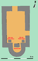 Grundriss Antenociticustempel Benwell.png 451 × 719; 21 KB
-
 Lageplan Condercum.png 968 × 716; 295 KB
-
 Vallum tor benwell.jpg 433 × 669; 83 KB
-
 Vicus Condercum.png 806 × 491; 1,011 KB

_Condercum_(Benwell)_Roman_Fort_(2)_-_geograph.org.uk_-_837865.jpg)
_Condercum_(Benwell)_Roman_Fort_(3)_-_geograph.org.uk_-_837869.jpg)
_Condercum_(Benwell)_Roman_Fort_-_geograph.org.uk_-_837861.jpg)


