Category:Creu de Castell d'Aro
| Object location | | View all coordinates using: OpenStreetMap |
|---|
 | |||||
| Upload media | |||||
| Instance of | |||||
|---|---|---|---|---|---|
| Location | Castell d'Aro, Platja d'Aro i s'Agaró, Baix Empordà, Province of Girona, Catalonia | ||||
| Heritage designation |
| ||||
 | |||||
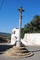
Català: Creu de Castell d'Aro, creu de terme. Plaça de la Creu, Platja d'Aro. A ponent del poble, direcció Mas Sicars, al mig de dues vies urbanes (Castell-Platja d'Aro)
This is a category about a building listed in the Catalan heritage register as Bé Cultural d'Interès Local (BCIL) under the reference IPA-30787. |
Media in category "Creu de Castell d'Aro"
The following 2 files are in this category, out of 2 total.
-
 Castell d'Aro. Creu de terme.JPG 1,944 × 2,896; 1.69 MB
-
 Creu de terme de Castell d'Aro.JPG 1,944 × 2,896; 2.52 MB
