Category:Crypt of St. Liudger (Leer)
| Object location | | View all coordinates using: OpenStreetMap |
|---|
| Upload media | |||||
| Instance of | |||||
|---|---|---|---|---|---|
| Location | Leer, Lower Saxony, Germany | ||||
 | |||||
Subcategories
This category has only the following subcategory.
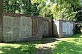
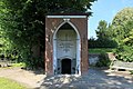
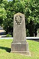
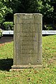
Media in category "Crypt of St. Liudger (Leer)"
The following 15 files are in this category, out of 15 total.
-
 Kryptaleer.JPG 3,456 × 2,304; 1.55 MB
-
 Leer - Plytenbergstraße - Alter reformierter Friedhof - Krypta 01 ies.jpg 5,616 × 3,745; 22.44 MB
-
 Leer - Plytenbergstraße - Alter reformierter Friedhof - Krypta 02 ies.jpg 3,745 × 5,616; 21.55 MB
-
 Leer - Plytenbergstraße - Alter reformierter Friedhof - Krypta 03 ies.jpg 3,744 × 5,616; 20.06 MB
-
 Leer - Plytenbergstraße - Alter reformierter Friedhof - Krypta 04 ies.jpg 5,616 × 3,744; 24.58 MB
-
 Leer - Plytenbergstraße - Alter reformierter Friedhof - Krypta 05 ies.jpg 5,616 × 3,744; 27.05 MB
-
 Leer - Plytenbergstraße - Alter reformierter Friedhof - Krypta 06 ies.jpg 5,616 × 3,744; 15.74 MB
-
 Leer - Plytenbergstraße - Alter reformierter Friedhof - Krypta 07 ies.jpg 5,616 × 3,744; 21.61 MB
-
 Leer - Plytenbergstraße - Alter reformierter Friedhof - Krypta 08 ies.jpg 3,744 × 5,616; 18.6 MB
-
 Leer - Plytenbergstraße - Alter reformierter Friedhof - Krypta 09 ies.jpg 3,745 × 5,616; 16.47 MB
-
 Leer - Plytenbergstraße - Alter reformierter Friedhof - Krypta 10 ies.jpg 3,744 × 5,616; 24.38 MB
-
 Leer - Plytenbergstraße - Alter reformierter Friedhof - Krypta 11 ies.jpg 3,744 × 5,616; 23.94 MB
-
 Leer - Plytenbergstraße - Alter reformierter Friedhof - Krypta 12 ies.jpg 3,744 × 5,616; 24.07 MB
-
 Leer - Plytenbergstraße - Alter reformierter Friedhof - Krypta 13 ies.jpg 5,616 × 3,743; 24.32 MB
-
 Leer - Plytenbergstraße - Alter reformierter Friedhof - Krypta 14 ies.jpg 5,616 × 3,746; 24.8 MB


