Category:Cushman Dam No. 2
dam on the North Fork Skokomish River in Washington state listed on National Register of Historic Places  | |||||
| Upload media | |||||
| Instance of | |||||
|---|---|---|---|---|---|
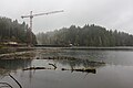
| Location | Mason County, Washington, Pacific Northwest, Washington, Pacific States Region | ||||
| Located in or next to body of water |
| ||||
| Owned by |
| ||||
| Heritage designation | |||||
| Inception |
| ||||
| Nominal power capacity |
| ||||
| Length |
| ||||
| Height |
| ||||
| Elevation above sea level |
| ||||
| Drainage basin |
| ||||
| Reservoir created |
| ||||
 | |||||
|
This is a category about a place or building that is listed on the National Register of Historic Places in the United States of America. Its reference number is 88002757. |
Media in category "Cushman Dam No. 2"
The following 6 files are in this category, out of 6 total.
-
 Cushman dam 2.jpg 4,844 × 3,229; 3 MB
-
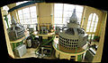 Cushman Dam No 2 turbines panoramic.jpg 6,619 × 3,931; 9.38 MB
-
 Cushman No. 2 Hydroelectric Power Plant 1.JPG 3,008 × 2,000; 3.01 MB
-
 Cushman No. 2 Hydroelectric Power Plant 2.jpg 3,008 × 2,000; 3.55 MB
-
 Cushman No. 2 Hydroelectric Power Plant sign.jpg 1,488 × 1,074; 1.17 MB
-
 Cushman Powerhouse No. 2 in Mason County, WA.jpg 4,912 × 3,264; 5.12 MB


