Category:Cwmfelinfach
village in United Kingdom  | |||||
| Upload media | |||||
| Instance of | |||||
|---|---|---|---|---|---|
| Location | Caerphilly County Borough, Wales | ||||
 | |||||
English: Cwmfelinfach is a small village located in the Sirhowy valley of south-east Wales. It is part of the district of Caerphilly within the historic boundaries of Monmouthshire. Located north of Wattsville and about 5 miles north of the nearest town Risca and south of Blackwood.
Media in category "Cwmfelinfach"
The following 14 files are in this category, out of 14 total.
-

-
 Celtic Trail.jpg 3,264 × 2,448; 2.8 MB
-
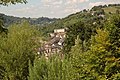 Cwmfelinfach seen from Ynyshowell - geograph.org.uk - 341770.jpg 640 × 425; 114 KB
-
 Dewpond near Pen-heol-machen - geograph.org.uk - 736461.jpg 639 × 479; 160 KB
-
 Islwyn Road, Cwmfelinfach - geograph.org.uk - 429378.jpg 640 × 474; 71 KB
-
 Memorial Gardens, Cwmfelinfach - geograph.org.uk - 1575089.jpg 640 × 480; 166 KB
-
 New Road Cwmfelinfach - geograph.org.uk - 713817.jpg 640 × 428; 82 KB
-
 On Twyn yr Oerfel - geograph.org.uk - 736449.jpg 639 × 479; 219 KB
-
 Sirhowy - panoramio (1).jpg 3,648 × 2,056; 3.45 MB
-
 Sirhowy - panoramio (8).jpg 3,648 × 2,056; 3.55 MB
-
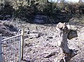
 Tempting gate - geograph.org.uk - 736467.jpg 639 × 479; 201 KB
-
 Very old quarry - geograph.org.uk - 736881.jpg 638 × 475; 59 KB
-
 View of Cwmfelinfach - geograph.org.uk - 1418263.jpg 640 × 640; 328 KB
-
 War Memorial, Cwmfelinfach - geograph.org.uk - 1575082.jpg 482 × 640; 110 KB


.jpg)
.jpg)


