Category:De Eshof
| Object location | | View all coordinates using: OpenStreetMap |
|---|
| Object location | | View all coordinates using: OpenStreetMap |
|---|
 | |||||
| Upload media | |||||
| Instance of | |||||
|---|---|---|---|---|---|
| Part of | |||||
| Location | Haren, Groningen, Netherlands | ||||
| Street address |
| ||||
| Heritage designation |
| ||||
| Inception |
| ||||
 | |||||
Nederlands: Begraafplaats De Eshof, Rijksstraatweg 290, Haren, Groningen (rmc 513800). Aangelegd in 1895, uitgebreid in 1918, later nogmaals uitgebreid. Bestaat uit de volgende onderdelen:
- Begraafplaats (rm 513801)
- Baarhuisje (1885, rm 513802)
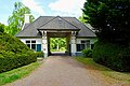
- Poortgebouw met aula en dienstwoning (1918, Kuiler & Drewes, rm 513803)
- Begraafplaatshek (ca. 1885, rm 513804)
- Begraafplaatshek (ca. 1885, rm 513805)
- Schuurtje (1918, rm 513806)
- Zonnewijzer (1919, rm 513807)
|
This is a category about rijksmonumentcomplex number 513800
|
|
This is a category about rijksmonument number 513801
|
|
This is a category about rijksmonument number 513802
|
|
This is a category about rijksmonument number 513803
|
|
This is a category about rijksmonument number 513804
|
|
This is a category about rijksmonument number 513805
|
|
This is a category about rijksmonument number 513806
|
|
This is a category about rijksmonument number 513807
|
| Address |
|
Subcategories
This category has only the following subcategory.
Media in category "De Eshof"
The following 11 files are in this category, out of 11 total.
-
 20100922 Rijksstraatweg 290 (noordelijk hek De Eshof) Haren Gn NL.jpg 2,500 × 2,000; 4.37 MB
-
 20100922 Rijksstraatweg 290 (zonnewijzer De Eshof) Haren Gn NL.jpg 2,400 × 3,000; 4.91 MB
-
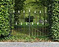 20100922 Rijksstraatweg 290 (zuidelijk hek De Eshof) Haren Gn NL.jpg 2,500 × 2,000; 4.1 MB
-
 20220517 de Eshof1 Haren.jpg 5,184 × 3,456; 3.78 MB
-
 20220517 de Eshof2 Haren.jpg 5,184 × 3,456; 6.31 MB
-
 20220517 zonnewijzer de Eshof Haren.jpg 3,456 × 5,184; 5.29 MB
-
 Haren Eshof schuurtje.JPG 3,648 × 2,736; 6 MB
-
 Haren Eshof.JPG 3,648 × 2,736; 6.47 MB
-
 Haren Poortgebouw Eshof.JPG 4,000 × 3,000; 6.53 MB
-
 Sevensma graf moeder en zoon Eshof 20220802 152647 (2).jpg 3,096 × 4,128; 5.7 MB
-
 Sevensma graf vader Eshof 20220802 143651.jpg 3,096 × 4,128; 5.5 MB
_Haren_Gn_NL.jpg)
_Haren_Gn_NL.jpg)
_Haren_Gn_NL.jpg)


.jpg)
