Category:De Gecroonde Raep
| Object location | | View all coordinates using: OpenStreetMap |
|---|
 | |||||
| Upload media | |||||
| Instance of | |||||
|---|---|---|---|---|---|
| Location | Amsterdam, North Holland, Netherlands | ||||
| Street address |
| ||||
| Located on street | |||||
| Architect | |||||
| Owned by |
| ||||
| Heritage designation |
| ||||
| Inception |
| ||||
 | |||||
|
This is a category about rijksmonument number 6042
|
| Address |
|
Media in category "De Gecroonde Raep"
The following 19 files are in this category, out of 19 total.
-
 De Schoonheid Van Amsterdam (60327540).jpeg 2,048 × 1,152; 1.08 MB
-
 Exterieur VOORGEVEL, DETAIL - Amsterdam - 20298757 - RCE.jpg 1,188 × 1,200; 395 KB
-
 Exterieur VOORGEVEL, DETAIL - Amsterdam - 20298758 - RCE.jpg 1,192 × 1,200; 289 KB
-
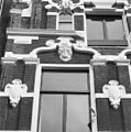 Exterieur VOORGEVEL, DETAIL - Amsterdam - 20298759 - RCE.jpg 1,190 × 1,200; 313 KB
-
 Exterieur VOORGEVEL, TOP - Amsterdam - 20298756 - RCE.jpg 1,197 × 1,200; 400 KB
-
 Exterieur VOORGEVELS, OVERZICHT - Amsterdam - 20298755 - RCE.jpg 960 × 1,200; 323 KB
-
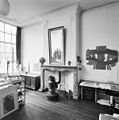 INTERIEUR, ACHTERKAMER, SCHOUW - Amsterdam - 20298761 - RCE.jpg 1,193 × 1,200; 260 KB
-
 INTERIEUR, ACHTERKAMER, SCHUIFDEUREN - Amsterdam - 20298762 - RCE.jpg 1,192 × 1,200; 254 KB
-
 INTERIEUR, GANG, OVERZICHT - Amsterdam - 20298760 - RCE.jpg 1,200 × 1,197; 219 KB
-
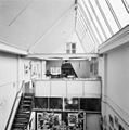 INTERIEUR, KAP, OVERZICHT - Amsterdam - 20298763 - RCE.jpg 1,193 × 1,200; 220 KB
-
 Oudezijds Voorburgwal 45-57 Amsterdam.jpg 2,592 × 1,936; 2.19 MB
-
 Oudezijds Voorburgwal 49-59 Amsterdam.jpg 2,592 × 1,936; 2.1 MB
-
 Oudezijds Voorburgwal 55 Amsterdam.jpg 1,936 × 2,592; 2.15 MB
-
 Oudezijds Voorburgwal 57 Amsterdam.jpg 2,592 × 1,936; 2.39 MB
-
 Oudezijds Voorburgwal 59 Amsterdam.jpg 2,592 × 1,936; 2.39 MB
-
 Overzicht voorgevels - Amsterdam - 20021527 - RCE.jpg 894 × 1,200; 195 KB
-

-
 Stadsarchief Amsterdam, Afb 012000005839.jpg 2,746 × 2,036; 960 KB
-
 Steenbergh, C.J. (1859-1939), Afb 012000009346.jpg 2,092 × 2,819; 857 KB
.jpeg)


,_Afb_012000009346.jpg)