Category:De Hoop, Maassluis
| Object location | | View all coordinates using: OpenStreetMap |
|---|
windmill in Maassluis, Netherlands  | |||||
| Upload media | |||||
| Instance of | |||||
|---|---|---|---|---|---|
| Location | Maassluis, South Holland, Netherlands | ||||
| Street address |
| ||||
| Located on street |
| ||||
| Has use | |||||
| Heritage designation |
| ||||
| Inception |
| ||||
| Source of energy | |||||
 | |||||
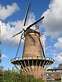
Nederlands: Korenmolen De Hoop in Maassluis is een stellingmolen die in 1792 werd gebouwd. Een houten voorganger werd in 1620 op deze plaats opgericht.
|
This is a category about rijksmonument number 26629
|
| Address |
|
Media in category "De Hoop, Maassluis"
The following 47 files are in this category, out of 47 total.
-

-
 Gevelsteen en ANWB-bord bij korenmolen - AMR Molenfoto - 20538644 - RCE.jpg 900 × 1,200; 257 KB
-

-
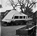
 Kap van stellingmolen op werkplaats te Kethel - Maassluis - 20145196 - RCE.jpg 1,200 × 1,175; 322 KB
-
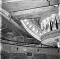 Korenmolen De Hoop, bovenschijf met kruiwerk - Maassluis - 20145208 - RCE.jpg 1,200 × 1,183; 218 KB
-
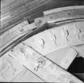
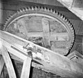
 Korenmolen De Hoop, bovenwiel - Maassluis - 20145207 - RCE.jpg 1,200 × 1,170; 255 KB
-

-

-
 Maalstenen aan de west-zijde in de molen - Maassluis - 20145203 - RCE.jpg 1,200 × 1,170; 219 KB
-
 Maassluis (160) (8216617612).jpg 1,532 × 2,018; 652 KB
-
 Maassluis 046.JPG 2,448 × 3,264; 2 MB
-
 Maassluis molen De Hoop bij avond gezien vanaf de Zuiddijk.jpg 1,296 × 2,001; 1.19 MB
-
 Maassluis molen De Hoop nat molendag 2008.jpg 1,400 × 1,867; 1.38 MB
-
 Maassluis molen.jpg 1,200 × 1,600; 590 KB
-
 Maassluis, de molen 2009-08-23 14.48.JPG 1,944 × 2,592; 840 KB
-
 Maassluis-molen-januari-2005.jpg 320 × 240; 12 KB
-

-

-

-

-
 Molen De Hoop, Maassluis(2) (44210958584).jpg 5,299 × 6,152; 7.46 MB
-
 Nieuwe kap van stellingmolen - Maassluis - 20145197 - RCE.jpg 1,200 × 1,184; 300 KB
-
 Nieuwe kap van stellingmolen - Maassluis - 20145198 - RCE.jpg 1,200 × 1,177; 290 KB
-

-
 Schade aan stellingmolen na ongeluk 2 september 1963 - Maassluis - 20145188 - RCE.jpg 1,200 × 1,189; 346 KB
-
 Schade aan stellingmolen na ongeluk 2 september 1963 - Maassluis - 20145189 - RCE.jpg 1,200 × 1,190; 243 KB
-
 Schade aan stellingmolen na ongeluk 2 september 1963 - Maassluis - 20145190 - RCE.jpg 1,200 × 1,194; 275 KB
-
 Schade aan stellingmolen na ongeluk 2 september 1963 - Maassluis - 20145191 - RCE.jpg 1,200 × 1,193; 214 KB
-
 Schade aan stellingmolen na ongeluk 2 september 1963 - Maassluis - 20145193 - RCE.jpg 1,200 × 1,200; 181 KB
-
 Schade aan stellingmolen na ongeluk 2 september 1963 - Maassluis - 20145194 - RCE.jpg 1,200 × 1,191; 252 KB
-
 Schade aan stellingmolen na ongeluk 2 september 1963 - Maassluis - 20145195 - RCE.jpg 1,200 × 1,192; 269 KB
-

-
 Spoorwiel gezien vanaf de steenzolder - Maassluis - 20145204 - RCE.jpg 1,200 × 1,140; 204 KB
-

-

-
 Stellingmolen in vervallen staat - AMR Molenfoto - 20541963 - RCE.jpg 846 × 1,200; 141 KB
-
 Stellingmolen in vervallen toestand - Maassluis - 20145200 - RCE.jpg 802 × 1,200; 181 KB
-

-

-
 Stellingmolen van achteren gefotografeerd - AMR Molenfoto - 20538645 - RCE.jpg 900 × 1,200; 140 KB
-
 Stellingmolen van opzij gefotografeerd - AMR Molenfoto - 20538643 - RCE.jpg 900 × 1,200; 147 KB
-
 Stellingmolen van opzij gefotografeerd - Maassluis - 20145185 - RCE.jpg 817 × 1,200; 144 KB
-
 Stellingmolen van voren gefotografeerd - AMR Molenfoto - 20538642 - RCE.jpg 900 × 1,200; 125 KB
-

-

-
 Straat met ronde stenen stellingmolen - AMR Molenfoto - 20538641 - RCE.jpg 1,200 × 900; 165 KB
-
 Vergezicht met ronde stenen stellingmolen - AMR Molenfoto - 20538640 - RCE.jpg 1,200 × 900; 131 KB


_(8216617612).jpg)


_(44210958584).jpg)


