Category:De Steenen Camer
| Object location | | View all coordinates using: OpenStreetMap |
|---|
 | |||||
| Upload media | |||||
| Instance of | |||||
|---|---|---|---|---|---|
| Location | Arnhem, Gelderland, Netherlands | ||||
| Street address |
| ||||
| Heritage designation |
| ||||
 | |||||
|
This is a category about rijksmonument number 8384
|
| Address |
|
Media in category "De Steenen Camer"
The following 54 files are in this category, out of 54 total.
-
 Achter- en zijgevel - Elden - 20457368 - RCE.jpg 1,200 × 900; 158 KB
-
 Achtergevel - Elden - 20457371 - RCE.jpg 1,200 × 900; 172 KB
-
 Achtergevel boerderij - Elden - 20069352 - RCE.jpg 1,193 × 1,200; 303 KB
-
 Achtergevels - Elden - 20457370 - RCE.jpg 649 × 890; 100 KB
-
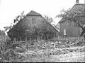
 Boerderij "De Steenen Camer", overzicht - Elden - 20069348 - RCE.jpg 1,192 × 1,200; 364 KB
-
 Boerderij en schuren nr. F 208-29 - Elden - 20457337 - RCE.jpg 1,200 × 900; 112 KB
-
 De Steenen Camer te Elden - WLM 2011 - wardvanwanrooij.jpg 1,024 × 768; 389 KB
-
 Detail gevel, inkassing kleur - Elden - 20457340 - RCE.jpg 1,200 × 900; 147 KB
-
 Detail kadastrale minuutplan 1832 - Elden - 20457373 - RCE.jpg 1,200 × 900; 205 KB
-
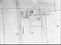 Detail kadastrale minuutplan 1832 - Elden - 20457383 - RCE.jpg 1,200 × 900; 167 KB
-
 Detail kadastrale verzamelkaart 1819 - Elden - 20457380 - RCE.jpg 1,200 × 900; 132 KB
-
 Detail kadastrale verzamelkaart 1819 - Elden - 20457382 - RCE.jpg 1,200 × 900; 153 KB
-
 Detail topokaart miltiaire kaart 1850 - Elden - 20457350 - RCE.jpg 1,200 × 900; 209 KB
-
 Detail topokaart nr. 490 1910 - Elden - 20457355 - RCE.jpg 1,200 × 900; 198 KB
-
 Detail voorgevel, kelderraam kelderraam kleur - Elden - 20457391 - RCE.jpg 1,200 × 900; 144 KB
-
 Detail waterstaatskaart 1916 blad 4 - Elden - 20457348 - RCE.jpg 1,200 × 900; 141 KB
-
 Doorloop tussen de bedrijfsgedeelten - Elden - 20457375 - RCE.jpg 1,200 × 900; 172 KB
-
 Huidige kadastrale situatie 1972 - Elden - 20457377 - RCE.jpg 1,200 × 900; 142 KB
-
 Huis en schuur zie dia nr. 4881 - Elden - 20457388 - RCE.jpg 1,200 × 900; 145 KB
-
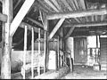
 Interier deel, detail ankerbalkgebint kleur - Elden - 20457374 - RCE.jpg 1,200 × 900; 136 KB
-
 Kadastrale hermeting 1962 - Elden - 20457378 - RCE.jpg 1,200 × 900; 160 KB
-
 Kadastrale hermeting 1962 - Elden - 20457379 - RCE.jpg 1,200 × 900; 189 KB
-
 Kadastrale hermeting 1962 - Elden - 20457390 - RCE.jpg 1,200 × 900; 169 KB
-
 Kadastrale veldwerk 6-4-1864 - Elden - 20457381 - RCE.jpg 1,200 × 900; 161 KB
-
 Kop- en zijgevel - Elden - 20457365 - RCE.jpg 1,200 × 900; 189 KB
-
 Luchtfoto 1950 - Elden - 20457336 - RCE.jpg 1,200 × 900; 212 KB
-
 Militaire kaart 1850 - Elden - 20457352 - RCE.jpg 1,200 × 900; 253 KB
-
 Oelebord schuur - Elden - 20457345 - RCE.jpg 637 × 888; 52 KB
-
 Open loods - Elden - 20457362 - RCE.jpg 1,200 × 900; 173 KB
-
 Open loods anno 1946 - Elden - 20457363 - RCE.jpg 1,200 × 900; 173 KB
-
 Overzicht achtergevel - Elden - 20069353 - RCE.jpg 1,195 × 1,200; 419 KB
-
 Rechterzij- en achtergevel - Elden - 20457372 - RCE.jpg 1,200 × 900; 178 KB
-
 Schuur, boerderij en hooiberg - Elden - 20457364 - RCE.jpg 1,200 × 900; 175 KB
-
 Scouting Arnhem building and pancake restaurant "de stenen kamer" - panoramio.jpg 4,928 × 3,264; 6.16 MB
-
 Stal - Elden - 20457358 - RCE.jpg 1,200 × 900; 126 KB
-
 Stal - Elden - 20457359 - RCE.jpg 1,200 × 900; 206 KB
-
 Stal - Elden - 20457361 - RCE.jpg 1,200 × 900; 202 KB
-
 Stal zie dia nr. 4883 - Elden - 20457360 - RCE.jpg 1,200 × 900; 174 KB
-
 Topokaart nr. 490 1910 - Elden - 20457339 - RCE.jpg 1,200 × 900; 237 KB
-
 Voor- en zijgevel - Elden - 20457357 - RCE.jpg 1,200 × 900; 141 KB
-
 Voor- en zijgevel - Elden - 20457386 - RCE.jpg 1,200 × 900; 239 KB
-
 Voorgevel - Elden - 20069349 - RCE.jpg 1,195 × 1,200; 396 KB
-
 Voorgevel - Elden - 20069350 - RCE.jpg 1,188 × 1,200; 397 KB
-
 Voorgevel - Elden - 20457385 - RCE.jpg 1,200 × 900; 196 KB
-
 Voorgevel schuur - Elden - 20069351 - RCE.jpg 1,181 × 1,200; 332 KB
-
 Waterstaatskaart 1916 - Elden - 20457353 - RCE.jpg 1,200 × 900; 184 KB
-
 Zij- en achtergevel - Elden - 20457369 - RCE.jpg 1,200 × 900; 214 KB
-
 Zij- en achtergevel zie dia nr. 4882 - Elden - 20457367 - RCE.jpg 1,200 × 900; 160 KB
-
 Zij- en voorgevel - Elden - 20457387 - RCE.jpg 1,200 × 900; 213 KB
-
 Zij- en voorgevel zie dia nr. 4880 - Elden - 20457384 - RCE.jpg 1,200 × 900; 241 KB
-
 Zijgevel - Elden - 20457366 - RCE.jpg 1,200 × 900; 137 KB
-
 Zijgevel woongedeelte kleur - Elden - 20457376 - RCE.jpg 1,200 × 900; 217 KB
-
 Zolder - Elden - 20457343 - RCE.jpg 1,200 × 900; 111 KB
-
 Zolder - Elden - 20457344 - RCE.jpg 1,200 × 900; 118 KB


