Category:De Volharding, Jislum
| Object location | | View all coordinates using: OpenStreetMap |
|---|
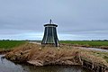
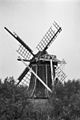
windmill in Jislum, Netherlands  | |||||
| Upload media | |||||
| Instance of |
| ||||
|---|---|---|---|---|---|
| Location | Jislum, Noardeast-Fryslân, Friesland, Netherlands | ||||
| Has use |
| ||||
| Heritage designation |
| ||||
| Source of energy | |||||
 | |||||
|
This is a category about rijksmonument number 15632
|
| Address |
|
Media in category "De Volharding, Jislum"
The following 16 files are in this category, out of 16 total.
-
 2022 Jislum, muonts 'De Volharding' nei de restauraasje fan oktober 2022 A.jpg 3,493 × 2,325; 2.21 MB
-
 2022 Jislum, muonts 'De Volharding' nei de restauraasje fan oktober 2022 B.jpg 2,900 × 1,933; 1.57 MB
-
 2022 Jislum, muonts 'De Volharding' nei de restauraasje fan oktober 2022 C.jpg 2,836 × 1,889; 1.54 MB
-

-

-
 De Volharding, Jislum.jpg 2,842 × 1,895; 1.57 MB
-
 Inkijk in achtkante grondzeiler - AMR Molenfoto - 20538307 - RCE.jpg 1,200 × 900; 135 KB
-
 Poldermolen "De Volharding", overzicht - Jislum - 20120881 - RCE.jpg 1,199 × 1,200; 297 KB
-
 Poldermolen "De Volharding", overzicht - Jislum - 20120882 - RCE.jpg 1,197 × 1,200; 270 KB
-
 Poldermolen "De Volharding", overzicht - Jislum - 20120883 - RCE.jpg 1,190 × 1,200; 277 KB
-
 Poldermolen "De Volharding", overzicht - Jislum - 20120884 - RCE.jpg 1,200 × 1,198; 286 KB
-
 Poldermolen "De Volharding", overzicht - Jislum - 20120885 - RCE.jpg 1,197 × 1,200; 271 KB
-
 Volhardingjislum.jpg 1,944 × 2,592; 2.2 MB
-
 Watermolen van Groot Hickaert, aanzicht - Jislum - 20120872 - RCE.jpg 803 × 1,200; 168 KB
-
 Watermolen van Groot Hickaert, aanzicht - Jislum - 20120873 - RCE.jpg 1,200 × 787; 175 KB
-
 Watermolen van Groot Hickaert, aanzicht - Jislum - 20120874 - RCE.jpg 798 × 1,200; 167 KB


