Category:Deighton, Hambleton
village and civil parish in Hambleton, North Yorkshire, UK  | |||||
| Upload media | |||||
| Instance of | |||||
|---|---|---|---|---|---|
| Location | Hambleton, North Yorkshire, Yorkshire and the Humber, England | ||||
| Population |
| ||||
| Area |
| ||||
 | |||||
English: Deighton is a village and civil parish in the Hambleton district of North Yorkshire, England. It is about 6 miles north of Northallerton and near the A167 road.
Subcategories
This category has only the following subcategory.
A
- All Saints Church, Deighton (2 F)
Media in category "Deighton, Hambleton"
The following 90 files are in this category, out of 90 total.
-
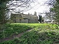 All Saints Church, from the north-east - geograph.org.uk - 4413544.jpg 1,024 × 768; 234 KB
-
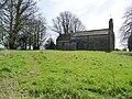 All Saints Church, from the north-west - geograph.org.uk - 4413538.jpg 1,024 × 768; 208 KB
-
 Anonymous lane at a 73 metre spot height - geograph.org.uk - 4414550.jpg 1,024 × 768; 128 KB
-
 Anonymous lane at a 79 metre spot height - geograph.org.uk - 4414531.jpg 1,024 × 768; 128 KB
-

-
-
 Blackberry Grange. - geograph.org.uk - 531679.jpg 640 × 480; 137 KB
-
 Blind Lane (track and public bridleway) - geograph.org.uk - 4414562.jpg 1,024 × 768; 209 KB
-

-
 Brompton Farm - geograph.org.uk - 3237626.jpg 640 × 480; 30 KB
-
 Concrete track heading west to Blackberry Grange - geograph.org.uk - 4414602.jpg 1,024 × 768; 139 KB
-
 Cottages, Deighton - geograph.org.uk - 3237649.jpg 640 × 480; 55 KB
-
 Course of Roman Road - geograph.org.uk - 1104873.jpg 640 × 480; 91 KB
-
 Crop field off Deighton Lane - geograph.org.uk - 3237642.jpg 640 × 469; 54 KB
-
 Deighton From Town End Farm - geograph.org.uk - 323459.jpg 640 × 426; 58 KB
-
 Deighton Lane - geograph.org.uk - 3237655.jpg 640 × 480; 66 KB
-
 Deighton Lane - geograph.org.uk - 4737976.jpg 640 × 480; 85 KB
-
 Deighton Lane - geograph.org.uk - 4737979.jpg 640 × 480; 70 KB
-
 Deighton Lane heading north - geograph.org.uk - 3237637.jpg 640 × 480; 33 KB
-
 Deighton Lane heading north - geograph.org.uk - 3237647.jpg 640 × 480; 62 KB
-
 Deighton Lane heading west - geograph.org.uk - 3237663.jpg 640 × 480; 61 KB
-
 Deighton Lane heading west - geograph.org.uk - 3237674.jpg 640 × 480; 39 KB
-
 Deighton Lane view - geograph.org.uk - 5771891.jpg 2,048 × 1,536; 792 KB
-
 Deighton village - geograph.org.uk - 3620664.jpg 640 × 480; 94 KB
-
 Deighton Village Hall - geograph.org.uk - 4737974.jpg 640 × 480; 59 KB
-
 Entrance to Northfield Farm - geograph.org.uk - 276799.jpg 640 × 480; 109 KB
-
 Farm building, Brompton Farm - geograph.org.uk - 3237632.jpg 640 × 480; 49 KB
-
 Farm Track - geograph.org.uk - 347028.jpg 640 × 480; 85 KB
-
 Farmland east of Blackberry Farm - geograph.org.uk - 4414588.jpg 1,024 × 768; 173 KB
-
 Farmland near Deighton - geograph.org.uk - 3237662.jpg 640 × 480; 46 KB
-
 Farmland south of Long Lane - geograph.org.uk - 4413506.jpg 1,024 × 768; 153 KB
-
 Farmland south of Stripe Plantation - geograph.org.uk - 4414542.jpg 1,024 × 768; 172 KB
-
 Farmland south-east of Stripe Plantation - geograph.org.uk - 4414537.jpg 1,024 × 768; 173 KB
-
 Farmland west of Bratchet Hill - geograph.org.uk - 4414534.jpg 1,024 × 768; 176 KB
-
 Farmland west of Long Lane - geograph.org.uk - 4413509.jpg 1,024 × 768; 166 KB
-
 Farmland, Blackberry Farm - geograph.org.uk - 3237843.jpg 640 × 480; 58 KB
-
 Field and hedgerow, Deighton. - geograph.org.uk - 3620463.jpg 640 × 480; 77 KB
-
 Field entrance off Deighton Lane - geograph.org.uk - 3237659.jpg 640 × 480; 81 KB
-
 Field entrance, Sunnyside Farm - geograph.org.uk - 3237672.jpg 640 × 480; 68 KB
-
 Field Off Long Lane - geograph.org.uk - 289048.jpg 640 × 384; 64 KB
-
 Field or lake^ - geograph.org.uk - 3237644.jpg 640 × 463; 20 KB
-
 Fields East of Long Lane - geograph.org.uk - 322419.jpg 640 × 426; 85 KB
-
 Footpath heading south near Deighton - geograph.org.uk - 3237683.jpg 640 × 480; 64 KB
-
 Hedgerow in arable land - geograph.org.uk - 4357214.jpg 1,723 × 2,398; 766 KB
-
 Hedgerow Standard - geograph.org.uk - 4357207.jpg 2,169 × 2,320; 868 KB
-
 House in Deighton - geograph.org.uk - 3237650.jpg 640 × 480; 55 KB
-
 House near Summerfield House Farm - geograph.org.uk - 4414612.jpg 1,024 × 768; 193 KB
-
 Long Lane - geograph.org.uk - 289017.jpg 640 × 480; 126 KB
-
 Long Lane at a 58 metre spot height - geograph.org.uk - 4413304.jpg 1,024 × 768; 130 KB
-
 Long Lane view - geograph.org.uk - 5771876.jpg 2,048 × 1,536; 906 KB
-
 Long Lane, heading south towards Whorlton Nook - geograph.org.uk - 4413515.jpg 1,024 × 768; 147 KB
-
 Manor House, Deighton - geograph.org.uk - 290973.jpg 640 × 480; 71 KB
-
 Mill Hill Farm, Deighton - geograph.org.uk - 290242.jpg 640 × 480; 78 KB
-
 Near Deighton - geograph.org.uk - 5771885.jpg 2,048 × 1,536; 981 KB
-
 Public footpath entering Deighton from the east - geograph.org.uk - 4413555.jpg 1,024 × 768; 212 KB
-

-
 Road junction - geograph.org.uk - 4737967.jpg 640 × 480; 76 KB
-
 Roman Road heading north - geograph.org.uk - 3237688.jpg 640 × 480; 43 KB
-
 Roman Road heading north - geograph.org.uk - 3237852.jpg 640 × 480; 53 KB
-
 Sunnyside Farm - geograph.org.uk - 290245.jpg 640 × 480; 72 KB
-
 Sunnyside Farm - geograph.org.uk - 3237677.jpg 640 × 480; 68 KB
-
 The A19 road north of Deighton - geograph.org.uk - 295057.jpg 640 × 480; 113 KB
-
 The former Roman road, heading south - geograph.org.uk - 4414607.jpg 1,024 × 768; 141 KB
-
 Towards North House Farm - geograph.org.uk - 347032.jpg 480 × 640; 85 KB
-
 Town Farm, Deighton - geograph.org.uk - 290247.jpg 640 × 480; 85 KB
-
 Track to Blackberry Farm - geograph.org.uk - 3237848.jpg 640 × 480; 52 KB
-
 Track to Sunnyside Farm - geograph.org.uk - 3237669.jpg 640 × 480; 75 KB
-
 Tree shadow, off Long Lane - geograph.org.uk - 4413525.jpg 1,024 × 768; 171 KB
-
 Trees along the route of a Roman road - geograph.org.uk - 4413531.jpg 1,024 × 768; 225 KB
-
 Trees and small pools, Deighton - geograph.org.uk - 4413548.jpg 1,024 × 768; 164 KB
-
 Valley Farm - geograph.org.uk - 290970.jpg 640 × 480; 46 KB
-
 Valley Farm - geograph.org.uk - 3620642.jpg 640 × 480; 80 KB
-
 View North West from Ashfield - geograph.org.uk - 91319.jpg 640 × 480; 61 KB
-

-
 Will someone put it back please^ - geograph.org.uk - 4414572.jpg 1,024 × 768; 190 KB
-
 Winter sunshine on the river - geograph.org.uk - 4357224.jpg 2,472 × 3,296; 1.88 MB
-
 Wiske Bridge - geograph.org.uk - 4323689.jpg 3,296 × 2,472; 1.82 MB
-
 Wiske Farm - geograph.org.uk - 4324574.jpg 3,296 × 2,472; 1.95 MB
-
 Wiske Farm, Little Smeaton - geograph.org.uk - 291053.jpg 640 × 480; 60 KB
-

-
 Approaching the T Junction - geograph.org.uk - 323557.jpg 426 × 640; 59 KB
-
 Double Bend at Homefield - geograph.org.uk - 322423.jpg 640 × 426; 105 KB
-
-
 Long Lane - geograph.org.uk - 323552.jpg 640 × 426; 92 KB
-
 M'boro to Northallerton Railway - geograph.org.uk - 169553.jpg 480 × 640; 80 KB
-
 Manor Home Farm - geograph.org.uk - 290246.jpg 640 × 480; 100 KB
-
 Northfield House - geograph.org.uk - 276794.jpg 640 × 480; 102 KB
-
 Stell Plantation, East Farm - geograph.org.uk - 291052.jpg 640 × 247; 37 KB
-
 The Elm Spinney, East Farm - geograph.org.uk - 291051.jpg 482 × 640; 107 KB
-
 Thorntree Farm - geograph.org.uk - 323987.jpg 640 × 384; 53 KB


_-_geograph.org.uk_-_4414562.jpg)


