Category:Demographic maps of New Zealand
Subcategories
This category has the following 4 subcategories, out of 4 total.
E
L
P
Media in category "Demographic maps of New Zealand"
The following 24 files are in this category, out of 24 total.
-
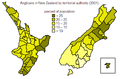 Anglicans in NZ.png 574 × 376; 20 KB
-
 Map of AM Network frequencies.png 398 × 563; 79 KB
-
 Map of Coast FM frequencies.png 399 × 563; 79 KB
-
 Map of Easy Mix frequencies.png 398 × 563; 79 KB
-
 Map of Flava frequencies.png 398 × 563; 78 KB
-
 Map of George FM frequencies.png 398 × 563; 79 KB
-
 Map of Hokonui frequencies.png 398 × 563; 79 KB
-
 Map of Life FM frequencies.png 399 × 563; 78 KB
-
 Map of Mai FM frequencies.png 398 × 563; 78 KB
-
 Map of Mix frequencies.png 398 × 563; 79 KB
-
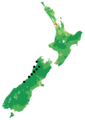
 Map of Newstalk ZB.png 398 × 563; 77 KB
-
 Map of Pacific Media Network frequencies.png 399 × 563; 78 KB
-
 Map of Port FM frequencies.png 398 × 563; 79 KB
-
 Map of Radio Live.png 398 × 563; 77 KB
-
 Map of Radio Sport frequencies.png 398 × 563; 78 KB
-
 Map of Rhema frequencies.png 399 × 563; 77 KB
-
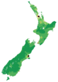
 Map of RNZ National relays.png 399 × 563; 80 KB
-
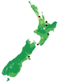
 Map of RNZ National.png 399 × 563; 76 KB
-
 Map of Star frequencies.png 398 × 563; 78 KB
-
 Map of TAB Trackside Radio frequencies.png 398 × 563; 77 KB
-
 Map of The Sound frequencies.png 398 × 563; 78 KB
-
 New Zealand electorate population change, 2018 census.svg 2,000 × 1,414; 1.98 MB
-
 New Zealand Population Density (The Hits).png 398 × 563; 77 KB
-
 Population density of New Zealand regions.png 3,249 × 2,655; 303 KB


.png)
