Category:Dent de Lys
| Object location | | View all coordinates using: OpenStreetMap |
|---|
mountain in the Bernese Alps  | |||||
| Upload media | |||||
| Instance of | |||||
|---|---|---|---|---|---|
| Part of |
| ||||
| Made from material | |||||
| Location | |||||
| Mountain range | |||||
| Topographic prominence |
| ||||
| Elevation above sea level |
| ||||
 | |||||
Media in category "Dent de Lys"
The following 64 files are in this category, out of 64 total.
-
 2013-05-07 Friburgo (Foto Dietrich Michael Weidmann) 029.JPG 3,872 × 2,592; 3.01 MB
-
 Alpes20220702104147.jpg 4,032 × 3,024; 5.95 MB
-
 Alpine Pasqueflower - Pulsatilla alpina (14291810736).jpg 3,456 × 5,184; 4.35 MB
-
 Alpine Pasqueflower - Pulsatilla alpina (14314944095).jpg 5,184 × 3,456; 4.35 MB
-
 Alpine Pasqueflower - Pulsatilla alpina (14314969285).jpg 5,184 × 3,456; 4.04 MB
-
 At the Col de Lys (14128482177).jpg 5,184 × 3,456; 6.6 MB
-
 Clusius' Gentian - Gentiana clusii (14291836146).jpg 5,184 × 3,456; 5.67 MB
-
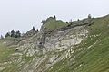
 Col soladier.jpg 9,974 × 3,806; 35.43 MB
-
 Dent and Col de Lys seen from col de soladier.jpg 882 × 679; 630 KB
-
 Dent de Lys (15088122173).jpg 5,184 × 3,456; 5.22 MB
-
 Dent de Lys seen from Le Molard (13954363962).jpg 3,456 × 5,184; 6.66 MB
-
 Dent de Lys seen from Le Molard (13957567615).jpg 5,184 × 3,456; 6.07 MB
-
 Dent de Lys seen from Le Molard - panoramio.jpg 5,184 × 3,456; 6.79 MB
-
 Dent de Lys vue depuis la crête.jpg 2,848 × 4,288; 4.86 MB
-
 Dent de Lys, Le Moléson and Dent de Corjon (42951098990).jpg 5,184 × 3,456; 4.37 MB
-
 Dent de Lys.jpg 1,752 × 2,627; 4.71 MB
-
-
 Le portrait d'une étagne.jpg 3,840 × 5,760; 12.54 MB
-
 Les pléiades 66.jpg 3,056 × 4,592; 11.9 MB
-
 Narcissus radiiflorus (14128175220).jpg 3,456 × 5,184; 9.03 MB
-
 Narcissus radiiflorus (14128266397).jpg 5,184 × 3,456; 11.46 MB
-
 Narcissus radiiflorus (14128357887).jpg 5,184 × 3,456; 10.48 MB
-
 Narcissus radiiflorus (14128368167).jpg 5,184 × 3,456; 9.16 MB
-
 Narcissus radiiflorus (14291618146).jpg 5,184 × 3,456; 10.17 MB
-
 Narcissus radiiflorus (14291677886).jpg 5,184 × 3,456; 10.94 MB
-
 Narcissus radiiflorus (14311478051).jpg 5,184 × 3,456; 8.38 MB
-
 Narcissus radiiflorus (14313029752).jpg 3,456 × 5,184; 10.16 MB
-
 Narcissus radiiflorus (14314195804).jpg 5,184 × 3,456; 8.59 MB
-
 Narcissus radiiflorus (14314894055).jpg 5,184 × 3,456; 4.33 MB
-
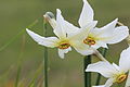 Narcissus radiiflorus (14314938675).jpg 5,184 × 3,456; 4.22 MB
-
 Narcissus radiiflorus (14334971273).jpg 5,184 × 3,456; 9.38 MB
-
 Near the Col de Lys (14128267159).jpg 5,184 × 3,456; 8.68 MB
-
 Near the Col de Lys (14128306200).jpg 5,184 × 3,456; 8.9 MB
-
 Near the Col de Lys (14128332607).jpg 5,184 × 3,456; 10.67 MB
-
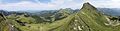
 Panoramic view at En Lys (14321042212).jpg 16,967 × 2,511; 46.49 MB
-
 Panoramic view at the Col de Lys (14136234128).jpg 10,121 × 4,118; 52.85 MB
-
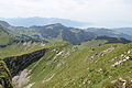
 Panoramic view from Mys Derrey (14697516559).jpg 15,763 × 4,090; 70.2 MB
-
 Panoramic view from Mys Derrey - panoramio.jpg 13,881 × 3,601; 23.38 MB
-
 Panoramic view from the Col de Lys - panoramio (1).jpg 18,104 × 2,508; 17.7 MB
-
 Panoramic view from the Col de Lys - panoramio.jpg 14,498 × 2,623; 18.63 MB
-
 Panoramic view from the Col de Soladier - panoramio.jpg 19,337 × 2,111; 19.59 MB
-
 Panoramic view from the Dent de Lys (14881705084).jpg 17,936 × 4,639; 97.93 MB
-
 Panoramic view from the Dent de Lys (14904815613).jpg 17,248 × 4,495; 93.6 MB
-
 Panoramic view from the Dent de Lys - panoramio (1).jpg 13,903 × 3,596; 23.66 MB
-
 Panoramic view from the Dent de Lys - panoramio (2).jpg 13,851 × 3,609; 24.24 MB
-
 Panoramic view from the Dent de Lys - panoramio.jpg 14,524 × 3,442; 23.99 MB
-
 Panoramic view near Le Pralet - panoramio.jpg 12,720 × 2,386; 14.28 MB
-
 Panoramic view near Mys Derrey (14904803023).jpg 20,796 × 3,629; 77.46 MB
-
 Panoramic view near Mys Derrey - panoramio (1).jpg 16,927 × 2,953; 22.02 MB
-
 Panoramic view near Mys Derrey - panoramio.jpg 15,576 × 3,209; 22.02 MB
-
 Panoramic view near the Dent de Lys - panoramio.jpg 15,532 × 3,219; 21.75 MB
-
 Pedicularis foliosa (14314951045).jpg 3,456 × 5,184; 4.88 MB
-
 Ridge up to the Dent de Lys (14891815351).jpg 5,184 × 3,456; 8.11 MB
-
 Rochers de Naye, Mont Grange and Dent de Lys (15880120411).jpg 5,184 × 3,456; 3.84 MB
-
 Rocks at the Dent de Lys (14873140376).jpg 5,184 × 3,456; 8.99 MB
-
 Scenic view near the Col de Soladier - panoramio (22).jpg 5,184 × 3,456; 6.52 MB
-
 Scenic view near the Col de Soladier - panoramio (27).jpg 5,184 × 3,456; 5.46 MB
-
 Teysachaux - Dent de lys.jpg 2,816 × 2,112; 2.29 MB
-
 Teysachaux and Moleson seen from the Dent de Lys (14708198540).jpg 5,184 × 3,456; 6.77 MB
-
 Trail towards the Dent de Lys (14128339009).jpg 3,456 × 5,184; 4.84 MB
-
 View from Mys Derrey (14128344879).jpg 5,184 × 3,456; 5.25 MB
-
 View On Dent De Lys (228681147).jpeg 2,048 × 1,268; 711 KB
-
 View on the Dent de Lys near Le Berry (14708201100).jpg 5,184 × 3,456; 6.31 MB
-
 Étagne à la Dent de Lys.jpg 5,760 × 3,840; 12.39 MB
_029.JPG)

.jpg)
.jpg)
.jpg)
.jpg)
.jpg)

.jpg)
.jpg)
.jpg)


.jpg)


.jpg)
.jpg)
.jpg)
.jpg)
.jpg)
.jpg)
.jpg)
.jpg)
.jpg)
.jpg)
.jpg)
.jpg)
.jpg)
.jpg)
.jpg)
.jpg)
.jpg)
.jpg)
.jpg)
.jpg)
.jpg)

.jpg)
.jpg)
.jpg)
.jpeg)
.jpg)

.jpg)
.jpg)
.jpg)
.jpg)
.jpg)
.jpg)
.jpg)
.jpg)
.jpg)
.jpg)