Category:Dieppe maps
series of 16th-century world maps made in Dieppe, Seine-Maritime | |||||
| Upload media | |||||
| Subclass of | |||||
|---|---|---|---|---|---|
| Named after | |||||
| |||||
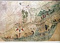
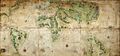
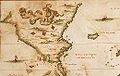
The Dieppe maps are a series of world maps produced in Dieppe, France, in the 1540s, 1550s and 1560s. They are large hand-produced maps, commissioned for wealthy and royal patrons, including Henry II of France and Henry VIII of England. The Dieppe school of cartographers included Pierre Desceliers, Johne Rotz, Guillaume Le Testu, Guillaume Brouscon and Nicholas Desliens.
Subcategories
This category has the following 3 subcategories, out of 3 total.
Media in category "Dieppe maps"
The following 8 files are in this category, out of 8 total.
-
 Australia first map.jpg 3,604 × 2,696; 3.81 MB
-
 Botany bay vallard.jpg 290 × 185; 47 KB
-
 CANADA MAP 1542 HARLEYENNE.jpg 2,366 × 1,690; 1.23 MB
-
 Description hidrografique de la France 1627.jpg 406 × 600; 66 KB
-
 Harleian.jpg 4,159 × 1,935; 1.61 MB
-
 Nicolas Desliens detail of Java la Grande 16th century.jpg 519 × 327; 40 KB
-
 Nicolas Desliens Map (1566).jpg 2,496 × 1,504; 1.23 MB
-
 Nicolas Desliens1.JPG 12,340 × 7,358; 15.74 MB


.jpg)
