Category:Dinedor
village in United Kingdom | |||||
| Upload media | |||||
| Instance of | |||||
|---|---|---|---|---|---|
| Location | Herefordshire, West Midlands, England | ||||
 | |||||
English: Dinedor is a hill, village and civil parish in Herefordshire, England. Dinedor is situated south east of Hereford. The hilltop is the site of an Iron Age fort. (→Dinedor)

Subcategories
This category has the following 3 subcategories, out of 3 total.
Media in category "Dinedor"
The following 107 files are in this category, out of 107 total.
-

-
 Armorial Bearings of the BODENHAM family of Dynedor, Herefordshire.png 1,200 × 1,200; 933 KB
-
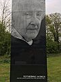
 Art work depicting Debbie Gittoes, Rotherwas, Hereford, UK 02.jpg 3,024 × 4,032; 3.14 MB
-
 Art work depicting Nora Foster, Rotherwas, Hereford, UK 01.jpg 3,024 × 4,032; 3.6 MB
-
 Art work depicting Sophie Dillon, Rotherwas, Hereford, UK 03.jpg 3,024 × 4,032; 3 MB
-
 Australian Red Indian encampment^ - geograph.org.uk - 1456056.jpg 640 × 426; 55 KB
-
 Autumn colours at Rotherwas - geograph.org.uk - 2619856.jpg 640 × 480; 83 KB
-
 B4399 - geograph.org.uk - 5217153.jpg 800 × 600; 240 KB
-
 B4399 at Dinedor Mill - geograph.org.uk - 1458901.jpg 640 × 480; 233 KB
-
 B4399 near Sink Green - geograph.org.uk - 1458895.jpg 640 × 480; 237 KB
-
 B4399 towards Holme Lacy - geograph.org.uk - 1458897.jpg 640 × 480; 240 KB
-
 Beech trees on Dinedor Hill - geograph.org.uk - 3951388.jpg 1,024 × 680; 428 KB
-
 Bend in the road - geograph.org.uk - 5217170.jpg 800 × 600; 236 KB
-
 Church Farm, Rotherwas - geograph.org.uk - 5066635.jpg 3,248 × 2,160; 2.16 MB
-
 Church Road, Dinedor - geograph.org.uk - 2404243.jpg 640 × 480; 82 KB
-
 Clay pots anyone^ - geograph.org.uk - 3597504.jpg 800 × 742; 312 KB
-
 Coldnose Road - geograph.org.uk - 5217175.jpg 800 × 600; 188 KB
-
 Dinedor entrance sign - geograph.org.uk - 2404223.jpg 640 × 480; 91 KB
-
 Dinedor Hill - geograph.org.uk - 1165286.jpg 640 × 480; 82 KB
-
 Dinedor Hill - geograph.org.uk - 3563552.jpg 1,024 × 768; 126 KB
-
 Dinedor HR2, UK - panoramio.jpg 2,596 × 1,947; 946 KB
-
 Dinedor Outdoor Centre - geograph.org.uk - 640572.jpg 640 × 480; 146 KB
-
 Dinedor Village Hall - geograph.org.uk - 1458916.jpg 640 × 480; 218 KB
-
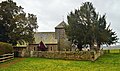
 Dinedor, Herefordshire, St Andrew - geograph.org.uk - 5908552.jpg 4,608 × 3,456; 5.28 MB
-
 Duck pond at Dinedor - geograph.org.uk - 640629.jpg 640 × 480; 169 KB
-
 Earthworks at Dinedor - geograph.org.uk - 1136772.jpg 640 × 426; 111 KB
-
 Earthworks at Dinedor - geograph.org.uk - 1136776.jpg 640 × 426; 101 KB
-
 Earthworks at Dinedor - geograph.org.uk - 159933.jpg 640 × 426; 107 KB
-
 Entrance to a stubble field, Dinedor - geograph.org.uk - 1136762.jpg 640 × 426; 81 KB
-
 Factories, Rotherwas (1) - geograph.org.uk - 5462726.jpg 640 × 443; 181 KB
-
 Factories, Rotherwas (3) - geograph.org.uk - 5462733.jpg 640 × 428; 93 KB
-
 Factories, Rotherwas (4) - geograph.org.uk - 5462734.jpg 640 × 433; 128 KB
-
 Farm between Dinedor and Dinedor Cross - geograph.org.uk - 640625.jpg 640 × 461; 109 KB
-
 Farm building near Dinedor Mill - geograph.org.uk - 1458905.jpg 640 × 480; 242 KB
-
 Fenced field boundary, Dinedor - geograph.org.uk - 1136779.jpg 426 × 640; 99 KB
-

-
 Garrison Field, Dinedor - geograph.org.uk - 1136782.jpg 640 × 426; 97 KB
-
 Glebe Farm and Dinedor church - geograph.org.uk - 1458919.jpg 640 × 480; 257 KB
-
 Glebe Farm, Dinedor - geograph.org.uk - 157960.jpg 640 × 426; 148 KB
-
 Hollywell Lane - geograph.org.uk - 1471697.jpg 640 × 480; 234 KB
-
 Houses in the evening sun - geograph.org.uk - 4651361.jpg 640 × 480; 133 KB
-
 George Robert Lewis - Hereford, from the Haywood, Noon (1815).jpg 1,504 × 1,142; 489 KB
-
 Hereford, Dynedor and the Malvern Hills Lewis.jpg 1,536 × 1,090; 418 KB
-
 Line of conifers by the Wye - geograph.org.uk - 1003560.jpg 640 × 480; 142 KB
-
 Locomotive on Rotherwas Trading Estate - geograph.org.uk - 5356751.jpg 1,024 × 576; 189 KB
-
 Meadows in the Wye valley - geograph.org.uk - 1136521.jpg 640 × 426; 79 KB
-
 Mind the gap - geograph.org.uk - 1004264.jpg 640 × 480; 150 KB
-
 Old Milepost by the B4399, near Barry's Cross, Dinedor parish (geograph 6048747).jpg 1,145 × 1,679; 369 KB
-
 Pastoral scene south of Dinedor - geograph.org.uk - 1458910.jpg 640 × 480; 259 KB
-
 Phone box at Dinedor Cross - geograph.org.uk - 640520.jpg 640 × 463; 110 KB
-
 Pillbox, Rotherwas - geograph.org.uk - 5462738.jpg 640 × 480; 217 KB
-
 Plots, Rotherwas Industrial Estate - geograph.org.uk - 5217182.jpg 800 × 600; 176 KB
-
 Power lines, Dinedor Court - geograph.org.uk - 5217151.jpg 800 × 600; 140 KB
-
 Railway bridge abutments at Rotherwas - geograph.org.uk - 4604519.jpg 3,089 × 2,048; 3.6 MB
-
 River Wye, Dinedor - geograph.org.uk - 5217174.jpg 800 × 600; 283 KB
-
 Road passing Rotherwas Chapel - geograph.org.uk - 5357452.jpg 800 × 600; 125 KB
-
 Road to Hereford at Barry's Cross - geograph.org.uk - 3412705.jpg 640 × 480; 139 KB
-
 Road to Hereford near Sink Green - geograph.org.uk - 3412697.jpg 640 × 480; 161 KB
-
 Road to Holme Lacy at Barry's Cross - geograph.org.uk - 3412710.jpg 640 × 480; 125 KB
-
 Road to Holme Lacy near Sink Green - geograph.org.uk - 3412700.jpg 640 × 480; 133 KB
-
 Rotherwas - geograph.org.uk - 2538064.jpg 1,280 × 856; 195 KB
-
 Rotherwas Chapel - geograph.org.uk - 2538063.jpg 856 × 1,280; 232 KB
-
 Rotherwas Chapel - geograph.org.uk - 5066448.jpg 1,694 × 1,579; 640 KB
-
 Rotherwas Chapel - geograph.org.uk - 5294506.jpg 1,600 × 1,200; 428 KB
-
 Rotherwas Chapel - geograph.org.uk - 5357455.jpg 768 × 1,024; 356 KB
-
 Rotherwas Chapel - geograph.org.uk - 5357458.jpg 768 × 1,024; 259 KB
-
 Rotherwas Chapel - geograph.org.uk - 5357459.jpg 1,024 × 768; 281 KB
-
 Rotherwas Industrial Estate - geograph.org.uk - 5217177.jpg 800 × 600; 254 KB
-
 Rotherwas Roundabout - geograph.org.uk - 2619853.jpg 640 × 480; 62 KB
-
 Rotherwas, aerial 2018 - geograph.org.uk - 5844266.jpg 800 × 533; 107 KB
-
 Rounding up the sheep 2 - geograph.org.uk - 1135506.jpg 426 × 640; 108 KB
-
 Salvage centre, Rotherwas, Hereford - geograph.org.uk - 3597499.jpg 800 × 600; 287 KB
-
 Salvage yard treasures - geograph.org.uk - 3597502.jpg 800 × 600; 276 KB
-
 Soil erosion - geograph.org.uk - 1135515.jpg 640 × 426; 128 KB
-
 Southern slope of Dinedor Hill - geograph.org.uk - 4280965.jpg 800 × 451; 189 KB
-
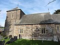
 St Andrew, Dinedor - geograph.org.uk - 4367412.jpg 5,625 × 3,325; 3.28 MB
-
 St Andrew, Dinedor - geograph.org.uk - 4367420.jpg 5,555 × 3,619; 1.9 MB
-
 St Andrew, Dinedor - geograph.org.uk - 4367433.jpg 5,511 × 4,319; 2.89 MB
-
 St Andrew, Dinedor - geograph.org.uk - 4367446.jpg 3,421 × 4,310; 2.49 MB
-
 St Andrew, Dinedor - geograph.org.uk - 4367458.jpg 5,525 × 3,225; 2.98 MB
-
 St Andrew, Dinedor, Herefordshire - geograph.org.uk - 5359751.jpg 1,754 × 1,170; 1.04 MB
-
 Stubble, Dinedor Court - geograph.org.uk - 5217171.jpg 800 × 600; 251 KB
-
 The B4399 at Dinedor - geograph.org.uk - 1136759.jpg 640 × 426; 62 KB
-
 The Hollow Farm, Dinedor - geograph.org.uk - 1136786.jpg 640 × 426; 81 KB
-
 The postbox at Dinedor Cross - geograph.org.uk - 640524.jpg 640 × 480; 122 KB
-
 The River Wye near Hereford - geograph.org.uk - 3724479.jpg 2,592 × 1,944; 1.49 MB
-
 The site of Rotherwas House - geograph.org.uk - 5357441.jpg 1,024 × 768; 250 KB
-
 The Wye valley at Dinedor - geograph.org.uk - 1136520.jpg 640 × 426; 106 KB
-
 The Wye valley viewed from Dinedor - geograph.org.uk - 1136523.jpg 640 × 426; 74 KB
-
 Track and footpath - geograph.org.uk - 1471705.jpg 640 × 480; 223 KB
-
 Trees above a valley, near Dinedor - geograph.org.uk - 1139709.jpg 424 × 640; 115 KB
-
 Trees at Rotherwas - geograph.org.uk - 5357446.jpg 768 × 1,024; 277 KB
-
 View from B4399 towards Dinedor Court - geograph.org.uk - 132048.jpg 640 × 480; 70 KB
-
 View to Dinedor Hill - geograph.org.uk - 1471701.jpg 640 × 480; 263 KB
-
 View to Sink Green and The Green - geograph.org.uk - 1004250.jpg 640 × 480; 139 KB
-
 Vincent Carey Road - geograph.org.uk - 5217179.jpg 800 × 600; 194 KB
-
 Vincent Carey Road - geograph.org.uk - 5217181.jpg 800 × 600; 176 KB
-
 Waterlogged crop, near Dinedor - geograph.org.uk - 1136788.jpg 640 × 426; 157 KB
-
 Wind pump near Dinedor - geograph.org.uk - 640621.jpg 640 × 480; 139 KB
-
 Windpump, Dinedor Hill - geograph.org.uk - 159928.jpg 640 × 426; 88 KB
-
-
 Afternoon stroll on Dinedor Hill - geograph.org.uk - 564717.jpg 640 × 453; 153 KB
-
 Arable field in a loop of The River Wye - geograph.org.uk - 1004266.jpg 640 × 480; 157 KB
-
 Corrugated barn at Dinedor - geograph.org.uk - 640627.jpg 640 × 480; 98 KB
-
 Country road from Hereford to Hoarwithy - geograph.org.uk - 627960.jpg 640 × 480; 149 KB
-
 Country Transport Systems - geograph.org.uk - 132028.jpg 640 × 480; 150 KB
-
 Farmland to the south of Dinedor - geograph.org.uk - 159931.jpg 640 × 426; 77 KB


_-_geograph.org.uk_-_5462726.jpg)
_-_geograph.org.uk_-_5462733.jpg)
_-_geograph.org.uk_-_5462734.jpg)


.jpg)


.jpg)


