Category:Distant views of Broad Law, Tweeddale
Media in category "Distant views of Broad Law, Tweeddale"
The following 34 files are in this category, out of 34 total.
-
 Broad Law from Lamb Knowe - geograph.org.uk - 413220.jpg 640 × 483; 84 KB
-
 Broad Law from Syart Law - geograph.org.uk - 1108522.jpg 640 × 427; 201 KB
-
 Cor Water from Annanhead Hill - geograph.org.uk - 1737202.jpg 800 × 530; 172 KB
-
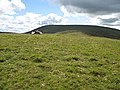
 Cramalt Craig cairn - geograph.org.uk - 320094.jpg 640 × 480; 70 KB
-
 Cramalt Craig view to Broad Law.jpg 640 × 394; 65 KB
-
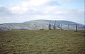
 Dun Law - geograph.org.uk - 1522246.jpg 640 × 480; 92 KB
-
 Fanks, Hearthstane - geograph.org.uk - 510938.jpg 640 × 480; 106 KB
-
 Glenheurie Rig - geograph.org.uk - 510935.jpg 640 × 480; 80 KB
-
 Great Knock - geograph.org.uk - 510644.jpg 640 × 480; 99 KB
-
 Hill countryside at Megget Reservoir - geograph.org.uk - 1111460.jpg 640 × 427; 179 KB
-
 Looking across Tweeddale - geograph.org.uk - 655929.jpg 640 × 480; 89 KB
-
 Nickies Knowe - geograph.org.uk - 559543.jpg 640 × 404; 57 KB
-
 Nickies Knowe, summit - geograph.org.uk - 467318.jpg 640 × 480; 66 KB
-
 On Hunt Law - geograph.org.uk - 16254.jpg 640 × 392; 36 KB
-
 On the northeast ridge of Craigdilly - geograph.org.uk - 1108793.jpg 640 × 418; 138 KB
-
 Ridge off Cramalt Craig - geograph.org.uk - 970703.jpg 640 × 359; 62 KB
-
 River Tweed at Hearthstane - geograph.org.uk - 38630.jpg 600 × 450; 153 KB
-

-
 Stottin Cleuch - geograph.org.uk - 1108482.jpg 640 × 427; 149 KB
-
 Summit of Dollar Law - geograph.org.uk - 16233.jpg 640 × 392; 39 KB
-
 Talla Cleuch Head - geograph.org.uk - 320111.jpg 640 × 480; 67 KB
-
 Talla East Side - geograph.org.uk - 559539.jpg 640 × 390; 44 KB
-

-
 The Tweed Valley from the summit of Wrae Hill - geograph.org.uk - 1755950.jpg 1,024 × 679; 281 KB
-
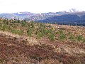
 Unplanted area, Peddrie Burn - geograph.org.uk - 932857.jpg 640 × 359; 59 KB
-
 View of Broad Law from Clyde Law - geograph.org.uk - 1446958.jpg 640 × 428; 64 KB
-
 Walking in the Southern Uplands - geograph.org.uk - 286272.jpg 640 × 480; 155 KB
-
 Alpine Tweeddale - geograph.org.uk - 246394.jpg 640 × 480; 42 KB
-
 Gool Knowe - geograph.org.uk - 354898.jpg 640 × 480; 188 KB
-
 Heartstane - geograph.org.uk - 246401.jpg 640 × 480; 47 KB
-
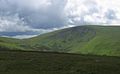
 Looking eastwards on the way to Broad Law - geograph.org.uk - 181833.jpg 640 × 480; 195 KB
-
 Summit, Cocklie Rig Head - geograph.org.uk - 52686.jpg 640 × 480; 276 KB
-
 Syart Farm. - geograph.org.uk - 354934.jpg 640 × 480; 69 KB
-
 Trig point, Pkyestone Hill - geograph.org.uk - 637373.jpg 640 × 480; 72 KB


