Category:Distant views of Swatte Fell
Media in category "Distant views of Swatte Fell"
The following 12 files are in this category, out of 12 total.
-
 Birnock Water - geograph.org.uk - 385919.jpg 480 × 640; 106 KB
-
 Blackhope - geograph.org.uk - 68511.jpg 640 × 411; 84 KB
-
 Broken Back from Croft Head - geograph.org.uk - 1063700.jpg 640 × 359; 52 KB
-
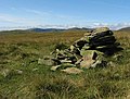 Cairn near Ferny Hill - geograph.org.uk - 550121.jpg 640 × 483; 138 KB
-
 East side of Blackhope. - geograph.org.uk - 68505.jpg 640 × 420; 54 KB
-
 Gap in the fence on Black Knowe Head - geograph.org.uk - 550211.jpg 640 × 480; 117 KB
-
 Gate, fence, and wall, Blue Cairn - geograph.org.uk - 385968.jpg 640 × 480; 95 KB
-
 Gates, walls and fences, Stot Knowe - geograph.org.uk - 385878.jpg 640 × 480; 86 KB
-
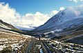
 Looking over the Devil's Beef Tub - geograph.org.uk - 564015.jpg 640 × 480; 62 KB
-

-
 Plantation, Pirnie Ridge - geograph.org.uk - 386012.jpg 640 × 480; 68 KB
-
 Valley of the Birnock Water - geograph.org.uk - 385939.jpg 640 × 480; 67 KB


