Category:Dolmen de la Pierre Courcoulée
| Object location | | View all coordinates using: OpenStreetMap |
|---|
|
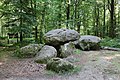
This building is classé au titre des monuments historiques de la France. It is indexed in the base Mérimée, a database of architectural heritage maintained by the French Ministry of Culture, under the references PA00090609
|
dolmen in Landéan, France  | |||||
| Upload media | |||||
| Instance of | |||||
|---|---|---|---|---|---|
| Part of | |||||
| Location | Landéan, Ille-et-Vilaine, Brittany, Q88521114, Metropolitan France, France | ||||
| Heritage designation | |||||
| Different from | |||||
 | |||||
Media in category "Dolmen de la Pierre Courcoulée"
The following 15 files are in this category, out of 15 total.
-
 . Dolmen de la pierre Courcoulé.jpg 794 × 516; 240 KB
-
 Dolmen de la pierre Courcoulée. (1).jpg 764 × 540; 249 KB
-
 Landéan - Pierre Courcoulée.jpg 3,648 × 2,736; 3.07 MB
-
 Landéan35Dolmen de la Pierre Courcoulée 01.jpg 3,000 × 2,000; 3.45 MB
-
 Landéan35Dolmen de la Pierre Courcoulée 02.jpg 3,000 × 2,000; 3.54 MB
-
 Landéan35Dolmen de la Pierre Courcoulée 03.jpg 3,000 × 2,000; 3.12 MB
-
 Landéan35Dolmen de la Pierre Courcoulée 04.jpg 3,000 × 2,000; 3.47 MB
-
 Landéan35Dolmen de la Pierre Courcoulée 05.jpg 3,000 × 2,000; 3.52 MB
-
 Landéan35Dolmen de la Pierre Courcoulée 06.jpg 3,000 × 2,000; 2.96 MB
-
 Landéan35Dolmen de la Pierre Courcoulée 07.jpg 3,000 × 2,000; 3.46 MB
-
 Landéan35Dolmen de la Pierre Courcoulée 08.jpg 3,000 × 2,000; 3.36 MB
-
 Landéan35Dolmen de la Pierre Courcoulée 09.jpg 3,000 × 2,000; 3.17 MB
-
 Landéan35Dolmen de la Pierre Courcoulée 10.jpg 3,000 × 2,000; 3.38 MB
-
 Landéan35Dolmen de la Pierre Courcoulée 11.jpg 3,000 × 2,000; 3.39 MB
-
 Landéan35Dolmen de la Pierre Courcoulée 12.jpg 2,000 × 3,000; 3.02 MB

.jpg)


