Category:Dolnooharská tabule
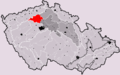
Čeština: Geomorfologický celek Dolnooharská tabule
 | |||||
| Upload media | |||||
| Instance of |
| ||||
|---|---|---|---|---|---|
| Part of | |||||
| Location |
| ||||
| Has part(s) | |||||
| Highest point | |||||
 | |||||
Subcategories
This category has the following 8 subcategories, out of 8 total.
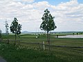
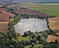
Media in category "Dolnooharská tabule"
The following 15 files are in this category, out of 15 total.
-
 Dolnooharska tabule CZ I6B-1.png 1,209 × 752; 49 KB
-
 Beřovice, golfové hřiště (3).jpg 3,072 × 2,304; 1.2 MB
-
 Draha u Líśťan.JPG 3,072 × 2,304; 565 KB
-
 IMG 0375m Velvary centrum.jpg 1,200 × 793; 429 KB
-
 Klobuky, skály.jpg 4,416 × 2,743; 2.94 MB
-
 Malnice Na Kamenici.jpg 3,072 × 2,304; 1.84 MB
-
 Pohled na Charvátce.JPG 3,264 × 1,568; 1.77 MB
-
 Pohled na jihozápad.JPG 3,256 × 1,900; 2.88 MB
-
 Prašný vrch.jpg 3,072 × 2,304; 2.55 MB
-
 Radešín.jpg 2,709 × 1,749; 1.16 MB
-
 Radešínek.JPG 2,879 × 1,105; 1.1 MB
-
 Zlonice (cropped).jpg 485 × 499; 108 KB
-
 Zlonice.jpg 900 × 600; 197 KB
-
 Šlapanice okres Kladno (cropped).jpg 215 × 173; 17 KB
-
 Šlapanice okres Kladno.jpg 900 × 601; 172 KB

.jpg)


.jpg)

.jpg)
