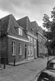
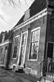
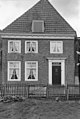
Category:Domineeswal 4, Blokzijl
| Object location | | View all coordinates using: OpenStreetMap |
|---|
building in Steenwijkerland, Netherlands  | |||||
| Upload media | |||||
| Instance of | |||||
|---|---|---|---|---|---|
| Location | Blokzijl, Overijssel, Netherlands | ||||
| Street address |
| ||||
| Located on street |
| ||||
| Heritage designation |
| ||||
 | |||||
|
This is a category about rijksmonument number 10452
|
| Address |
|
Media in category "Domineeswal 4, Blokzijl"
The following 7 files are in this category, out of 7 total.
-
 Blokzijl 109.JPG 3,264 × 2,448; 1.89 MB
-
 Detail woonhuis - Blokzijl - 20036445 - RCE.jpg 804 × 1,200; 226 KB
-
 Domineeswal 4 Blokzijl.jpg 2,736 × 3,648; 836 KB
-
 Overzicht - Blokzijl - 20036444 - RCE.jpg 1,200 × 804; 266 KB
-
 Overzicht - Blokzijl - 20036448 - RCE.jpg 804 × 1,200; 188 KB
-
 Voorgevel - Blokzijl - 20036446 - RCE.jpg 803 × 1,200; 224 KB
-
 Voorgevel - Blokzijl - 20036449 - RCE.jpg 805 × 1,200; 200 KB


