Category:Donatsturm (Freiberg)
| Object location | | View all coordinates using: OpenStreetMap |
|---|
| (Wikidata) |
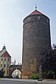
tower in Freiberg, Germany  | |||||
| Upload media | |||||
| Instance of | |||||
|---|---|---|---|---|---|
| Location | Freiberg, Mittelsachsen, Saxony, Germany | ||||
| Street address |
| ||||
| Heritage designation | |||||
| Inception |
| ||||
| Height |
| ||||
 | |||||
Subcategories
This category has the following 2 subcategories, out of 2 total.
D
- Donatstor (Freiberg) (11 F)
V
Media in category "Donatsturm (Freiberg)"
The following 66 files are in this category, out of 66 total.
-
 02969-Freiberg-1903-Donatsturm-Brück & Sohn Kunstverlag.jpg 1,000 × 1,551; 461 KB
-
 02979-Freiberg-1903-Donatsturm-Brück & Sohn Kunstverlag.jpg 1,000 × 1,537; 530 KB
-
 04622-Freiberg-1903-Donatsturm-Brück & Sohn Kunstverlag.jpg 1,512 × 1,000; 480 KB
-
 05502-Freiberg-1904-Donatsgasse mit Donatsturm-Brück & Sohn Kunstverlag.jpg 1,000 × 1,533; 495 KB
-
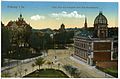
 06037-Freiberg-1905-Blick vom Petriturm auf die Stadt-Brück & Sohn Kunstverlag.jpg 1,491 × 1,000; 636 KB
-
 09549-Freiberg-1908-Der Wächter der Stadt-Brück & Sohn Kunstverlag.jpg 1,000 × 1,502; 630 KB
-
 10431-Freiberg-1908-Blick über Freiberg-Brück & Sohn Kunstverlag.jpg 1,516 × 1,000; 578 KB
-
 10433-Freiberg-1908-Blick auf Donatstum und Altstadt-Brück & Sohn Kunstverlag.jpg 1,516 × 1,000; 646 KB
-
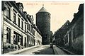 15628-Freiberg-1913-Donatsgasse und Donatsturm-Brück & Sohn Kunstverlag.jpg 1,519 × 1,000; 577 KB
-

-

-
 170217FreibergDonatsturm.jpg 1,941 × 2,659; 2.28 MB
-
 18063-Freiberg-1914-Blick auf Freiberg vom Jakobikirchturm-Brück & Sohn Kunstverlag.jpg 1,488 × 1,000; 546 KB
-
-
 18655-Freiberg-1915-verschiedene Stadtansichten-Brück & Sohn Kunstverlag.jpg 1,522 × 1,000; 687 KB
-
 18795-Freiberg-1915-Blick vom Jakobikirchturm-Brück & Sohn Kunstverlag.jpg 1,537 × 1,000; 722 KB
-
 18800-Freiberg-1915-verschiedene Ansichten-Brück & Sohn Kunstverlag.jpg 1,541 × 1,000; 627 KB
-
 20060803010DR Freiberg Donatsturm mit Stadttor.jpg 1,715 × 2,500; 2.56 MB
-
 20060803015DR Freiberg Donatsturm mit Stadttor.jpg 1,714 × 2,460; 2.45 MB
-
 21608-Freiberg-1920-Donatsgasse mit Donatsturm-Brück & Sohn Kunstverlag.jpg 1,519 × 1,000; 656 KB
-
 21613-Freiberg-1920-Donatsturm-Brück & Sohn Kunstverlag.jpg 1,000 × 1,516; 620 KB
-
 21631-Freiberg-1920-Blick auf Freiberg-Brück & Sohn Kunstverlag.jpg 1,545 × 1,000; 662 KB
-
 33008-Freiberg-2005-Ansichten, mehrteilig-Brück & Sohn Kunstverlag.jpg 3,512 × 2,500; 4.43 MB
-
 BlickzumDonatsturm.jpg 2,020 × 1,347; 702 KB
-
 Bundesarchiv Bild 183-37540-0004, Freiberg, Donatsturm.jpg 647 × 800; 61 KB
-
 Donatsturm Freiberg 01.JPG 3,232 × 3,232; 3.76 MB
-
 Donatsturm Freiberg 02.JPG 3,232 × 3,232; 4.19 MB
-
 Donatsturm Freiberg 03.JPG 3,232 × 3,232; 3.54 MB
-
 Donatsturm Freiberg 04.JPG 3,240 × 4,320; 4.93 MB
-
 Donatsturm Freiberg 06.JPG 3,240 × 4,320; 5 MB
-
 Donatsturm Freiberg 07.JPG 4,320 × 3,240; 5.71 MB
-
 Donatsturm Freiberg 08.JPG 2,560 × 1,920; 2.77 MB
-
 Donatsturm Freiberg 09.JPG 1,920 × 2,560; 2.16 MB
-
 Donatsturm Freiberg 10.JPG 2,560 × 1,920; 2.83 MB
-
 Donatsturm Freiberg 11.JPG 3,240 × 4,320; 4.94 MB
-
 Donatsturm Freiberg.jpg 2,319 × 3,478; 3.03 MB
-
 Donatsturm in der Altstadt von Freiberg 2H1A4721WI.jpg 2,498 × 3,620; 1.71 MB
-
 Eintracht bricht Not-Donatsturm (6065669489).jpg 12,085 × 3,168; 5.02 MB
-
 FG-Donatsturm.jpg 1,329 × 2,004; 673 KB
-
 FGDonatsturm.jpg 363 × 523; 58 KB
-
 Fotothek df ps 0002703 Befestigungsanlagen ^ Stadttürme.jpg 796 × 820; 201 KB
-
 Fotothek df ps 0002704 Befestigungsanlagen ^ Stadttürme.jpg 797 × 820; 188 KB
-
 Freiberg Stadtmauer am Donatstor.JPG 4,320 × 3,240; 3.92 MB
-
 Freiberg, An der Nikolaikirche, Aschegasse.JPG 3,456 × 5,184; 3.97 MB
-
 Freiberg, de Donatsturm Dm09200594 IMG 8106 2018-08-14 12.03.jpg 5,250 × 3,537; 10.61 MB
-
 Freiberg, die Kesselgasse, Blick zum Donatsturm.JPG 3,456 × 4,780; 3.41 MB
-
 Freiberg, Donatsgasse, Donatsturm-20150722-001.jpg 3,264 × 4,928; 11.5 MB
-
 Freiberg, Donatsturm und Donatstor - panoramio.jpg 2,272 × 3,408; 3.51 MB
-
 Freiberg, Donatsturm von Süden, 001.jpg 4,928 × 3,264; 8.91 MB
-
 Freiberg, Donatsturm, 09-2014, 001.jpg 4,928 × 3,264; 10.68 MB
-
 Freiberg, Donatsturm, Stadtseite, 08-2014-001.jpg 3,044 × 4,596; 8.92 MB
-
 Freiberg, Donatsturm-001.jpg 3,264 × 4,928; 12.21 MB
-
 Freiberg, Donatsturm-002.jpg 3,264 × 4,928; 13.17 MB
-
 Freiberg, Donatsturm-003.jpg 3,261 × 4,923; 9.68 MB
-
 Freiberg, Donatsturm-004.jpg 3,264 × 4,928; 8.29 MB
-
 Freiberg, Donatsturm-005.jpg 3,264 × 4,928; 8.8 MB
-
 Freiberg, Donatsturm-006.jpg 3,264 × 4,928; 8.48 MB
-
 Freiberg, Donatsturm-007.jpg 3,264 × 4,928; 9.43 MB
-
 Freiberg, Stadtbefestigung, Donatsturm-20150722-001.jpg 4,086 × 2,706; 8.27 MB
-
 Freiberg, Stadtbefestigung, Donatsturm-20150722-002.jpg 4,434 × 3,133; 10.01 MB
-
 Freiberg, Stadtbefestigung, Donatsturm-20150722-003.jpg 3,264 × 4,928; 10.88 MB
-
 Freiberg, Stadtmauer am Donatsturm-001.jpg 3,264 × 4,928; 10.39 MB
-
 Freiberg, Stadtmauer am Donatsturm-002.jpg 4,928 × 3,264; 10.22 MB
-
 Freiberg, Stadtmauer am Donatsturm-003.jpg 4,928 × 3,264; 9.88 MB
-
 Freibergdonatsturm.jpg 2,115 × 3,172; 3.77 MB
-
 KDFG 09200594 Donatsring Donatsturm Lvt.JPG 4,270 × 3,444; 4.2 MB


.jpg)