Category:Doopsgezinde kerk (Blokzijl)
| Object location | | View all coordinates using: OpenStreetMap |
|---|
church in Blokzijl, Netherlands  | |||||
| Upload media | |||||
| Instance of | |||||
|---|---|---|---|---|---|
| Location | Blokzijl, Overijssel, Netherlands | ||||
| Street address |
| ||||
| Located on street |
| ||||
| Heritage designation |
| ||||
| Religion or worldview | |||||
 | |||||
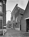
Nederlands: Doopsgezinde Kerk Het Lam, Blokzijl
|
This is a category about rijksmonument number 507462
|
| Address |
|
Media in category "Doopsgezinde kerk (Blokzijl)"
The following 12 files are in this category, out of 12 total.
-
 Breestraat 2 het Lam Blokzijl.jpg 2,736 × 3,648; 858 KB
-
 Doopsgezinde Vermaning "Het Lam" Blokzijl.JPG 3,448 × 4,592; 2.86 MB
-
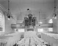 Interieur naar het noorden - Blokzijl - 20036410 - RCE.jpg 1,200 × 953; 141 KB
-
 Interieur naar het noorden - Blokzijl - 20036411 - RCE.jpg 1,200 × 953; 153 KB
-
 Interieur naar het zuiden - Blokzijl - 20036412 - RCE.jpg 1,200 × 960; 156 KB
-
 Interieur naar het zuiden - Blokzijl - 20036413 - RCE.jpg 1,200 × 955; 131 KB
-
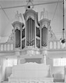 Interieur orgel - Blokzijl - 20036414 - RCE.jpg 953 × 1,200; 134 KB
-
 Interieur preekstoel - Blokzijl - 20036415 - RCE.jpg 1,181 × 1,200; 174 KB
-
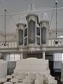 Interieur, aanzicht orgel, orgelnummer 191 - Blokzijl - 20370723 - RCE.jpg 898 × 1,200; 149 KB
-
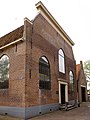
 Noordgevel - Blokzijl - 20036407 - RCE.jpg 955 × 1,200; 265 KB
-
 Noordgevel - Blokzijl - 20036408 - RCE.jpg 953 × 1,200; 270 KB
-
 Oostgevel - Blokzijl - 20036409 - RCE.jpg 960 × 1,200; 297 KB


