Category:Dore Holm
| Object location | | View all coordinates using: OpenStreetMap |
|---|
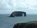
small islet off the south coast of Esha Ness, in the west of Mainland, Shetland Islands, Scotland, UK  | |||||
| Upload media | |||||
| Instance of | |||||
|---|---|---|---|---|---|
| Location | Shetland Islands, Scotland | ||||
| Located in or next to body of water | |||||
 | |||||
Media in category "Dore Holm"
The following 20 files are in this category, out of 20 total.
-

-
 Dore Holm - Black's picturesque tourist of Scotland.jpg 1,524 × 1,612; 662 KB
-
 Dore Holm - geograph.org.uk - 2033576.jpg 2,560 × 1,920; 1.85 MB
-
 Dore Holm - geograph.org.uk - 5924367.jpg 800 × 600; 488 KB
-
 Dore Holm - geograph.org.uk - 6182145.jpg 1,600 × 1,172; 205 KB
-
 Dore Holm - geograph.org.uk - 6184271.jpg 1,600 × 1,075; 180 KB
-
 Dore Holm - The Drinking Horse - geograph.org.uk - 2588397.jpg 1,171 × 1,000; 780 KB
-
 Dore Holm 5829.jpg 2,048 × 1,536; 550 KB
-
 Dore Holm from a safe distance - geograph.org.uk - 5839640.jpg 5,472 × 3,648; 3.37 MB
-
 Dore Holm IMG 1519 (34071377861).jpg 4,208 × 2,314; 2.69 MB
-
 Dore Holm IMG 4606 (21899978530).jpg 4,212 × 2,335; 2.87 MB
-
 Dore Holm, Shetland - geograph.org.uk - 6256.jpg 640 × 480; 63 KB
-
 Dore Holme - geograph.org.uk - 6181939.jpg 1,600 × 1,200; 447 KB
-
 Esha Ness 08.jpg 4,080 × 3,072; 3.27 MB
-
 Perforated island - geograph.org.uk - 3982516.jpg 2,048 × 1,536; 1.47 MB
-
 Sae Breck, Esha Ness - geograph.org.uk - 6262.jpg 640 × 479; 81 KB
-
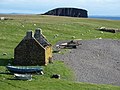 Stenness Fishing Station Böd.jpg 1,600 × 1,200; 1.87 MB
-
 The classic view of Dore Holm, Eshaness - geograph.org.uk - 3008411.jpg 800 × 534; 127 KB
-
 View to Dore Holm - geograph.org.uk - 2588415.jpg 1,333 × 1,000; 1.2 MB
-
 West Loch - geograph.org.uk - 1307863.jpg 640 × 481; 91 KB


.jpg)
.jpg)


