Category:Dorfkirche (Gohlitz)
| Object location | | View all coordinates using: OpenStreetMap |
|---|
church building in Brandenburg state, Germany   | |||||
| Upload media | |||||
| Instance of | |||||
|---|---|---|---|---|---|
| Location | Gohlitz, Nauen, Havelland District, Brandenburg, Germany | ||||
| Heritage designation | |||||
 | |||||
This is the category of the Brandenburger Baudenkmal (cultural heritage monument) with the ID 09150378 (Wikidata)
|
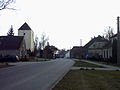
English: Church in Gohlitz, Nauen municipality, Havelland district, Brandenburg state, Germany. It is owned and used by a Lutheran congregation within the Evangelical Church of Berlin-Brandenburg-Silesian Upper Lusatia, a united Protestant church body of Calvinist, Lutheran and united congregations.
Deutsch: Dorfkirche in Gohlitz, Stadt Nauen, Landkreis Havelland, Land Brandenburg, Deutschland. Sie gehört und dient einer lutherischen Gemeinde der unierten Evangelischen Kirche Berlin-Brandenburg-Schlesische Oberlausitz.
Français : Église de Gohlitz, ville de Nauen, arrondissement Pays de la Havel, état fédéral de Brandebourg, Allemagne
Media in category "Dorfkirche (Gohlitz)"
The following 4 files are in this category, out of 4 total.
-
 Dorfkirche gohlitz.JPG 1,600 × 1,200; 242 KB
-
 Gohlitz church 2015 S.jpg 2,688 × 1,520; 1.8 MB
-
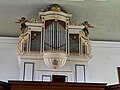 Grünegerg-Orgel Gohlitz.jpg 4,000 × 3,000; 1.39 MB
-
 Kirche Gohlitz.jpg 2,229 × 1,869; 2.28 MB

