Category:Dorfkirche (Tuchen)
| Object location | | View all coordinates using: OpenStreetMap |
|---|
church building in Brandenburg state, Germany   | |||||
| Upload media | |||||
| Instance of | |||||
|---|---|---|---|---|---|
| Location | Breydin, Barnim District, Brandenburg, Germany | ||||
| Heritage designation | |||||
 | |||||
This is the category of the Brandenburger Baudenkmal (cultural heritage monument) with the ID 09175307 (Wikidata)
|
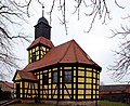
Deutsch: Die Dorfkirche (auch Hochzeitskirche) in Tuchen (zu Breydin), Mark Brandenburg, gehört und diente einer lutherischen Gemeinde der unierten Evangelischen Kirche Berlin-Brandenburg-Schlesische Oberlausitz. Sie dient heute als Trauraum und Veranstaltungsraum.
English: The former Village Church in Tuchen (a locality of Breydin), March of Brandenburg, Germany, was owned and used by a Lutheran congregation within the Evangelical Church of Berlin-Brandenburg-Silesian Upper Lusatia, a united Protestant church body of Calvinist, Lutheran and united congregations.
Subcategories
This category has only the following subcategory.
I
Media in category "Dorfkirche (Tuchen)"
The following 4 files are in this category, out of 4 total.
-
 Dorfkirche Tuchen 2015 ESE.jpg 2,592 × 1,944; 2.09 MB
-
 Dorfkirche Tuchen S 2015.JPG 2,592 × 1,944; 2.19 MB
-
 Dorfkirche-tuchen-rr.jpg 3,892 × 3,619; 4.48 MB
-
 Hochzeitskirche-tuchen-rr.jpg 2,430 × 1,988; 1.95 MB


