Category:Dorfkirche Ahrensfelde
| Object location | | View all coordinates using: OpenStreetMap |
|---|
church building in Brandenburg state, Germany  | |||||
| Upload media | |||||
| Instance of | |||||
|---|---|---|---|---|---|
| Location | Ahrensfelde, Barnim District, Brandenburg, Germany | ||||
| Architectural style | |||||
| Heritage designation | |||||
 | |||||
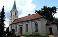
Deutsch: Kirche von Ahrensfelde, Landkreis Barnim, Land Brandenburg, Deutschland
English: Ahrensfelde church, Barnim district, Brandenburg state, Germany
This is the category of the Brandenburger Baudenkmal (cultural heritage monument) with the ID 09175013 (Wikidata)
|
Deutsch: Weitere Kirchen finden sich unter: Liste der Kirchengebäude im Landkreis Barnim
English: More churches can be found under: Complete list of churches in Barnim district (German)
Subcategories
This category has only the following subcategory.
I
Media in category "Dorfkirche Ahrensfelde"
The following 9 files are in this category, out of 9 total.
-
 Ahrensfelde 2001.jpg 200 × 250; 177 KB
-
 Ahrensfelde Dorfkirche.JPG 3,230 × 3,220; 1.45 MB
-
 Ahrensfelde Kirche - Glockenstube.JPG 2,592 × 1,944; 1.07 MB
-
 Ahrensfelde tram 2016 I.jpg 3,648 × 2,736; 4.7 MB
-

-
 Clp 20060923 Dorfkirche Ahrensfelde.jpg 2,592 × 1,944; 1.12 MB
-
 Dorfkirche Ahrensfelde 02.jpg 800 × 520; 183 KB
-
 Dorfkirche Ahrensfelde.jpg 1,542 × 2,931; 2.7 MB
-
 Kirche-Ahrensfelde.jpg 4,608 × 3,456; 4.1 MB


