Category:Dorfkirche Altkünkendorf
| Object location | | View all coordinates using: OpenStreetMap |
|---|
church building in Angermünde, Brandenburg state, Germany  | |||||
| Upload media | |||||
| Instance of | |||||
|---|---|---|---|---|---|
| Location | Altkünkendorf, Angermünde, Uckermark District, Brandenburg, Germany | ||||
| Heritage designation | |||||
 | |||||
This is the category of the Brandenburger Baudenkmal (cultural heritage monument) with the ID 09130259 (Wikidata)
|
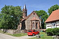
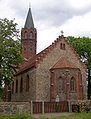
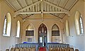
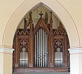
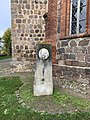
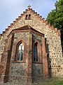
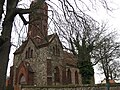
Deutsch: Die Dorfkirche in Altkünkendorf, Mark Brandenburg, gehört und dient einer Gemeinde der unierten Evangelischen Kirche Berlin-Brandenburg-Schlesische Oberlausitz. Die Kirche entstand um 1300 und wurde Mitte des 19. Jh.s gotisierend überformt und erhielt einen Turmaufsatz.
English: The Village Church in Altkünkendorf, March of Brandenburg, Germany, is owned and used by a congregation within the Evangelical Church of Berlin-Brandenburg-Silesian Upper Lusatia, a united Protestant church body of Calvinist, Lutheran and united congregations. The church was erected by 1300 but reshaped in Gothic forms in the mid-19th c., when also a spire was added.
Subcategories
This category has only the following subcategory.
I
Media in category "Dorfkirche Altkünkendorf"
The following 23 files are in this category, out of 23 total.
-
 2011-06-02-rbu-by-RalfR-025.jpg 4,288 × 2,848; 6.26 MB
-
 2011-06-02-rbu-by-RalfR-026.jpg 7,930 × 4,455; 10 MB
-
 2011-06-02-rbu-by-RalfR-027.jpg 2,848 × 4,288; 5.52 MB
-
 20200919 xl DSCN0307-Buchenwald-Grumsin-bei-Altkuenkendorf.JPG 4,608 × 3,456; 6.32 MB
-
 Altkuenkendorf church.jpg 1,350 × 1,770; 424 KB
-
 Altkünkendorf Dorfkirche 01.jpg 3,648 × 2,736; 2.72 MB
-
 Altkünkendorf Dorfkirche 02.jpg 3,648 × 2,752; 2.7 MB
-
 Altkünkendorf Dorfkirche 03.jpg 3,334 × 3,600; 3.34 MB
-
 Altkünkendorf Dorfkirche 04.jpg 4,000 × 2,561; 2.29 MB
-
 Altkünkendorf Dorfkirche 05.jpg 3,648 × 2,232; 1.94 MB
-
 Altkünkendorf Dorfkirche 06.jpg 3,600 × 3,248; 2.31 MB
-
 Dorfkirche Altkünkendorf Bildhauerdenkmal.jpg 3,024 × 4,032; 5.37 MB
-
 Dorfkirche Altkünkendorf Nordansicht.jpg 4,032 × 3,024; 4.16 MB
-
 Dorfkirche Altkünkendorf Nordwestansicht Turmgeschoss.jpg 3,024 × 4,032; 3.56 MB
-
 Dorfkirche Altkünkendorf Ostansicht.jpg 3,024 × 4,032; 4.08 MB
-
 Dorfkirche Altkünkendorf Querformat.jpg 4,032 × 3,024; 2.91 MB
-
 Dorfkirche Altkünkendorf Südostansicht mit Einfriedung.jpg 3,024 × 4,032; 2.8 MB
-
 Dorfkirche Altkünkendorf Südostansicht.jpg 4,032 × 3,024; 3.55 MB
-
 Dorfkirche Altkünkendorf Westportal.jpg 4,032 × 3,024; 4.51 MB
-
 Dorfkirche Altkünkendorf Westturm Nordwestansicht Erdgeschoss.jpg 3,024 × 4,032; 3.58 MB
-
 Dorfkirche Altkünkendorf Westturm Südostansicht.jpg 3,024 × 4,032; 3.29 MB
-
 Dorfkirche Altkünkendorf Westturm Westansicht.jpg 3,024 × 4,032; 2.3 MB
-
 DorfkircheAltkünkendorf.JPG 3,264 × 2,448; 2.86 MB


