Category:Dorfkirche Hohenkuhnsdorf
| Object location | | View all coordinates using: OpenStreetMap |
|---|
church building in Elbe-Elster district, Brandenburg state, Germany  | |||||
| Upload media | |||||
| Instance of | |||||
|---|---|---|---|---|---|
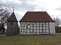
| Location | Hohenkuhnsdorf, Ahlsdorf (Schönewalde), Schönewalde, Elbe-Elster District, Brandenburg, Germany | ||||
| Street address |
| ||||
| Heritage designation | |||||
| Inception |
| ||||
| Religion or worldview | |||||
 | |||||
This is the category of the Brandenburger Baudenkmal (cultural heritage monument) with the ID 09135198 (Wikidata)
|
English: Pictures of the church in Hohenkuhnsdorf, Schönewalde municipality , Elbe-Elster district, Brandenburg state, Germany.
Deutsch: Ansichten der Kirche in Hohenkuhnsdorf, Stadt Schönewalde, Landkreis Elbe-Elster, Land Brandenburg, Deutschland.
Français : Photos de l'église à Hohenkuhnsdorf, ville de Schönewalde, arrondissement de Elbe-Elster, état fédéral de Brandebourg, Allemagne
Español: Vistas de la iglesia en Hohenkuhnsdorf, ciudad de Schönewalde, distrito de Elbe-Elster, estado federado de Brandeburgo, Alemania
Address:
Hohenkuhnsdorf 4, 04916 Schönewalde
Pages in category "Dorfkirche Hohenkuhnsdorf"
This category contains only the following page.
Media in category "Dorfkirche Hohenkuhnsdorf"
The following 11 files are in this category, out of 11 total.
-
 20150508650DR Hohenkuhnsdorf (Schönewalde) Dorfkirche.jpg 2,419 × 1,931; 3.34 MB
-
 20150508655DR Hohenkuhnsdorf (Schönewalde) Dorfkirche.jpg 2,498 × 1,851; 3.72 MB
-
 20150508660DR Hohenkuhnsdorf (Schönewalde) Dorfkirche.jpg 2,409 × 1,803; 3.2 MB
-
 Dorfkirche Hohenkuhnsdorf 2021 Fenster.jpg 3,648 × 4,864; 4.27 MB
-
 Dorfkirche Hohenkuhnsdorf 2021 Glockenturm.jpg 3,648 × 4,864; 5.63 MB
-
 Dorfkirche Hohenkuhnsdorf 2021 N.jpg 4,864 × 3,648; 4.97 MB
-
 Dorfkirche Hohenkuhnsdorf 2021 NW.jpg 4,864 × 3,648; 4.88 MB
-
 Dorfkirche Hohenkuhnsdorf 2021 Portal.jpg 3,648 × 4,864; 5.03 MB
-
 Dorfkirche Hohenkuhnsdorf 2021 SE.jpg 4,864 × 3,648; 4.62 MB
-
 Dorfkirche Hohenkuhnsdorf 2021 SW.jpg 4,864 × 3,648; 4.96 MB
-
 Kirche-Hohenkuhnsdorf.jpg 2,560 × 1,849; 3.82 MB
_Dorfkirche.jpg)
_Dorfkirche.jpg)
_Dorfkirche.jpg)


