Category:Dorfkirche Möglin
| Object location | | View all coordinates using: OpenStreetMap |
|---|
church building in Brandenburg state, Germany  | |||||
| Upload media | |||||
| Instance of | |||||
|---|---|---|---|---|---|
| Location | Möglin, Reichenow-Möglin, Märkisch-Oderland District, Brandenburg, Germany | ||||
| Street address |
| ||||
| Heritage designation | |||||
 | |||||
This is the category of the Brandenburger Baudenkmal (cultural heritage monument) with the ID 09180531 (Wikidata)
|
Deutsch: Bilder der Kirche in Möglin, Gemeinde Reichenow-Möglin, Landkreis Märkisch-Oderland, Land Brandenburg, Deutschland.
English: Pictures of the church in Möglin, Reichenow-Möglin municipality, Märkisch-Oderland district, Brandenburg state, Germany
Français : Photos de l'église à Möglin, commune de Reichenow-Möglin, arrondissement de Märkisch-Oderland, état fédéral de Brandebourg, Allemagne
Subcategories
This category has only the following subcategory.
I
Pages in category "Dorfkirche Möglin"
This category contains only the following page.
Media in category "Dorfkirche Möglin"
The following 6 files are in this category, out of 6 total.
-
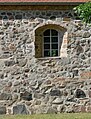 Dorfkirche Möglin 2023 Fenster.jpg 2,736 × 3,591; 2.62 MB
-
 Dorfkirche Möglin 2023 NE.jpg 2,736 × 3,515; 3.52 MB
-
 Dorfkirche Möglin 2023 SSE.jpg 3,648 × 2,736; 3.42 MB
-
 Dorfkirche Möglin 2023 Südportal.jpg 3,648 × 2,736; 3.33 MB
-
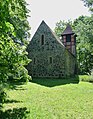
 Dorfkirche Möglin 2023 Turm.jpg 2,695 × 3,593; 2.04 MB
-
 Moeglin church.jpg 2,850 × 2,160; 961 KB


