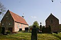
Category:Dorfkirche Woltzeten
| Object location | | View all coordinates using: OpenStreetMap |
|---|
| Upload media | |||||
| Instance of | |||||
|---|---|---|---|---|---|
| Location | Woltzeten, Krummhörn, Aurich, Lower Saxony, Germany | ||||
 | |||||
Media in category "Dorfkirche Woltzeten"
The following 4 files are in this category, out of 4 total.
-
 70652 Woltzeten Turm + Kirche v N.jpg 3,000 × 4,000; 4.94 MB
-
 70653 Woltzeten Kirche v N.jpg 4,000 × 3,000; 5.26 MB
-
 70654 Woltzeten Kirche v S.jpg 4,000 × 3,000; 4.9 MB
-
 ChurchWoltzeten.JPG 3,072 × 2,048; 2.95 MB


