Category:Dorpsstraat 32, Molenaarsgraaf
| NO WIKIDATA ID FOUND! Search for Dorpsstraat 32, Molenaarsgraaf on Wikidata | |
| Upload media |
| Object location | | View all coordinates using: OpenStreetMap |
|---|
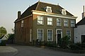
Nederlands: Afbeeldingen van de Dorpsstraat 32 in Molenaarsgraaf in de provincie Zuid-Holland in het westen van Nederland. Het is de voormalige Pastorie van de Nederlands Hervormde kerk in Molenaarsgraaf
|
This is a category about rijksmonument number 29953
|
Media in category "Dorpsstraat 32, Molenaarsgraaf"
The following 3 files are in this category, out of 3 total.
-
 Molenaarsgraaf RM Dorpsstraat 32.jpg 4,357 × 3,437; 5.02 MB
-
 Nederlands Hervormde Pastorie, aanzicht - Molenaarsgraaf - 20159868 - RCE.jpg 1,200 × 803; 167 KB
-
 Pastorie van de Nederlands Hervormde kerk Molenaarsgraaf - panoramio.jpg 2,671 × 1,748; 794 KB


