Category:Draught of the Cherokee Country
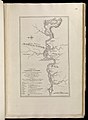
Map and details of Henry Timberlake's 1765 map, "Draught of the Cherokee Country."
Media in category "Draught of the Cherokee Country"
The following 11 files are in this category, out of 11 total.
-
-
 Chilhowee-timberlake-detail1.jpg 356 × 205; 40 KB
-
 Chota-timberlake-detail1.jpg 415 × 234; 59 KB
-
 Citico-timberlake-detail1.jpg 365 × 260; 46 KB
-
 Draught of the Cherokee Country.jpg 1,400 × 2,278; 609 KB
-
 Mialoquo-timberlake-detail1.jpg 326 × 225; 20 KB
-
 Tallassee-timberlake-detail1.jpg 372 × 216; 50 KB
-
 Timberlake-map-tanasi-1765.jpg 434 × 286; 44 KB
-
 Timberlake-map-toskegee.jpg 364 × 227; 25 KB
-
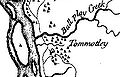 Tomotley-timberlake-detail1.jpg 314 × 202; 29 KB
-
 Toqua-timberlake-detail1.jpg 327 × 236; 32 KB
.jpg)


