Category:Drumry

area in Clydebank, West Dunbartonshire, Scotland, UK  | |||||
| Upload media | |||||
| Instance of | |||||
|---|---|---|---|---|---|
| Part of | |||||
| Location | West Dunbartonshire, Scotland | ||||
 | |||||
Subcategories
This category has the following 9 subcategories, out of 9 total.
C
- Clydebank BMX track (3 F)
D
- Drumry railway station (10 F)
- Drumry Road, Clydebank (6 F)
F
K
M
O
- Onslow Road, Clydebank (7 F)
Media in category "Drumry"
The following 45 files are in this category, out of 45 total.
-
 Array of houses in Drumry - geograph.org.uk - 608772.jpg 640 × 480; 73 KB
-
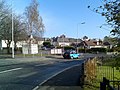
 Clarence Street, Clydebank - geograph.org.uk - 796992.jpg 640 × 480; 86 KB
-
 Clarence Street, Drumry - geograph.org.uk - 608748.jpg 640 × 480; 84 KB
-
 Clydebank from the air (geograph 5221055).jpg 640 × 480; 208 KB
-
 Clydebank K-Park - geograph.org.uk - 593391.jpg 640 × 480; 65 KB
-
 Cumbae Court, Clydebank - geograph.org.uk - 621857.jpg 640 × 480; 70 KB
-
 Drumry and Linnvale from the air (geograph 4687846).jpg 3,264 × 2,448; 3.61 MB
-
 Drumry at night - geograph.org.uk - 693324.jpg 640 × 480; 29 KB
-
 Drumry housing - geograph.org.uk - 608743.jpg 640 × 480; 106 KB
-
 Early morning sun over Drumry - geograph.org.uk - 589216.jpg 640 × 480; 48 KB
-
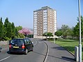
 Flats, Kirkoswald Drive (geograph 4786155).jpg 640 × 480; 112 KB
-

-
 Glasgow in the morning - geograph.org.uk - 681696.jpg 640 × 480; 34 KB
-
 Grass by Great Western Road - geograph.org.uk - 587632.jpg 640 × 480; 121 KB
-
 Grassland by Morar Road - geograph.org.uk - 789745.jpg 480 × 640; 113 KB
-
 Great Western Road from the air (geograph 5599799).jpg 640 × 480; 191 KB
-
 Housing in Drumry - geograph.org.uk - 593383.jpg 640 × 480; 62 KB
-
 Kirkoswald Drive, Drumry - geograph.org.uk - 831224.jpg 640 × 480; 71 KB
-
 Looking back to Clydebank from Drumry - geograph.org.uk - 668531.jpg 640 × 480; 54 KB
-
 Looking to Gleniffer View, Drumry - geograph.org.uk - 831500.jpg 640 × 480; 79 KB
-

-
 Looking to the Clydebank Titan Crane - geograph.org.uk - 689021.jpg 640 × 480; 39 KB
-
 Looking to Thor Ceramics from Drumry - geograph.org.uk - 726330.jpg 640 × 480; 56 KB
-
 Overcast sky over Drumry - geograph.org.uk - 759139.jpg 640 × 480; 43 KB
-
 Path to Drumry - geograph.org.uk - 689018.jpg 640 × 480; 29 KB
-
 Path to Great Western Road - geograph.org.uk - 593302.jpg 640 × 480; 46 KB
-
 Play park off Kirkoswald Drive (geograph 5350171).jpg 1,600 × 1,036; 296 KB
-
 Riddell Street, Drumry - geograph.org.uk - 831496.jpg 640 × 480; 60 KB
-

-
 Shops in Drumry - geograph.org.uk - 831236.jpg 640 × 480; 67 KB
-
 Snow thinly lying in Drumry - geograph.org.uk - 719659.jpg 640 × 480; 80 KB
-

-
 St Eunan's Church, Drumry - geograph.org.uk - 831515.jpg 640 × 480; 80 KB
-
 Sun rising over Drumry - geograph.org.uk - 667429.jpg 640 × 480; 50 KB
-
 Sunrise on a foggy morning - geograph.org.uk - 593299.jpg 640 × 480; 28 KB
-
 Tower Block UK photo cl1-27 (Clydebank Drumry 1983).jpg 2,599 × 1,728; 750 KB
-
 Typical Drumry housing - geograph.org.uk - 608763.jpg 640 × 480; 53 KB
-

-
 View across the Cleddans Burn wetland (geograph 5350669).jpg 1,600 × 996; 368 KB
-
 View south on Kilbowie Road - geograph.org.uk - 771913.jpg 640 × 480; 58 KB
-

-
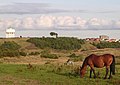 Water Tower plus Horse - geograph.org.uk - 48107.jpg 640 × 451; 77 KB
-
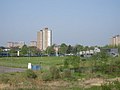
 Wild Grasses and Tower Blocks - geograph.org.uk - 48099.jpg 640 × 480; 132 KB
-
 World of Golf, Drumchapel - geograph.org.uk - 805245.jpg 640 × 480; 56 KB
-
 Youths smashing up a burnt out car - geograph.org.uk - 48096.jpg 640 × 455; 95 KB


.jpg)


.jpg)


.jpg)


.jpg)


.jpg)


.jpg)

.jpg)


