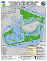
Category:Dutch Gap (Virginia)
 | |||||
| Upload media | |||||
| Instance of | |||||
|---|---|---|---|---|---|
| Location | Virginia | ||||
 | |||||
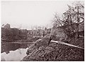
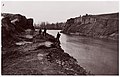
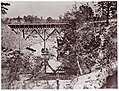
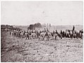
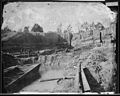
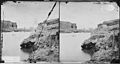
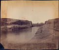
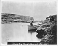
English: Dutch Gap is the site of a canal on the James River in Chesterfield County, Virginia that was built during the American Civil War.
Subcategories
This category has the following 2 subcategories, out of 2 total.
A
- A.M. Aiken House (4 F)
C
- Chesterfield Power Station (2 F)
Media in category "Dutch Gap (Virginia)"
The following 140 files are in this category, out of 140 total.
-
 10-inch seacoast mortars, Model 1841.jpg 3,868 × 2,348; 759 KB
-

-
 A Columbiad overlooking Farrar's Island near the Dutch Gap Canal.jpg 2,172 × 1,865; 2.33 MB
-
 Aiken's Landing on James River - NARA - 530540.jpg 3,000 × 1,349; 1.11 MB
-
 Aiken's Landing, James River - NARA - 530542.jpg 3,000 × 2,203; 1.51 MB
-
 Artillery at the Dutch Gap Artillery Range.jpg 631 × 413; 45 KB
-

-
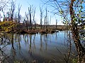
 Autumn Red Dutch Gap Conservation Area Chester VA 8747 (23388587673).jpg 4,320 × 3,240; 4.54 MB
-
 Autumn Red Dutch Gap Conservation Area Chester VA 8748 (23387168364).jpg 4,320 × 3,240; 5.07 MB
-
 Black Vulture bait cage.jpg 2,032 × 1,524; 1.17 MB
-
 BrookeRifle.jpg 1,955 × 1,349; 469 KB
-
 Butlers Canal, Dutch Gap LCCN2004660648.jpg 4,066 × 3,142; 1.49 MB
-
 Coal Ash Power Discharge Canal Dutch Gap Conservation Area Chester VA 8699 (23388535363).jpg 4,320 × 3,240; 4.19 MB
-

-
 Coal Ash Power Discharge Canal Dutch Gap Conservation Area Chester VA 8701 (24015330205).jpg 4,320 × 3,240; 3.03 MB
-
 Coal Ash Power Discharge Canal Dutch Gap Conservation Area Chester VA 8702 (23932780161).jpg 4,320 × 3,240; 3.17 MB
-
 Coal Ash Power Discharge Canal Dutch Gap Conservation Area Chester VA 8703 (23647466089).jpg 4,320 × 3,240; 3.76 MB
-
 Coal Ash Power Discharge Canal Dutch Gap Conservation Area Chester VA 8704 (23907102912).jpg 4,320 × 3,240; 3.69 MB
-
 Coal Ash Power Discharge Canal Dutch Gap Conservation Area Chester VA 8705 (24015335705).jpg 4,320 × 3,240; 3.38 MB
-
 Coal Ash Power Discharge Canal Dutch Gap Conservation Area Chester VA 8706 (23719644210).jpg 4,320 × 3,240; 4.11 MB
-

-

-
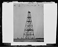 Cobb's Hill, Lookout Tower, Dutch Gap, Va - NARA - 529197 (page 2).jpg 3,000 × 2,392; 679 KB
-
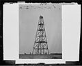 Cobb's Hill, Lookout Tower, Dutch Gap, Va - NARA - 529197.jpg 3,000 × 2,392; 1.06 MB
-
 DiggingDutchGapCanalNov1864.jpg 800 × 745; 384 KB
-
 Dutch Gap Canal (...) April 1865 LCCN98503436.jpg 3,272 × 4,096; 2.15 MB
-
 Dutch Gap Canal (...) April 1865 LCCN98503444.jpg 3,283 × 4,096; 2.88 MB
-
 Dutch Gap Canal and Group of Soldiers. (19352415924).jpg 1,000 × 481; 442 KB
-
 Dutch Gap Canal in 1865 (4166305481).jpg 3,000 × 2,325; 1.99 MB
-
 Dutch Gap Canal in 1865 (4167054640).jpg 3,000 × 2,303; 1.97 MB
-
 Dutch Gap Canal in 1865 - NARA - 524845 (page 1).gif 600 × 465; 102 KB
-
 Dutch Gap Canal in 1865 - NARA - 524845.jpg 3,000 × 2,325; 2.02 MB
-
 Dutch Gap Canal in 1865 - NARA - 524846 (page 1).gif 600 × 461; 98 KB
-
 Dutch Gap Canal in 1865 - NARA - 524846.jpg 3,000 × 2,303; 2.03 MB
-
 Dutch Gap Canal LCCN2012649998.jpg 3,505 × 2,976; 1.17 MB
-
 Dutch Gap Canal LCCN2012649999.jpg 3,306 × 3,019; 1.61 MB
-
 Dutch Gap Canal LCCN98503559.jpg 4,096 × 3,261; 2.09 MB
-
 Dutch Gap Canal Map.jpg 1,880 × 1,760; 1.97 MB
-
 Dutch Gap Canal MET DP70536.jpg 2,814 × 2,064; 1.73 MB
-
 Dutch Gap Canal MET DP70538.jpg 2,712 × 1,983; 1.75 MB
-
 Dutch Gap Canal MET DP70570.jpg 2,415 × 1,560; 1.06 MB
-
 Dutch Gap Canal MET DP70571.jpg 2,499 × 1,905; 1.75 MB
-
 Dutch Gap Canal, James River - NARA - 524424 (page 1).gif 600 × 472; 80 KB
-
 Dutch Gap Canal, James River - NARA - 524424.jpg 3,000 × 2,358; 1.29 MB
-
 Dutch Gap Canal, James River MET DP70595.jpg 2,400 × 1,786; 1.12 MB
-
 Dutch Gap Canal, James River, Va - NARA - 525081 (page 1).gif 600 × 444; 118 KB
-
 Dutch Gap Canal, James River, Va - NARA - 525081.jpg 3,000 × 2,221; 2.28 MB
-
 Dutch Gap Canal, James River, Va - NARA - 526202 (page 1).gif 600 × 482; 114 KB
-
 Dutch Gap Canal, James River, Va - NARA - 526202.jpg 3,000 × 2,409; 2.11 MB
-
 Dutch Gap Canal, James River, Va - NARA - 527448 (page 1).gif 600 × 320; 65 KB
-
 Dutch Gap Canal, James River, Va - NARA - 527448.jpg 3,000 × 1,598; 1.06 MB
-
 Dutch Gap Canal, James River, Va - NARA - 528210 (page 1).gif 600 × 319; 63 KB
-
 Dutch Gap Canal, James River, Va - NARA - 528210 (page 2).jpg 3,000 × 1,594; 878 KB
-
 Dutch Gap Canal, James River, Va - NARA - 528210.jpg 3,000 × 1,594; 1.16 MB
-
 Dutch Gap Canal, James River. (3996027090).jpg 3,000 × 2,358; 1.21 MB
-
 Dutch Gap Canal. (3110841070).jpg 760 × 647; 146 KB
-
 Dutch Gap Canal. Blown out Feb. 1865 - NARA - 530423 (page 1).gif 600 × 475; 80 KB
-
 Dutch Gap Canal. Blown out Feb. 1865 - NARA - 530423 (page 2).jpg 3,000 × 2,377; 823 KB
-
 Dutch Gap Canal. Blown out Feb. 1865 - NARA - 530423.jpg 3,000 × 2,377; 1.19 MB
-
 Dutch Gap, James River, Va - NARA - 525209 (page 1).gif 600 × 347; 79 KB
-
 Dutch Gap, James River, Va - NARA - 525209.jpg 3,000 × 1,736; 1.24 MB
-
 Dutch Gap, James River, Virginia (4171676171).jpg 3,000 × 1,736; 1.21 MB
-

-

-

-

-
 Dutch Gap, Virginia. View of Dutch Gap canal LOC cwpb.01922.jpg 7,492 × 7,500; 7.47 MB
-
 DutchGap.jpg 3,000 × 2,698; 3.51 MB
-
 Farrar's Island, Dutch Gap & Landing.jpg 1,700 × 2,200; 321 KB
-
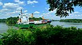 Feeder ship Reykafoss on the Dutch Gap Canal.jpg 1,024 × 576; 122 KB
-
 FinishedDutchGapCanalApril1865.jpg 800 × 716; 304 KB
-
 Gen Butlers Canal at Dutch Gap LCCN2004661269.jpg 8,938 × 3,232; 3.43 MB
-

-
 Iron Wall Dutch Gap Conservation Area Chester VA 8726 (24015362725).jpg 4,320 × 3,240; 3.55 MB
-
 Iron Wall Dutch Gap Conservation Area Chester VA 8730 (23388571673).jpg 3,240 × 4,320; 2.04 MB
-
 Iron Wall Dutch Gap Conservation Area Chester VA 8731 (23387151394).jpg 3,240 × 4,320; 1.64 MB
-
 Iron Wall Dutch Gap Conservation Area Chester VA 8733 (23932813421).jpg 3,240 × 4,320; 2.07 MB
-
 Iron Wall Dutch Gap Conservation Area Chester VA 8734 (24015365435).jpg 2,589 × 4,304; 1.26 MB
-
 Iron Wall Dutch Gap Conservation Area Chester VA 8736 (23932814521).jpg 1,729 × 2,871; 1.08 MB
-
 Iron Wall Dutch Gap Conservation Area Chester VA 8738 (23989273206).jpg 3,240 × 4,320; 3.04 MB
-
 Iron Wall Dutch Gap Conservation Area Chester VA 8739 (23932816781).jpg 3,240 × 4,320; 2.77 MB
-
 Iron Wall Dutch Gap Conservation Area Chester VA 8740 (23647503189).jpg 3,240 × 4,320; 3 MB
-
 Iron Wall Dutch Gap Conservation Area Chester VA 8741 (23388578873).jpg 3,240 × 4,320; 3.07 MB
-
 James River from Crow's Nest, Dutch Gap Canal in distance - NARA - 524834.jpg 3,000 × 2,389; 2.89 MB
-
 JamesRiverAboveDutchGap.jpg 1,100 × 1,213; 542 KB
-
 LC-DIG-PPMSCA-22503 (20297422718).jpg 8,885 × 5,926; 50.05 MB
-
 Osprey Nest Dutch Gap Conservation Area Chester VA 8716 (23989256326).jpg 4,320 × 3,240; 2.08 MB
-
 Osprey Nest Dutch Gap Conservation Area Chester VA 8718 (23989257046).jpg 2,087 × 2,756; 1.83 MB
-
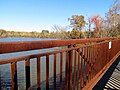
 Pedestrian Bridge Dutch Gap Conservation Area Chester VA 8749 (23989288376).jpg 4,320 × 3,240; 3.03 MB
-
 Pedestrian Bridge Dutch Gap Conservation Area Chester VA 8750 (23388591983).jpg 4,320 × 3,240; 2.62 MB
-
 Pedestrian Bridge Dutch Gap Conservation Area Chester VA 8751 (23907153402).jpg 4,320 × 3,240; 2.65 MB
-
 Pedestrian Bridge Dutch Gap Conservation Area Chester VA 8752 (23387172624).jpg 4,320 × 3,240; 2.65 MB
-
 Pedestrian Bridge Dutch Gap Conservation Area Chester VA 8753 (23989292366).jpg 4,320 × 3,240; 1.94 MB
-
 Pedestrian Bridge Dutch Gap Conservation Area Chester VA 8754 (24015388475).jpg 3,240 × 4,320; 3.55 MB
-
 Pedestrian Bridge Dutch Gap Conservation Area Chester VA 8757 (23647524479).jpg 3,240 × 4,320; 4.32 MB
-
 Possibly by andrew joseph russell dutch gap canal james river virginia102653).jpg 3,200 × 2,464; 1.43 MB
-
 Possibly by andrew joseph russell dutch gap canal james river virginia102753).jpg 3,200 × 2,446; 1.66 MB
-
 Power Station Dutch Gap Conservation Area Chester VA 8711 (24015344005).jpg 4,320 × 3,240; 4.45 MB
-

-
 Reflection Dutch Gap Conservation Area Chester VA 8640 (24015248725).jpg 4,320 × 3,240; 3.76 MB
-
 Reflection Dutch Gap Conservation Area Chester VA 8667 (24015287785).jpg 3,240 × 4,320; 3.71 MB
-
 Reflection Dutch Gap Conservation Area Chester VA 8668 (23647421609).jpg 3,240 × 4,320; 3.73 MB
-
 Reflection Dutch Gap Conservation Area Chester VA 8669 (23932738441).jpg 4,320 × 3,240; 4.04 MB
-
 Reflection Dutch Gap Conservation Area Chester VA 8670 (23719599850).jpg 4,320 × 3,240; 5.21 MB
-
 Reflection Dutch Gap Conservation Area Chester VA 8672 (23907061722).jpg 4,320 × 3,240; 3.89 MB
-
 Reflection Dutch Gap Conservation Area Chester VA 8688 (23647444879).jpg 4,320 × 3,240; 3.7 MB
-
 Reflection Dutch Gap Conservation Area Chester VA 8689 (23647446519).jpg 4,320 × 3,240; 3.92 MB
-
 Reflection Dutch Gap Conservation Area Chester VA 8690 (23932762701).jpg 4,320 × 3,240; 3.9 MB
-
 Reflection Dutch Gap Conservation Area Chester VA 8692 (23647450909).jpg 4,320 × 3,240; 4.69 MB
-
 Reflection Dutch Gap Conservation Area Chester VA 8693 (23907087502).jpg 4,320 × 3,240; 4.76 MB
-
 Reflection Dutch Gap Conservation Area Chester VA 8695 (23989228546).jpg 4,320 × 3,240; 4.46 MB
-
 Reflection Dutch Gap Conservation Area Chester VA 8698 (23388533743).jpg 4,320 × 3,240; 3.56 MB
-
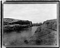
 River view, Dutch Gap Canal in distance - NARA - 529402.jpg 3,000 × 2,309; 2.16 MB
-
 Stick Dutch Gap Conservation Area Chester VA 8678 (23647432669).jpg 4,320 × 3,240; 2.93 MB
-

-

-

-
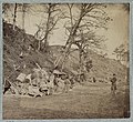
 USCT Working on Dutch Gap.jpg 4,170 × 2,537; 7.01 MB
-
 View of Dutch Gap, James River, Va - NARA - 524780.jpg 3,000 × 2,524; 1.84 MB
-
 View of James River from Dutch Gap, Va - NARA - 529490.jpg 3,000 × 1,345; 1.23 MB
-
 View of James River looking down from Dutch Gap - NARA - 529336.jpg 2,964 × 2,359; 1.34 MB
-
 View of James River, from Dutch Gap - NARA - 529155.jpg 3,000 × 2,347; 1.51 MB
-
 View of James River, looking down from Dutch Gap Canal - NARA - 529300.jpg 3,000 × 2,324; 1.79 MB
-
 View on James River near Dutch Gap - NARA - 529476.jpg 3,000 × 1,347; 866 KB
-
 Virginia, Dutch Gap Canal on the James River, eight miles from Richmond. - NARA - 533360.jpg 3,000 × 2,497; 1.97 MB
-

-

-

-

-
 Dutch Gap Canal, from Robert N. Dennis collection of stereoscopic views.jpg 2,737 × 1,365; 1.36 MB
-
 Dutch Gap Canal, from Robert N. Dennis collection of stereoscopic views.png 2,737 × 1,365; 4.5 MB
-
 Dutch Gap Canal, James River, by George O. Ennis.jpg 2,737 × 1,370; 1.51 MB
-

-

-

-

-

-
 View of Butler's Dutch Gap Canal, by William Frank Browne.jpg 2,737 × 1,340; 1.3 MB
-
 View of Butler's Dutch Gap Canal, by William Frank Browne.png 2,737 × 1,340; 4.44 MB
-


.jpg)


_(14769590362).jpg)
.jpg)
.jpg)


.jpg)
.jpg)
.jpg)
.jpg)
.jpg)
.jpg)
.jpg)
.jpg)
.jpg)
.gif)
.jpg)


_April_1865_LCCN98503436.jpg)
_April_1865_LCCN98503444.jpg)
.jpg)
.jpg)
.jpg)
.gif)

.gif)


.gif)


.gif)

.gif)

.gif)

.gif)
.jpg)

.jpg)
.jpg)
.gif)
.jpg)

.gif)

.jpg)
._Deserted_farm_house_near_Dutch_Gap_canal_LOC_6056603687.jpg)
._Deserted_farm_house_near_Dutch_Gap_canal_LOC_6057152108.jpg)
._Pontoon_boats_on_wheeled_carriages_at_deserted_farm_house_near_Dutch_Gap_canal_LOC_cwpb.01937.jpg)


.jpg)
.jpg)
.jpg)
.jpg)
.jpg)
.jpg)
.jpg)
.jpg)
.jpg)
.jpg)


.jpg)
.jpg)
.jpg)
.jpg)
.jpg)
.jpg)
.jpg)
.jpg)
.jpg)
.jpg)
.jpg)
.jpg)
.jpg)

.jpg)
.jpg)
.jpg)
.jpg)
.jpg)
.jpg)
.jpg)
.jpg)
.jpg)
.jpg)
.jpg)
.jpg)
.jpg)

.jpg)
_(14759774021).jpg)
_(14760493754).jpg)
_(14762685795).jpg)


_is_a_dam_to_keep_out_the_water...,_from_Robert_N._Dennis_collection_of_stereoscopic_views.jpg)


