Category:Earth Observing System program
program of NASA comprising a series of artificial satellite missions and scientific instruments in Earth orbit    | |||||
| Upload media | |||||
| Instance of | |||||
|---|---|---|---|---|---|
| Part of |
| ||||
| |||||
Subcategories
This category has the following 3 subcategories, out of 3 total.
Media in category "Earth Observing System program"
The following 7 files are in this category, out of 7 total.
-
 Arctic melt trends graph.png 720 × 578; 176 KB
-
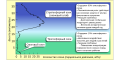 Atmospheric Ozone Rus.svg 1,280 × 640; 53 KB
-
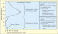 Atmospheric-Ozone.png 1,163 × 688; 30 KB
-
 EOS Data Collection.png 1,480 × 978; 207 KB
-
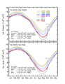 NASA NH decadal ice extent 2022.png 720 × 932; 284 KB
-
 NASA NH yearly ice extent 2022.png 720 × 932; 284 KB
-
 Spseaice sss 2012170 chart.jpg 720 × 183; 17 KB


