Category:Eaton and Eccleston
English: Eaton and Eccleston is a civil parish in the Cheshire West and Chester district, in the county of Cheshire, England.
civil parish in Cheshire West and Chester, Cheshire, England | |||||
| Upload media | |||||
| Instance of | |||||
|---|---|---|---|---|---|
| Location | Cheshire West and Chester, Cheshire, North West England, England | ||||
| Replaces | |||||
 | |||||
Subcategories
This category has the following 8 subcategories, out of 8 total.
B
C
- Claverton, Cheshire (6 F)
E
G
- Golden Gates, Eaton Hall (3 F)
M
- Marlston-cum-Lache (2 F)
S
- St Mary's School, Eccleston (1 F)
Media in category "Eaton and Eccleston"
The following 199 files are in this category, out of 199 total.
-
 A tree giving a splash of colour on the bank of the cutting - geograph.org.uk - 4488581.jpg 1,600 × 1,200; 1.29 MB
-
 A483 - geograph.org.uk - 5498162.jpg 1,024 × 576; 214 KB
-
 A483 - the final straight - geograph.org.uk - 2251294.jpg 640 × 480; 43 KB
-
 A483 approaching B5445 roundabout - geograph.org.uk - 2409153.jpg 640 × 480; 79 KB
-

-
 A483 at Belgrave Bridge - geograph.org.uk - 5504292.jpg 640 × 427; 304 KB
-
 A483 South of Chester - geograph.org.uk - 5504295.jpg 640 × 480; 374 KB
-

-
 A55 Near Eccleston - geograph.org.uk - 2158985.jpg 640 × 480; 164 KB
-
 A55 sliproad to the A483 - geograph.org.uk - 3950126.jpg 640 × 479; 46 KB
-
 A55 westbound crossing the River Dee - geograph.org.uk - 2360684.jpg 640 × 481; 35 KB
-
 A55, Eaton Road Bridge - geograph.org.uk - 2158994.jpg 640 × 480; 140 KB
-
 A55, South of Chester - geograph.org.uk - 2158999.jpg 640 × 480; 148 KB
-
 Aldford Iron Bridge - geograph.org.uk - 2400833.jpg 3,888 × 2,592; 5.53 MB
-
 Alvis Saracen at Eaton Hall - geograph.org.uk - 5548147.jpg 3,184 × 2,123; 2.26 MB
-
 Approaching the A483 - geograph.org.uk - 3337205.jpg 5,184 × 3,456; 4.53 MB
-
 Approaching the Monument - geograph.org.uk - 4095364.jpg 3,306 × 2,496; 1.51 MB
-
-
 Aérospatiale Gazelle at Eaton Hall - geograph.org.uk - 4985362.jpg 5,184 × 3,456; 5.28 MB
-
 B5445 at Belgrave - geograph.org.uk - 5877676.jpg 6,000 × 4,000; 5.44 MB
-
 Bandstand in Eaton Gardens - geograph.org.uk - 3483038.jpg 4,072 × 2,672; 2.44 MB
-
 Beehives at Eaton Hall - geograph.org.uk - 4095213.jpg 4,000 × 2,248; 4 MB
-
 Belgrave Avenue heading East - geograph.org.uk - 4135885.jpg 3,456 × 2,520; 2.28 MB
-
 Belgrave Avenue heading West - geograph.org.uk - 4135902.jpg 4,000 × 3,000; 3.41 MB
-
 Belgrave Sunset - geograph.org.uk - 5640175.jpg 3,643 × 2,438; 1.64 MB
-
 Bench mark at Eccleston Ferry - geograph.org.uk - 3822721.jpg 480 × 640; 217 KB
-
 Bench mark in Paddock Road, Eccleston - geograph.org.uk - 4799036.jpg 4,113 × 3,082; 2.89 MB
-
 Bridge on the Lake at Eaton Hall - geograph.org.uk - 3482879.jpg 3,762 × 2,580; 2.63 MB
-
 Buildings on the Eaton Hall Estate - geograph.org.uk - 2400673.jpg 3,888 × 2,592; 2.69 MB
-
 Bus stops on Wrexham Road (B5445) - geograph.org.uk - 6163254.jpg 800 × 600; 123 KB
-
 Cadillac at Eaton Hall - geograph.org.uk - 4095290.jpg 4,000 × 3,000; 4.13 MB
-
 Cattle near Belgrave - geograph.org.uk - 5877846.jpg 5,489 × 3,660; 5.86 MB
-
 Chester Approach and a new boundary stone - geograph.org.uk - 5995109.jpg 1,200 × 1,600; 807 KB
-
 Chester Approach near Handbridge - geograph.org.uk - 4115455.jpg 4,000 × 3,000; 4.12 MB
-
 Chester Approach Woodland - geograph.org.uk - 4115580.jpg 3,000 × 4,000; 4.44 MB
-
 Chester bypass - Eaton Road bridge - geograph.org.uk - 2875087.jpg 639 × 450; 112 KB
-
 Chester bypass on the River Dee bridge - geograph.org.uk - 2875090.jpg 639 × 453; 103 KB
-
 Chester Racecourse, aerial 2015 - geograph.org.uk - 4695536.jpg 1,024 × 683; 224 KB
-
 Church Road from the shelter - geograph.org.uk - 3826784.jpg 480 × 640; 128 KB
-
 Church Road, Eccleston - geograph.org.uk - 4799229.jpg 4,000 × 3,000; 3.35 MB
-
 Clock Tower and Fountain - geograph.org.uk - 6298508.jpg 4,000 × 6,000; 4.02 MB
-
 Course of Roman Road at Eaton Hall - geograph.org.uk - 4983748.jpg 5,184 × 3,456; 6.16 MB
-
 Course of Roman Road at Eaton Hall - geograph.org.uk - 4983771.jpg 5,184 × 3,456; 5.46 MB
-
 Course of Roman Road at Eaton Hall - geograph.org.uk - 4985328.jpg 5,184 × 3,456; 6.3 MB
-
 Cows at The Crook of Dee - geograph.org.uk - 1842949.jpg 1,024 × 768; 313 KB
-
 Cows cooling off at Eccleston - geograph.org.uk - 5489565.jpg 1,024 × 768; 280 KB
-
 Daffodils on the Eaton Estate - geograph.org.uk - 2400748.jpg 3,888 × 2,592; 3.37 MB
-
 Display Area of Eaton Hall Gardens Open Day - geograph.org.uk - 3482993.jpg 5,088 × 3,348; 3.89 MB
-
 Display of Military Vehicles at Eaton Hall - geograph.org.uk - 4983982.jpg 5,184 × 3,456; 6.06 MB
-
 Duck herding at Eaton Hall - geograph.org.uk - 6298501.jpg 6,000 × 4,000; 3.87 MB
-
 Eastbound slip road onto Chester bypass - geograph.org.uk - 4488568.jpg 1,600 × 1,067; 1.07 MB
-
 Eaton Chapel and Hall - geograph.org.uk - 3620676.jpg 6,848 × 4,695; 4.09 MB
-
 Eaton Gardens Charity Open Day - geograph.org.uk - 3483010.jpg 4,088 × 2,648; 2.77 MB
-
 Eaton Hall and Chapel - geograph.org.uk - 3620611.jpg 7,632 × 4,291; 2.93 MB
-
 Eaton Hall Chapel Bell Tower - geograph.org.uk - 6298523.jpg 4,000 × 6,000; 4.03 MB
-
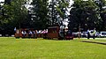
 Eaton Hall charity open day (29th May 2016) - geograph.org.uk - 4985308.jpg 5,184 × 3,456; 5.93 MB
-
 Eaton Hall charity open day (29th May 2016) - geograph.org.uk - 4985343.jpg 5,184 × 3,456; 5.2 MB
-
 Eaton Hall from the Dragon Garden - geograph.org.uk - 4983929.jpg 4,928 × 3,416; 3.34 MB
-
 Eaton Hall from the Lake - geograph.org.uk - 4095232.jpg 4,000 × 2,248; 2.74 MB
-
 Eaton Hall Garden - geograph.org.uk - 5548105.jpg 3,184 × 2,123; 3.15 MB
-
 Eaton Hall Garden - geograph.org.uk - 6207768.jpg 3,305 × 2,732; 4.28 MB
-
 Eaton Hall Gardens - geograph.org.uk - 3483048.jpg 5,072 × 3,355; 4.04 MB
-
 Eaton Hall Gardens - geograph.org.uk - 3483062.jpg 4,558 × 2,952; 3.05 MB
-
 Eaton Hall Gardens Charity Open Day (27th July 2014) - geograph.org.uk - 4093462.jpg 4,000 × 3,000; 3.03 MB
-
 Eaton Hall Gardens near Chester - Clock Tower - geograph.org.uk - 5231151.jpg 5,184 × 2,920; 1.26 MB
-
 Eaton Hall Gardens near Chester - Courtyard - geograph.org.uk - 5231137.jpg 5,184 × 2,920; 4.76 MB
-
 Eaton Hall Gardens near Chester - lake ^ rhododendron banks - geograph.org.uk - 5231146.jpg 5,184 × 2,920; 6.44 MB
-
 Eaton Hall Gardens near Chester - Lake ^ rhododendrons - geograph.org.uk - 5231140.jpg 5,184 × 2,920; 5.39 MB
-

-
 Eaton Hall Gardens near Chester - Lioness ^ Kudu Pond - geograph.org.uk - 5231155.jpg 5,184 × 2,920; 5.21 MB
-
 Eaton Hall Gardens near Chester - Rhododendrons by lake - geograph.org.uk - 5231142.jpg 5,184 × 2,920; 6.34 MB
-

-

-
 Eaton Hall Gardens near Chester -Tea House Garden - geograph.org.uk - 5231148.jpg 5,184 × 2,920; 6.36 MB
-
 Eaton Hall Grotto - geograph.org.uk - 3945574.jpg 480 × 640; 81 KB
-
 Eaton Hall Kitchen Garden - geograph.org.uk - 3482817.jpg 4,088 × 2,669; 3.28 MB
-
 Eaton Hall Kitchen Garden Orchard - geograph.org.uk - 3482853.jpg 5,040 × 3,316; 3.73 MB
-
 Eaton Hall Railway August 2014 - geograph.org.uk - 6355589.jpg 1,280 × 720; 186 KB
-
 Eaton Road between Chester and Eccleston - geograph.org.uk - 3336961.jpg 5,184 × 3,456; 5.32 MB
-
 Eaton Road bridge over Chester bypass - geograph.org.uk - 4488585.jpg 1,600 × 1,200; 1.37 MB
-
 Eaton Road near Eccleston - geograph.org.uk - 3336954.jpg 5,184 × 3,456; 5.46 MB
-
 Eaton Stud at Eaton Hall - geograph.org.uk - 2400681.jpg 3,888 × 2,592; 7.2 MB
-
 Eccleston, St Mary the Virgin - geograph.org.uk - 6358181.jpg 4,608 × 3,456; 5.47 MB
-
 Entrance to Belgrave Moat Farm - geograph.org.uk - 3337274.jpg 5,184 × 3,456; 2.99 MB
-
 Entrance to Grosvenor Garden Centre - geograph.org.uk - 4083979.jpg 640 × 480; 82 KB
-
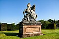
 Equestrian Statue at Eaton Hall - geograph.org.uk - 6207764.jpg 4,128 × 3,096; 4.6 MB
-
 Equestrian Statue in Eaton Hall Gardens - geograph.org.uk - 6298517.jpg 6,000 × 4,000; 4.49 MB
-

-
 Falconry Display at Eaton Hall - geograph.org.uk - 5134623.jpg 4,184 × 2,789; 3.02 MB
-
 Falconry Display at Eaton Hall - geograph.org.uk - 6207789.jpg 2,258 × 1,694; 2.04 MB
-
 Farmland off Wrexham Road (A483) - geograph.org.uk - 6163234.jpg 800 × 529; 94 KB
-
 Field on the Crook of Dee - geograph.org.uk - 2400702.jpg 3,888 × 2,592; 2.52 MB
-
 Field on the Crook of Dee - geograph.org.uk - 2400709.jpg 3,888 × 2,592; 3.07 MB
-
 Flooded car park at Eccleston Ferry - geograph.org.uk - 4777306.jpg 4,608 × 3,456; 3.42 MB
-
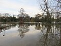
 Flooded meadows at Eccleston Ferry - geograph.org.uk - 4777315.jpg 4,608 × 3,456; 2.55 MB
-
 Footpath beside River Dee near Eccleston - geograph.org.uk - 2115819.jpg 640 × 480; 159 KB
-
 Footpath beside the River Dee - geograph.org.uk - 2115830.jpg 640 × 480; 157 KB
-

-
 Footpath near the River Dee, Cheshire - geograph.org.uk - 2400737.jpg 3,888 × 2,592; 6.42 MB
-
 Footpath off Rake Lane - geograph.org.uk - 3337154.jpg 5,184 × 3,456; 4.53 MB
-
 Footpath off the Wrexham Road - geograph.org.uk - 3337225.jpg 5,184 × 3,456; 4.83 MB
-
 Grazing, Belgrave - geograph.org.uk - 6163253.jpg 800 × 600; 103 KB
-
 Grosvenor Garden Centre - geograph.org.uk - 5877673.jpg 5,687 × 3,788; 4.62 MB
-
 Gun Dog Display at Eaton Hall - geograph.org.uk - 3483160.jpg 5,671 × 3,981; 3.72 MB
-
 Heron's Way, Chester Business Park - geograph.org.uk - 2157520.jpg 799 × 480; 209 KB
-

-
 Hill Road from the shelter - geograph.org.uk - 3826786.jpg 480 × 640; 128 KB
-
 Hill Road, Eccleston - geograph.org.uk - 3337043.jpg 5,184 × 3,456; 3.89 MB
-
 Holiday Inn Chester - geograph.org.uk - 1393441.jpg 640 × 388; 74 KB
-
 Houses on Wrexham Road (B5445) - geograph.org.uk - 6163247.jpg 800 × 542; 139 KB
-
 In the grounds of Eaton Hall - geograph.org.uk - 6298273.jpg 6,000 × 4,000; 4.14 MB
-

-
 Junction of the A483 and the Straight Mile - geograph.org.uk - 3337255.jpg 5,184 × 3,456; 2.45 MB
-
 Junction of the B5445 and Rake Lane - geograph.org.uk - 3337192.jpg 5,184 × 3,456; 4.91 MB
-
 Katie at Eaton Hall - geograph.org.uk - 6355580.jpg 3,648 × 2,048; 3.3 MB
-
 Kitchen Garden Gateway at Eaton Hall - geograph.org.uk - 3482860.jpg 5,072 × 3,355; 3.44 MB
-
 Lakeside path at Eaton Hall - geograph.org.uk - 4095256.jpg 4,000 × 2,248; 3.47 MB
-
 Layby on A483 - geograph.org.uk - 4605802.jpg 1,024 × 768; 105 KB
-
 Lioness and Kudu Pond at Eaton Hall - geograph.org.uk - 3483084.jpg 5,034 × 2,934; 3.21 MB
-
 Lodgehouse at the side of The Dee - geograph.org.uk - 1842953.jpg 1,024 × 768; 316 KB
-
 Low Bridge. - geograph.org.uk - 512413.jpg 427 × 640; 83 KB
-
 Machinery Display at Eaton Hall Gardens - geograph.org.uk - 3483072.jpg 5,072 × 3,302; 2.93 MB
-
 Marker Stone at Eaton Hall - geograph.org.uk - 4983862.jpg 5,184 × 3,456; 6.16 MB
-
 Mud and grass country, Belgrave - geograph.org.uk - 5540392.jpg 1,024 × 684; 400 KB
-
 Offices in Chester Business Park - geograph.org.uk - 3444805.jpg 1,600 × 1,200; 385 KB
-
 Ordnance Survey Cut Mark - geograph.org.uk - 4992706.jpg 597 × 640; 144 KB
-
 Paddock Road from the shelter - geograph.org.uk - 3826782.jpg 480 × 640; 121 KB
-
 Paddock Road, Eccleston - geograph.org.uk - 4799041.jpg 4,608 × 3,456; 5.37 MB
-
 Parkland near Eaton Hall - geograph.org.uk - 5877858.jpg 6,000 × 4,000; 6.71 MB
-

-
 Path beside R Dee S of Eccleston near Chester - geograph.org.uk - 5246244.jpg 5,184 × 2,920; 6.63 MB
-
 Path from the Chester Approach - geograph.org.uk - 4115572.jpg 4,000 × 3,000; 4.12 MB
-
 Pivot bench mark in Church Road, Eccleston - geograph.org.uk - 4799220.jpg 3,000 × 4,000; 3.62 MB
-
 Rake Lane and Chester Approach bridge - geograph.org.uk - 4822021.jpg 4,608 × 3,456; 5.57 MB
-
 Rake Lane approaching Eccleston - geograph.org.uk - 3337067.jpg 5,184 × 3,456; 4.64 MB
-

-
 Rake Lane Cottages on Rake Lane - geograph.org.uk - 3337128.jpg 5,184 × 3,456; 4.28 MB
-
 Rake Lane heading towards Wrexham Road - geograph.org.uk - 3337075.jpg 5,184 × 3,456; 3.79 MB
-
 Rake Lane, Eccleston - geograph.org.uk - 3337052.jpg 5,184 × 3,456; 5.2 MB
-
 Renovation work at Eaton Hall - geograph.org.uk - 6207772.jpg 4,128 × 3,096; 3.93 MB
-

-
 River Dee - Eccleston - geograph.org.uk - 2396615.jpg 792 × 926; 514 KB
-
 River Dee at Saltney, aerial 2015 - geograph.org.uk - 4695528.jpg 1,600 × 967; 303 KB
-
 River Dee from A55 - geograph.org.uk - 2409170.jpg 640 × 480; 71 KB
-
 River Dee from A55 westbound - geograph.org.uk - 2422947.jpg 640 × 480; 60 KB
-
 River Dee riverside walk near Eaton Hall - geograph.org.uk - 2400691.jpg 3,888 × 2,592; 7.7 MB
-
 Riverside walk near Eaton Lodge - geograph.org.uk - 5491331.jpg 3,184 × 2,123; 3.09 MB
-
 Riverside Walk near Eccleston - geograph.org.uk - 2400632.jpg 3,888 × 2,592; 7.28 MB
-
 Riverside Walk near Eccleston - geograph.org.uk - 2400640.jpg 3,888 × 2,592; 3.38 MB
-
 Riverside Walk near Eccleston - geograph.org.uk - 2400662.jpg 3,888 × 2,592; 3.03 MB
-
 Riverside Walk near Eccleston - geograph.org.uk - 2400664.jpg 3,888 × 2,592; 2.75 MB
-
 Riverside walk on the River Dee - geograph.org.uk - 2400814.jpg 3,885 × 2,590; 3.66 MB
-
 Rolls-Royce Light Armoured Car at Eaton Hall - geograph.org.uk - 3483100.jpg 5,088 × 3,322; 3.7 MB
-
 Roman Column in Eaton Hall Gardens - geograph.org.uk - 6298496.jpg 4,000 × 6,000; 4.34 MB
-
 Rush hour traffic on the A55 - geograph.org.uk - 6302409.jpg 640 × 426; 72 KB
-

-

-
 Sliproad leaving the A55 - geograph.org.uk - 3480077.jpg 3,872 × 2,592; 2.75 MB
-
 Small tortoiseshell in Eaton Hall Gardens - geograph.org.uk - 6297477.jpg 6,000 × 4,000; 5.43 MB
-
 Stag on the staging - geograph.org.uk - 5800830.jpg 640 × 480; 93 KB
-
 Tea House and Garden at Eaton Hall - geograph.org.uk - 3482898.jpg 5,004 × 3,318; 3.81 MB
-
 The A55 crosses the River Dee near Eccleston - geograph.org.uk - 5489635.jpg 1,024 × 768; 172 KB
-
 The A55 near Eccleston - geograph.org.uk - 3336936.jpg 5,184 × 3,456; 3.77 MB
-
 The B5445 near Belgrave - geograph.org.uk - 5877852.jpg 6,000 × 4,000; 6.01 MB
-

-
 The Chester Approach drive near Eccleston - geograph.org.uk - 5489649.jpg 1,024 × 768; 306 KB
-
 The Lady Diana on the Dee - geograph.org.uk - 4846643.jpg 640 × 480; 129 KB
-
 The Lake at Eaton Hall - geograph.org.uk - 4095242.jpg 4,000 × 2,248; 3.27 MB
-
 The lake at Eaton Hall - geograph.org.uk - 5548100.jpg 4,184 × 2,789; 2.87 MB
-
 The Loggia in Eaton Hall Gardens - geograph.org.uk - 6298275.jpg 6,000 × 4,000; 4.15 MB
-
 The River Dee - geograph.org.uk - 2089605.jpg 1,200 × 803; 299 KB
-
 The River Dee - geograph.org.uk - 2089610.jpg 1,200 × 803; 257 KB
-
 The River Dee - geograph.org.uk - 2089617.jpg 1,200 × 803; 270 KB
-
 The River Dee at Eccleston - geograph.org.uk - 3809081.jpg 4,000 × 3,000; 2.75 MB
-
 The River Dee at Eccleston - geograph.org.uk - 3809091.jpg 4,000 × 3,000; 4.45 MB
-
 The River Dee at Eccleston - geograph.org.uk - 3809104.jpg 4,000 × 3,000; 3.32 MB
-
 The River Dee at Eccleston - geograph.org.uk - 3809109.jpg 4,000 × 3,000; 3.32 MB
-
 The River Dee from Eaton Hall Gardens - geograph.org.uk - 4093558.jpg 4,000 × 2,248; 2.5 MB
-
 The River Dee near Eaton Hall - geograph.org.uk - 2400718.jpg 3,888 × 2,592; 2.6 MB
-
 The River Dee near Eaton Hall - geograph.org.uk - 2400820.jpg 3,888 × 2,592; 5.89 MB
-
 The River Dee near Eaton Hall - geograph.org.uk - 5491339.jpg 3,184 × 2,123; 2.44 MB
-
 The River Dee near Eaton Hall - geograph.org.uk - 5491359.jpg 3,184 × 2,123; 2.93 MB
-

-
 The Straight Mile - geograph.org.uk - 3337286.jpg 5,184 × 3,456; 5.45 MB
-
 The Straight Mile heading towards Poulton - geograph.org.uk - 3337292.jpg 5,184 × 3,456; 3.63 MB
-
 The Straight Mile near Poulton - geograph.org.uk - 3337297.jpg 5,184 × 3,456; 4.75 MB
-
 Tree Planting Near Chester Approach - geograph.org.uk - 1043160.jpg 640 × 480; 47 KB
-
 Trees in the Garden of Eaton Hall - geograph.org.uk - 6207781.jpg 4,128 × 3,096; 4.18 MB
-
 View from Chester Approach - geograph.org.uk - 4095350.jpg 3,768 × 2,856; 2.06 MB
-
 View South from Belgrave Avenue - geograph.org.uk - 1043068.jpg 640 × 480; 81 KB
-
 Weathered bench mark in Rake Lane, Eccleston - geograph.org.uk - 4822004.jpg 3,477 × 2,609; 2.76 MB
-
 Welcome to Chester - geograph.org.uk - 3337014.jpg 5,184 × 3,456; 4.71 MB
-
 Wendy House at Eaton Hall - geograph.org.uk - 3482908.jpg 5,072 × 3,329; 3.93 MB
-
 Wild Flower Garden at Eaton Hall - geograph.org.uk - 3482931.jpg 5,040 × 3,342; 4.22 MB
-
 Wildflowers in Eaton Hall Gardens - geograph.org.uk - 6298269.jpg 6,000 × 4,000; 4.57 MB
-
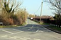
 Wrexham Road (A483) - geograph.org.uk - 6163246.jpg 800 × 600; 99 KB
-

-
 Wrexham Road (B5445) - geograph.org.uk - 6163249.jpg 800 × 600; 148 KB
-
 WWII bomb crater at Heronbridge - geograph.org.uk - 4846647.jpg 640 × 480; 130 KB


_-_geograph.org.uk_-_2251304.jpg)


_-_geograph.org.uk_-_6163254.jpg)


_-_geograph.org.uk_-_4985308.jpg)
_-_geograph.org.uk_-_4985343.jpg)


_-_geograph.org.uk_-_4093462.jpg)


_-_geograph.org.uk_-_6163234.jpg)


_-_geograph.org.uk_-_6163247.jpg)


_-_geograph.org.uk_-_6163240.jpg)


_-_geograph.org.uk_-_6163246.jpg)
_approaching_roundabout_-_geograph.org.uk_-_6163235.jpg)
_-_geograph.org.uk_-_6163249.jpg)
