Category:Ehemalige Marienkapelle / Bauernhaus (Stampachgasse 53, Bolligen)
| Object location | | View all coordinates using: OpenStreetMap |
|---|
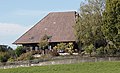
formerly a church building and then a farm building in Bolligen in the canton of Bern, Switzerland  | |||||
| Upload media | |||||
| Instance of | |||||
|---|---|---|---|---|---|
| Part of | |||||
| Location | Habstetten, Bolligen, Bern-Mittelland administrative district, Bernese Mittelland administrative region, Bern, Switzerland | ||||
| Street address |
| ||||
| Heritage designation |
| ||||
| Inception |
| ||||
 | |||||
Media in category "Ehemalige Marienkapelle / Bauernhaus (Stampachgasse 53, Bolligen)"
The following 2 files are in this category, out of 2 total.
-
 Bauernhaus Stampachgasse 53.jpg 1,713 × 1,044; 864 KB
-
 Habstetten Hubel 1.jpg 3,019 × 4,025; 2.4 MB
