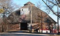
Category:Ehlers Round Barn (Lancaster County, Nebraska)
| Object location | | View all coordinates using: OpenStreetMap |
|---|
former historic structure in Roca, Nebraska, US  | |||||
| Upload media | |||||
| Instance of | |||||
|---|---|---|---|---|---|
| Location | Nebraska | ||||
| Heritage designation | |||||
 | |||||
Media in category "Ehlers Round Barn (Lancaster County, Nebraska)"
The following 2 files are in this category, out of 2 total.
-
 Ehlers round barn from W 1.JPG 2,560 × 1,382; 1.49 MB
-
 Ehlers round barn from W 2.JPG 1,930 × 1,160; 989 KB
