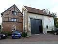
Category:Eindstraat 4, Sint Geertruid
| Object location | | View all coordinates using: OpenStreetMap |
|---|
building in Sint Geertruid, Netherlands  | |||||
| Upload media | |||||
| Instance of | |||||
|---|---|---|---|---|---|
| Location | Sint Geertruid, Margraten, Limburg, Netherlands | ||||
| Street address |
| ||||
| Located on street |
| ||||
| Heritage designation |
| ||||
 | |||||
|
This is a category about rijksmonument number 34690
|
| Address |
|
Media in category "Eindstraat 4, Sint Geertruid"
The following 2 files are in this category, out of 2 total.
-
 Overzicht - Sint Geertruid - 20075589 - RCE.jpg 1,200 × 802; 184 KB
-
 Sint Geertruid-Eindstraat 4.JPG 4,000 × 3,000; 5 MB
