Category:Ermitage Saint-Gerbold
| Object location | | View all coordinates using: OpenStreetMap |
|---|
|
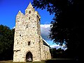
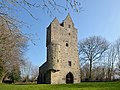
This building is classé au titre des monuments historiques de la France. It is indexed in the base Mérimée, a database of architectural heritage maintained by the French Ministry of Culture, under the reference PA00110668
|
hermitage located in Manche, in France  | |||||
| Upload media | |||||
| Instance of | |||||
|---|---|---|---|---|---|
| Location | Gratot, canton of Saint-Malo-de-la-Lande | ||||
| Architectural style | |||||
| Has use | |||||
| Owned by |
| ||||
| Heritage designation |
| ||||
| Inception |
| ||||
 | |||||
Media in category "Ermitage Saint-Gerbold"
The following 12 files are in this category, out of 12 total.
-
 Ermitage saint gerbold.jpg 1,024 × 1,365; 262 KB
-
 Ermitage Saint-Gerbold de Gratot (2).JPG 4,000 × 3,000; 2.44 MB
-
 Ermitage Saint-Gerbold de Gratot (3).JPG 4,000 × 3,000; 2.54 MB
-
 Ermitage Saint-Gerbold de Gratot (4).JPG 4,000 × 3,000; 2.55 MB
-
 Ermitage Saint-Gerbold de Gratot (5).JPG 3,000 × 4,000; 2.59 MB
-
 Ermitage Saint-Gerbold de Gratot.JPG 2,304 × 1,728; 2.27 MB
-
 GratotErmitage 1.jpg 4,000 × 3,000; 7.13 MB
-
 GratotErmitage 2.jpg 3,736 × 2,802; 6.07 MB
-
 GratotErmitage 3.jpg 2,678 × 6,727; 10.7 MB
-
 Hambye21.JPG 2,304 × 3,072; 1.09 MB
-
 Hambye22.JPG 3,072 × 2,304; 1.17 MB
-
 Saint gerbold.jpg 1,024 × 1,365; 182 KB
.JPG)
.JPG)
.JPG)
.JPG)


