Category:Esplanade Jean-Marie Louvel
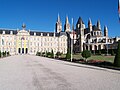
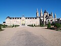
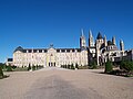
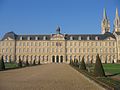
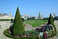
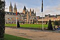
English: in 1727, the land to the east of the Abbaye aux Hommes was raised by 25 feet: a retaining wall was built to the south in order to form a large esplanade on which formal gardens were laid out, comprising flowerbeds, rows of trees and knot gardens. These elements were replaced by lawns and horse-chestnut trees in the 19th century. In 1964, the formal gardens of the Esplanade Jean-Marie Louvel were redesigned by Louis Bouket according to plans dating back to the 18th century.
Français : en 1727, les terrains à l'est de l'abbaye aux Hommes sont remblayés de 25 pieds ; un mur de soutènement est construit au sud afin de former une grande esplanade sur laquelle on aménage des jardins à la Française, formées de parterres, de bosquets et de labyrinthes. Ce jardin est transformé en parc planté de marronniers au XIXe siècle. En 1964, les jardins à la Française de l'esplanade Jean-Marie Louvel ont été redessinés par Louis Bouket d'après des plans du XVIIIe siècle.
| Object location | | View all coordinates using: OpenStreetMap |
|---|
Media in category "Esplanade Jean-Marie Louvel"
The following 53 files are in this category, out of 53 total.
-
 2007-07-28 08-04 Paris, Normandie 0603 Caen, Abbatiale Saint-Etienne.jpg 3,072 × 2,304; 2.89 MB
-
 Abbaye aux Hommes (Caen).jpg 5,930 × 3,943; 1.77 MB
-
 Abbaye aux Hommes 05.jpg 1,012 × 642; 137 KB
-
 Abbaye aux Hommes cadran solaire.JPG 4,272 × 2,848; 3.3 MB
-
 Abbaye Hommes, Caen - 14.jpg 1,136 × 852; 244 KB
-
 Abbaye-aux-hommes.jpg 568 × 426; 46 KB
-

-
 Caen Esplanade Jean-Marie Louvel bâtiment.JPG 4,000 × 2,667; 1.51 MB
-
 Caen esplanade Jean-Marie Louvel plaque commémorative.JPG 4,272 × 2,848; 3.06 MB
-
 Caen esplanade Jean-Marie Louvel plaque souvenir.JPG 2,719 × 2,805; 1.13 MB
-
 Caen esplanade Jean-Marie Louvel Police Municipale.JPG 3,953 × 2,568; 1.39 MB
-
 Caen France (2).JPG 3,264 × 2,448; 5.21 MB
-
 Caen France (3).JPG 3,264 × 2,448; 5.28 MB
-
 Caen France (4).JPG 3,264 × 2,448; 5.58 MB
-
 Caen France (5).JPG 3,264 × 2,448; 5.32 MB
-
 Caen France (6).JPG 3,264 × 2,448; 5.83 MB
-
 Caen France (7).JPG 3,264 × 2,448; 4.95 MB
-
 Caen Hôtel de Ville.JPG 2,272 × 1,704; 2.05 MB
-
 Caen place du parc cpa.jpg 901 × 534; 313 KB
-
 Caen, Lower Normandy, France - panoramio (3).jpg 2,112 × 2,816; 2.46 MB
-
 Drapeau Ukraine Caen.jpg 1,900 × 1,425; 1.28 MB
-
 Eglise de caen 01.JPG 3,216 × 2,136; 3.6 MB
-
 Eglise de caen 02.JPG 3,216 × 2,136; 2.15 MB
-
 Eglise de caen 03.JPG 3,216 × 2,136; 5.54 MB
-
 Eglise de caen 5.JPG 3,143 × 2,087; 1.48 MB
-
 Espla. J-M Louvel, Caen - 14.jpg 1,136 × 852; 189 KB
-
 Mairie Caen cadran solaire est.JPG 4,272 × 2,848; 2.26 MB
-
 Mairie de Caen 01.JPG 3,065 × 2,035; 2.02 MB
-
 Mairie de caen 02 09 2010.jpg 3,211 × 1,575; 757 KB
-
 MAIRIE DE CAEN 055.JPG 3,648 × 2,736; 840 KB
-
 Mairie de Caen 06 09 2010.jpg 1,012 × 642; 358 KB
-
 Mairie de caen 11.JPG 3,216 × 2,136; 2.05 MB
-
 MAIRIE DE CAEN 175.JPG 3,648 × 2,056; 3.55 MB
-
 Mairie de Caen 2.JPG 3,216 × 2,136; 2.36 MB
-
 Mairie de Caen 3.JPG 3,081 × 2,045; 2.13 MB
-
 Mairie de caen 56.JPG 3,216 × 2,136; 2.17 MB
-
 Mairie de Caen 7.JPG 4,272 × 1,912; 811 KB
-
 Mairie de caen 7859.JPG 4,288 × 2,848; 1.7 MB
-
 Mairie de caen 7861.JPG 4,288 × 2,848; 1.73 MB
-
 Mairie de caen 7862.JPG 4,288 × 2,848; 1.61 MB
-
 Mairie de caen 7863.JPG 4,288 × 2,848; 1.55 MB
-
 Mairie de caen 854.JPG 4,288 × 2,848; 1.98 MB
-
 Mairie de Caen 962.JPG 4,912 × 1,080; 4.07 MB
-
 Mairie de Caen St Etienne le 950.JPG 3,848 × 2,848; 3.84 MB
-
 Mairie de Caen St Etienne le Vieux 062.jpg 3,648 × 2,056; 3.68 MB
-
 Mairie de caen St Etienne le Vieux 59.JPG 3,216 × 2,136; 2.02 MB
-
 Mairie de Caen St Etienne le Vieux 835.JPG 3,109 × 2,065; 1.68 MB
-
 Mairie de Caen St Etienne le Vieux Caen Calvados 58.JPG 4,163 × 2,783; 1.13 MB
-
 Marie de caen 02 09 2010-2.JPG 3,216 × 2,136; 2.3 MB
-
 Marie de caen 02 09 2010.JPG 3,216 × 2,136; 4.8 MB
-
 Normandie Calvados Caen6 tango7174.jpg 800 × 600; 247 KB
-
 P1030165 mairie de Caen.JPG 1,600 × 1,200; 430 KB
-
 Église Saint-Étienne-le-Vieux, Caen, Lower Normandy, France - panoramio (1).jpg 2,816 × 2,112; 2.6 MB

.jpg)


.JPG)
.JPG)
.JPG)
.JPG)
.JPG)
.JPG)


.jpg)


.jpg)