Category:Evercreech
English: Evercreech is a village and civil parish north east of Castle Cary, in the Mendip district of Somerset, England. The parish includes the hamlet of Stoney Stratton and the village of Chesterblade.
village and parish in Somerset, England, UK  | |||||
| Upload media | |||||
| Instance of | |||||
|---|---|---|---|---|---|
| Location |
| ||||
| Said to be the same as | Evercreech (Wikimedia duplicated page, civil parish) | ||||
 | |||||
Subcategories
This category has the following 5 subcategories, out of 5 total.
Media in category "Evercreech"
The following 200 files are in this category, out of 243 total.
(previous page) (next page)-
-

-
 2011 , B3081 High Street, Evercreech looking south - geograph.org.uk - 2580087.jpg 3,621 × 2,449; 2.64 MB
-
 2011 , B3081 Prestleigh Road, Evercreech - geograph.org.uk - 2598246.jpg 4,686 × 2,419; 4.26 MB
-
 2011 , Back Lane, Stoney Stratton - geograph.org.uk - 2579798.jpg 4,752 × 3,168; 7.61 MB
-
 2011 , Beefburgers on the hoof, Winterwell Farm - geograph.org.uk - 2548881.jpg 4,214 × 2,680; 4.95 MB
-
 2011 , Brook House, Stoney Stratton - geograph.org.uk - 2596799.jpg 4,752 × 3,168; 7.17 MB
-
 2011 , Coomb, Combe or Bottom near Higher Alham - geograph.org.uk - 2397593.jpg 4,367 × 2,691; 3.85 MB
-
 2011 , Cottages in Queen's Road, Evercreech - geograph.org.uk - 2596848.jpg 3,908 × 2,637; 3.35 MB
-
 2011 , Drive to Fosse Combe Cottage - geograph.org.uk - 2579785.jpg 3,320 × 2,316; 2.45 MB
-
 2011 , East from Chesterblade Road - geograph.org.uk - 2549154.jpg 4,276 × 2,348; 3.38 MB
-
 2011 , East of north from Small Down Lane - geograph.org.uk - 2571279.jpg 4,591 × 2,737; 4.18 MB
-
 2011 , East of south from Maesdown Hill - geograph.org.uk - 2503551.jpg 4,667 × 2,331; 4.5 MB
-
 2011 , Evercreech Co-op and The Green Willow - geograph.org.uk - 2598233.jpg 3,956 × 2,366; 3.07 MB
-
 2011 , Farmland with barn - geograph.org.uk - 2596649.jpg 3,922 × 2,267; 2.75 MB
-

-
 2011 , Hanging baskets in Queen's Road, Evercreech - geograph.org.uk - 2598211.jpg 3,331 × 2,585; 3.24 MB
-
 2011 , Heading north on Small Down Lane - geograph.org.uk - 2571238.jpg 3,745 × 2,627; 3.93 MB
-
 2011 , House with hollyhocks, Evercreech - geograph.org.uk - 2598283.jpg 3,783 × 2,783; 4.65 MB
-
 2011 , Main road through Chesterblade - geograph.org.uk - 2571116.jpg 4,025 × 2,664; 4.54 MB
-
 2011 , North of east from Small Down Lane - geograph.org.uk - 2549159.jpg 4,539 × 2,429; 4.42 MB
-
 2011 , North on Chesterblade Road - geograph.org.uk - 2571182.jpg 4,413 × 2,719; 5.53 MB
-
 2011 , Old factory in Queen's Road Evercreech - geograph.org.uk - 2596867.jpg 4,511 × 2,727; 4.58 MB
-
 2011 , Pasture and barn south of Stoney Stratton - geograph.org.uk - 2596833.jpg 4,752 × 3,168; 5.85 MB
-
 2011 , Pasture with a recycled railway sleeper - geograph.org.uk - 2570897.jpg 4,527 × 2,098; 2.87 MB
-
 2011 , Sign, Shapway Inn, Queen's Road, Evercreech - geograph.org.uk - 2596907.jpg 3,801 × 2,657; 3.86 MB
-
 2011 , South east from Chesterblade Road - geograph.org.uk - 2571203.jpg 4,752 × 2,306; 3.72 MB
-
 2011 , South from Winterwell Lane - geograph.org.uk - 2568250.jpg 4,742 × 2,080; 3.48 MB
-
 2011 , South of east at the top of Maesdown Hill - geograph.org.uk - 2503510.jpg 4,286 × 2,543; 4.76 MB
-
 2011 , South of West from Winterwell Lane - geograph.org.uk - 2570885.jpg 4,691 × 1,906; 3.18 MB
-
 2011 , South on Chesterblade Road - geograph.org.uk - 2571168.jpg 4,268 × 2,742; 5.04 MB
-
 2011 , The ground, Evercreech Cricket Club, Queens Road - geograph.org.uk - 2580009.jpg 2,892 × 1,826; 1.52 MB
-
 2011 , Tractor in a field seen from Chesterblade Road - geograph.org.uk - 2571218.jpg 3,734 × 2,233; 2.35 MB
-
 2011 , Trailer with tractor, Stoney Stratton - geograph.org.uk - 2596662.jpg 4,752 × 3,168; 4.57 MB
-
 2011 , Tumbledown farm buildings being revived - geograph.org.uk - 2570914.jpg 4,752 × 3,168; 6.58 MB
-

-
 2011 , West of south on Maesdown Hill - geograph.org.uk - 2503574.jpg 4,625 × 2,251; 3.77 MB
-
 2011 , Westcombe Road looking east - geograph.org.uk - 2596639.jpg 3,902 × 2,466; 5.42 MB
-
 2011 , Winterwell Lane entering Chesterblade - geograph.org.uk - 2548904.jpg 4,752 × 3,168; 6.73 MB
-
 2011 , Winterwell Lane leaving the village centre - geograph.org.uk - 2571141.jpg 3,443 × 2,500; 4.53 MB
-
 2011 , Winterwell Lane near Winterwell Farm - geograph.org.uk - 2568267.jpg 3,758 × 2,688; 4.53 MB
-
 2012 , A dangerous parasite carried by dogs - geograph.org.uk - 3215620.jpg 3,687 × 3,010; 3.9 MB
-
 2012 , A371 at the end of Bagborough Lane - geograph.org.uk - 2960350.jpg 4,563 × 2,791; 4.74 MB
-
 2012 , A371 heading north to Shepton Mallet - geograph.org.uk - 2960358.jpg 3,750 × 2,785; 3.77 MB
-
 2012 , A371 heading south to Castle Carey - geograph.org.uk - 2960246.jpg 3,686 × 3,026; 5.37 MB
-
 2012 , A371 passing the Bath and West Showground - geograph.org.uk - 2960239.jpg 3,790 × 2,564; 3.47 MB
-
 2012 , Bagborough Lane heading south - geograph.org.uk - 2960523.jpg 3,750 × 2,682; 4.48 MB
-
 2012 , Double five bar gate on the road to Spargrove - geograph.org.uk - 3215601.jpg 4,272 × 2,754; 5.16 MB
-
 2012 , Eastern end of Bagborough Lane - geograph.org.uk - 2960409.jpg 4,752 × 3,168; 6.22 MB
-
 2012 , Fields and well trimmed hedgerows - geograph.org.uk - 3213516.jpg 4,423 × 2,504; 3.58 MB
-
 2012 , Higher Bagborough Farm - geograph.org.uk - 2961517.jpg 4,192 × 2,389; 4.03 MB
-
 2012 , Lane junction between Stoney Stratton and Spargrove - geograph.org.uk - 3215575.jpg 4,009 × 2,964; 3.69 MB
-
 2012 , Lane to Stoney Stratton - geograph.org.uk - 3213476.jpg 3,740 × 2,800; 4.22 MB
-
 2012 , Limekiln Farm with Creech Hill behind - geograph.org.uk - 3213440.jpg 4,007 × 2,428; 2.66 MB
-
 2012 , Looking west on Bagborough Lane - geograph.org.uk - 2960424.jpg 4,213 × 2,907; 6.51 MB
-
 2012 , Lower Bagborough Farm - geograph.org.uk - 2960532.jpg 4,024 × 2,460; 3.13 MB
-
 2012 , Minor road to Spargrove - geograph.org.uk - 3215557.jpg 4,351 × 2,866; 6.71 MB
-
 2012 , North east from the A371 - geograph.org.uk - 2960266.jpg 4,557 × 2,681; 5.28 MB
-
 2012 , Old field barn south of Bagborough Lane - geograph.org.uk - 2960386.jpg 4,595 × 2,680; 3.82 MB
-
 2012 , Over field and hedgerow to a small cemetery - geograph.org.uk - 3213544.jpg 4,752 × 2,964; 6.29 MB
-
 2012 , The little brook a-babbling - geograph.org.uk - 3215589.jpg 4,298 × 2,931; 6.86 MB
-
 A barn where Lovely Farm used to be - geograph.org.uk - 6185667.jpg 3,296 × 2,472; 3.48 MB
-
 A copper beech for a farmer - geograph.org.uk - 6209578.jpg 3,296 × 2,472; 3.58 MB
-
 A green spark^ - geograph.org.uk - 6185583.jpg 3,296 × 2,472; 3.5 MB
-
 A magnificent tower - geograph.org.uk - 6214858.jpg 2,472 × 3,296; 3.3 MB
-
 A metal stile between Evercreech and Stoney Stratton - geograph.org.uk - 6209595.jpg 2,472 × 3,296; 3.34 MB
-
 A solitary cow near Evercreech - geograph.org.uk - 6209647.jpg 3,296 × 2,472; 3.51 MB
-

-
-
 All aboard^ - geograph.org.uk - 3898355.jpg 2,304 × 1,704; 1.6 MB
-
 An old bench off High Street - geograph.org.uk - 6209587.jpg 3,296 × 2,472; 3.41 MB
-
 Approaching the A371 from the west - geograph.org.uk - 2996127.jpg 640 × 480; 133 KB
-

-
 Bagborough lane and Farmland - geograph.org.uk - 1272345.jpg 640 × 428; 108 KB
-
 Bakery in Evercreech - geograph.org.uk - 2065586.jpg 640 × 480; 141 KB
-
 Bath and West Showground - geograph.org.uk - 1272319.jpg 640 × 428; 119 KB
-
 Bath train approaching Evercreech Junction - geograph.org.uk - 6091136.jpg 1,024 × 665; 163 KB
-

-
 Benchmark on St Peter's - geograph.org.uk - 6214710.jpg 3,296 × 2,472; 3.5 MB
-
 Boarded Methodist chapel - geograph.org.uk - 6214708.jpg 3,296 × 2,472; 3.52 MB
-
 Building for sale at Maes Down Farm - geograph.org.uk - 5773267.jpg 640 × 480; 83 KB
-

-
 Car Parking area - geograph.org.uk - 1272370.jpg 640 × 428; 91 KB
-
 Cattle preparation area, Royal Bath ^ West Show - geograph.org.uk - 4980657.jpg 5,184 × 3,456; 6.79 MB
-
 Cattle under cover - geograph.org.uk - 3898322.jpg 1,704 × 2,304; 1.91 MB
-
 Chesterblade - geograph.org.uk - 1311147.jpg 640 × 480; 179 KB
-
 Chesterblade, stairway to Heaven^ - geograph.org.uk - 1317777.jpg 480 × 640; 38 KB
-
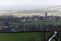
 Chesterblade, view from the churchyard - geograph.org.uk - 1317780.jpg 480 × 640; 107 KB
-
 Chestnut Lane - geograph.org.uk - 6209168.jpg 3,296 × 2,472; 3.41 MB
-
 Closed gates of the creamery - geograph.org.uk - 6214675.jpg 3,296 × 2,472; 3.46 MB
-
 Coronation seat - geograph.org.uk - 6209644.jpg 3,296 × 2,472; 3.53 MB
-
 Cottages in Orchard Lane - geograph.org.uk - 446437.jpg 640 × 486; 145 KB
-
 Cricket on the Recreational Field - geograph.org.uk - 447006.jpg 640 × 480; 96 KB
-

-
 Cyclists at entrance to Small Down Farm - geograph.org.uk - 3921541.jpg 640 × 427; 142 KB
-
 Cyclists riding up Small Down Lane - geograph.org.uk - 3922581.jpg 467 × 640; 153 KB
-

-
 Defibrillator on the village hall - geograph.org.uk - 6209148.jpg 2,472 × 3,296; 3.33 MB
-

-

-

-

-

-
 Direction Sign - Signpost on the B3081 at Evercreech - geograph.org.uk - 6098681.jpg 1,721 × 1,206; 226 KB
-
 Disconnected on Prestleigh Road - geograph.org.uk - 6209150.jpg 2,472 × 3,296; 3.38 MB
-

-

-
 Elizabethan memorial - geograph.org.uk - 6209585.jpg 3,296 × 2,472; 3.61 MB
-

-
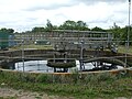
 Evercreech and Stoney Stratton sewage pumping station - geograph.org.uk - 6209592.jpg 3,296 × 2,472; 3.44 MB
-
 Evercreech cemetery - geograph.org.uk - 6209602.jpg 3,296 × 2,472; 3.4 MB
-
 Evercreech cemetery - geograph.org.uk - 6209607.jpg 3,296 × 2,472; 3.5 MB
-
 Evercreech cemetery - geograph.org.uk - 6209609.jpg 3,296 × 2,472; 3.48 MB
-
 Evercreech Co-op - geograph.org.uk - 446420.jpg 640 × 480; 103 KB
-
 Evercreech cricket ground - geograph.org.uk - 6209159.jpg 3,296 × 2,472; 3.58 MB
-
 Evercreech cross and church - geograph.org.uk - 6214860.jpg 2,472 × 3,296; 3.35 MB
-
 Evercreech Fitness Trail - geograph.org.uk - 6209656.jpg 3,296 × 2,472; 3.48 MB
-
 Evercreech Ford - geograph.org.uk - 4873652.jpg 1,600 × 1,067; 1.73 MB
-
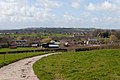
 Evercreech from a hill to the south - geograph.org.uk - 6185660.jpg 3,296 × 2,472; 3.4 MB
-
 Evercreech High Street - geograph.org.uk - 6147480.jpg 4,816 × 3,210; 4.33 MB
-
 Evercreech Jubilee stone - geograph.org.uk - 6209144.jpg 3,296 × 2,472; 3.41 MB
-
 Evercreech Junction - geograph.org.uk - 6091814.jpg 688 × 1,024; 104 KB
-
 Evercreech Market Cross.jpg 640 × 480; 76 KB
-
 Evercreech sewage plant - geograph.org.uk - 6185589.jpg 3,296 × 2,472; 3.61 MB
-
 Evercreech village hall - geograph.org.uk - 6209147.jpg 3,296 × 2,472; 3.39 MB
-
 Evercreech, St. Peter's Church, The nave 1 - geograph.org.uk - 6147482.jpg 6,855 × 4,570; 5.03 MB
-
 Evercreech, St. Peter's Church, The nave 2 - geograph.org.uk - 6147483.jpg 6,920 × 4,613; 6.12 MB
-
 Evercreech, village cross - geograph.org.uk - 4584830.jpg 1,024 × 768; 158 KB
-

-
 Farm building at Winterwell Farm - geograph.org.uk - 6175763.jpg 1,024 × 768; 287 KB
-
 Farm track to Southwood Common - geograph.org.uk - 6185649.jpg 2,472 × 3,296; 3.33 MB
-
 Field on Small Down Farm - geograph.org.uk - 3921477.jpg 640 × 427; 99 KB
-
 Field on Small Down Farm - geograph.org.uk - 3921498.jpg 640 × 427; 124 KB
-
 Fields east of Small Down Lane - geograph.org.uk - 3921532.jpg 640 × 427; 139 KB
-
 Footbridge on Southwood Common - geograph.org.uk - 6185653.jpg 2,472 × 3,296; 3.36 MB
-
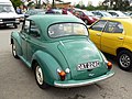
 Footman James 32nd Bristol Classic Car Show 2011 - geograph.org.uk - 2360371.jpg 1,440 × 1,080; 535 KB
-
-
 Footpath to Maesdown Hill - geograph.org.uk - 6209162.jpg 2,472 × 3,296; 3.34 MB
-

-
 Gate and tree - geograph.org.uk - 1311120.jpg 640 × 480; 166 KB
-

-
 Hail storm on Small Down Farm - geograph.org.uk - 3921429.jpg 640 × 427; 85 KB
-
 Hail storm on Small Down Farm - geograph.org.uk - 3921441.jpg 640 × 423; 69 KB
-
 Hail storm over Evercreech - geograph.org.uk - 3921463.jpg 640 × 427; 100 KB
-
 Heading west through Evercreech - geograph.org.uk - 2996134.jpg 640 × 480; 146 KB
-
 High Street, Stoney Stratton - geograph.org.uk - 1311104.jpg 640 × 480; 163 KB
-
 Hoping for the nod - geograph.org.uk - 3898345.jpg 2,304 × 1,704; 1.55 MB
-

-
 Houses opposite Southwood Farm - geograph.org.uk - 5530935.jpg 640 × 370; 48 KB
-
 It used to be lovely here - geograph.org.uk - 6185610.jpg 3,296 × 2,472; 3.51 MB
-

-
 Lane junction and gate - geograph.org.uk - 2504218.jpg 640 × 480; 132 KB
-

-
 Lane out of Chesterblade, heading west - geograph.org.uk - 1311153.jpg 640 × 480; 167 KB
-
 Lane to Chesterfield - geograph.org.uk - 1311130.jpg 640 × 480; 167 KB
-
 Looking southeast along the High Street (B3081) - geograph.org.uk - 4937338.jpg 3,264 × 2,448; 1.95 MB
-
 Lower Bagborough Cottages - geograph.org.uk - 1272330.jpg 640 × 428; 95 KB
-
 Lower Bagborough Farm and Buildings - geograph.org.uk - 1272308.jpg 640 × 428; 91 KB
-
 Machinery at Southwood Common Farm - geograph.org.uk - 6185647.jpg 3,296 × 2,472; 3.35 MB
-
 Machinery near Rodmore Farm - geograph.org.uk - 6185658.jpg 3,296 × 2,472; 3.54 MB
-
 Maesdown Hill, looking north - geograph.org.uk - 5773268.jpg 640 × 480; 91 KB
-
-
 Main road through Evercreech - geograph.org.uk - 2065587.jpg 640 × 480; 155 KB
-

-

-
 Mors janua vitae - geograph.org.uk - 6209603.jpg 3,296 × 2,472; 3.5 MB
-
 Natterjack Inn, Evercreech Junction - geograph.org.uk - 2104503.jpg 640 × 480; 156 KB
-
 New build on Neale's Way - geograph.org.uk - 6209155.jpg 3,296 × 2,472; 3.39 MB
-
 No dogs on the playing fields^ - geograph.org.uk - 6209652.jpg 2,472 × 3,296; 3.21 MB
-
 No more twaddle^ - geograph.org.uk - 6209639.jpg 3,296 × 2,472; 3.41 MB
-
 North side of St Peter's tower - geograph.org.uk - 6214709.jpg 2,472 × 3,296; 3.39 MB
-

-

-

-

-

-

-
 Old Milepost by the A371, Pecking Mill Gate, Evercreech parish (geograph 6049334).jpg 1,396 × 1,704; 460 KB
-
 Ordnance Survey Cut Mark - geograph.org.uk - 3377550.jpg 4,000 × 3,000; 4.93 MB
-
 Outbuildings in Neale's Way - geograph.org.uk - 6214695.jpg 3,296 × 2,472; 3.63 MB
-
 Over a century of milk - geograph.org.uk - 6214693.jpg 3,296 × 2,472; 3.46 MB
-
 Overlooking Milton Clevedon and Lamyatt - geograph.org.uk - 6185665.jpg 3,296 × 2,472; 3.58 MB
-
 Passing Pecking Mill - geograph.org.uk - 5530959.jpg 640 × 471; 62 KB
-
-
 Poppies in the waste - geograph.org.uk - 6186281.jpg 3,296 × 2,472; 3.24 MB
-
 Postbox, Chesterblade - geograph.org.uk - 2280601.jpg 480 × 640; 103 KB
-
 Private road to Small Down Farm - geograph.org.uk - 3921506.jpg 640 × 427; 116 KB
-

-
 Restricted Byway to Cutterne Mill Farm - geograph.org.uk - 6186271.jpg 3,296 × 2,472; 3.47 MB
-
 Right by the sheep pens - geograph.org.uk - 3898332.jpg 2,304 × 1,704; 1.34 MB
-
 Road-ent - geograph.org.uk - 6209619.jpg 3,296 × 2,472; 3.43 MB
-
 Royal Bath and West Showground - geograph.org.uk - 6155096.jpg 4,032 × 3,024; 4.48 MB
-
 Showground entrance - geograph.org.uk - 1272359.jpg 640 × 428; 93 KB
-
 Sign for the Bell Inn - geograph.org.uk - 2280800.jpg 493 × 640; 111 KB
-
 Small Down Cottages - geograph.org.uk - 3921516.jpg 640 × 427; 161 KB
-
 Small Down Farm - geograph.org.uk - 3921488.jpg 640 × 427; 98 KB
-
 Small Down Farm in stormy weather - geograph.org.uk - 3921503.jpg 640 × 427; 113 KB
-
 Small Down hill fort - geograph.org.uk - 3922672.jpg 640 × 427; 114 KB
-
 Small Down hill fort - geograph.org.uk - 3922677.jpg 640 × 427; 139 KB
-
 Small Down hill fort - geograph.org.uk - 3922683.jpg 640 × 427; 119 KB


_-_geograph.org.uk_-_4937338.jpg)


.jpg)
.jpg)


