Category:Falmouth, Virginia
| Object location | | View all coordinates using: OpenStreetMap |
|---|
unincorporated community in Stafford, Virginia   | |||||
| Upload media | |||||
| Instance of | |||||
|---|---|---|---|---|---|
| Location | Stafford County, Virginia | ||||
| Population |
| ||||
| Area |
| ||||
| Elevation above sea level |
| ||||
 | |||||
English: Falmouth is an unincorporated census-designated place in Stafford County, Virginia, United States.
Subcategories
This category has the following 5 subcategories, out of 5 total.
Media in category "Falmouth, Virginia"
The following 37 files are in this category, out of 37 total.
-

-

-

-

-
-

-
-

-

-

-

-

-

-
-

-

-
 AlfredPleasonton.jpg 1,250 × 1,340; 787 KB
-
 Belmont, Falmouth, Stafford County, Virginia. LOC 7535999498.jpg 1,024 × 837; 121 KB
-

-
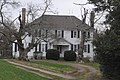 CARLTON, FALMOUTH, STAFFORD COUNTY, VA.jpg 2,784 × 1,848; 896 KB
-
 CLEARVIEW, FALMOUTH, STAFFORD COUNTY.jpg 2,694 × 1,764; 971 KB
-
 Col. Sharpe's horses, Falmouth, Va., April, 1863 LCCN2012649225.jpg 7,837 × 5,972; 3.77 MB
-
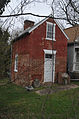
 CONROY HOUSE, FALMOUTH, STAFFORD COUNTY.jpg 2,784 × 1,848; 509 KB
-
 Custer4.jpg 1,024 × 827; 107 KB
-
 FALMOUTH HISTORIC DISTRICT, STAFFORD COUNTY.jpg 1,848 × 2,784; 695 KB
-
 FALMOUTH HISTORIC DISTRICT.jpg 2,784 × 1,848; 604 KB
-
 Falmouth, Virginia as seen from Belmont house.jpg 3,264 × 2,448; 2.3 MB
-
 Horse on the road to Falmouth LCCN2004661137.jpg 5,352 × 3,439; 2.59 MB
-

-

-

-
 Street in Falmouth, Va. LCCN2004660742.jpg 5,352 × 3,417; 2.36 MB
-

-

-
-
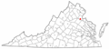 VAMap-doton-Falmouth.PNG 300 × 134; 9 KB
-
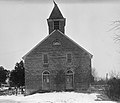
 White Oak Church (Virginia).jpg 769 × 828; 233 KB
.jpg)
_crossing_the_Rappahannock_River_from_Falmouth,_Stafford_County,_Virginia_to_Fredericksburg,_Virginia.jpg)
.jpg)
_crossing_the_Rappahannock_River_from_Falmouth,_Stafford_County,_Virginia_to_Fredericksburg,_Virginia.jpg)
_at_Forbes_Street_(Virginia_State_Secondary_Route_627)_in_Falmouth,_Stafford_County,_Virginia.jpg)
_at_Carter_Street_in_Falmouth,_Stafford_County,_Virginia.jpg)
.jpg)
_crossing_the_Rappahannock_River_from_Falmouth,_Stafford_County,_Virginia_to_Fredericksburg,_Virginia.jpg)
_at_King_Street_in_Falmouth,_Stafford_County,_Virginia.jpg)
_at_Carter_Street_in_Falmouth,_Stafford_County,_Virginia.jpg)

_at_U.S._Route_1_(Jefferson_Davis_Highway)_and_Virginia_State_Route_218_(Butler_Road)_in_Falmouth,_Stafford_County,_Virginia.jpg)
_at_Edison_Lane_in_Falmouth,_Stafford_County,_Virginia.jpg)
_at_Edison_Lane_in_Falmouth,_Stafford_County,_Virginia.jpg)
_at_Carter_Street_in_Falmouth,_Stafford_County,_Virginia.jpg)
_at_Carter_Street_in_Falmouth,_Stafford_County,_Virginia.jpg)


._Camp_1st_U.S.S.S._Lt._Col._Caspar_Trepp,_comdg._Camp_2d._U.S.S.S._Maj._Homer_R._Staughton_comdg._Hiram_Berdan,_col._comdg_3d_brig._3d._(5552635685).jpg)


_(14589483440).jpg)
_(14759548731).jpg)
,_Carter_Street,_Falmouth_(Stafford_County,_Virginia).jpg)

.jpg)