Category:Farmhouse in Speicher, Birtweg 2
| Object location | | View all coordinates using: OpenStreetMap |
|---|
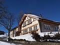
building in Speicher in the canton of Appenzell Ausserrhoden, Switzerland  | |||||
| Upload media | |||||
| Instance of | |||||
|---|---|---|---|---|---|
| Part of | |||||
| Location |
| ||||
| Street address |
| ||||
| Heritage designation | |||||
 | |||||
Media in category "Farmhouse in Speicher, Birtweg 2"
The following 2 files are in this category, out of 2 total.
-
 Bauernhaus Birtweg 2 9042 Speicher AR.jpg 5,184 × 3,888; 9.75 MB
-
 Bauernhaus Birtweg 2 Speicher.jpg 3,646 × 2,051; 1.74 MB
