Category:Forest roads in the United States
Subcategories
This category has the following 10 subcategories, out of 10 total.
*
F
R
S
Media in category "Forest roads in the United States"
The following 65 files are in this category, out of 65 total.
-
 1225 in the forest.jpg 6,016 × 4,000; 6.42 MB
-
 1932. Hemlock second growth stand. Raymond, Washington. (38165992946).jpg 908 × 1,293; 179 KB
-
 2009-0619-TunnelofTrees.jpg 3,408 × 2,298; 5.45 MB
-

-

-
 Aeneas Valley WA from Forest Rd 3120.jpg 6,411 × 1,844; 7.55 MB
-
 Appleton Farms.jpg 1,280 × 960; 376 KB
-
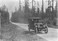
 Automobile on scenic highway in forested area, ca 1925 (PICKETT 215).jpg 768 × 611; 140 KB
-
-
 Butano State Park - Olmo Fire Road.jpg 1,067 × 1,600; 2.18 MB
-
 Costal Redwood.jpg 640 × 853; 99 KB
-
 US 199 Redwood Highway.jpg 2,270 × 3,399; 9.5 MB
-

-

-
 Low-volume roads survey laser (IA CAT10666502).pdf 1,187 × 1,614, 24 pages; 1.27 MB
-
 Chunkwood roads (IA CAT10702498).pdf 1,231 × 1,647, 56 pages; 2.96 MB
-
 The effects of winter haul on low volume forest development roads (IA CAT31066424).pdf 1,212 × 1,625, 56 pages; 3.04 MB
-
 Guidelines for use of fabrics in construction and maintenance of low-volume roads (IA CAT78703655).pdf 1,250 × 1,612, 184 pages; 8.14 MB
-
 National Forest roads for all uses - keeping natural resource quality ; building the right road (IA CAT86864760).pdf 1,179 × 1,577, 24 pages; 2.47 MB
-
 Cathedral Woods, Intervale, White Mountains.jpg 500 × 660; 116 KB
-
 Church Mountain east of Glacier, WA. (33888505452).jpg 901 × 635; 396 KB
-
 County road along the Chetco River in Curry County, Oregon (3424982330).jpg 3,168 × 3,997; 1.27 MB
-

-
 Eagle Mountain (Saguache County, Colorado)-1.JPG 5,241 × 3,109; 11.44 MB
-
 Ellinger Road in wooded Marion Township.jpg 6,016 × 4,000; 6.27 MB
-
 Fall-trees-wv-forest-country-road - West Virginia - ForestWander.jpg 5,616 × 3,744; 13.88 MB
-
 Detroit Photographic Company (0289).jpg 1,160 × 1,536; 545 KB
-
 FOREST ROAD NEAR WEST DOLORES RIVER - NARA - 544860.jpg 2,024 × 3,000; 1.16 MB
-
 Forest road near West Dolores River, 05-1972. (7065691749).jpg 2,024 × 3,000; 639 KB
-
 Forest road standards as related to economics and the environment (IA forestroadstanda145gard).pdf 922 × 1,472, 10 pages; 321 KB
-
 French Trail, Redwood Regional Park.jpg 4,354 × 1,633; 2.56 MB
-
 Glacier Peak 7119.JPG 4,272 × 2,848; 4.15 MB
-

-
 Hapgood Pond - Flickr - USDAgov.jpg 1,500 × 998; 1.46 MB
-
 Heber Snow.JPG 3,264 × 2,448; 3.75 MB
-
 High Trestle Trail in Winter - Night Headlamp - Madrid, Iowa (24196836569).jpg 5,760 × 3,840; 20.35 MB
-
 High Trestle Trail Snow Plow - Madrid, Iowa (24456164262).jpg 4,939 × 3,224; 11.46 MB
-
 Highway 20 in North Cascades (37059142835).jpg 2,048 × 1,536; 1.74 MB
-
 K&Q, Bewdley.jpg 6,016 × 4,000; 6.42 MB
-
 Kentucky Oaks - A Thousand Mile Walk to the Gulf.jpg 2,462 × 1,817; 1.43 MB
-

-
 Loop Road in Ward Township.jpg 6,016 × 4,000; 6.37 MB
-
 Millcreek Road north of Strattanville.jpg 6,016 × 4,000; 6.3 MB
-
 Mineral King Road from Tar Gap Trail.jpeg 520 × 390; 305 KB
-
 Mississippi-80478.jpg 1,920 × 1,280; 2.51 MB
-
 Mount Ouray from Marshall Pass.JPG 6,000 × 4,000; 17.05 MB
-
 MUTCD RS-067.svg 91 × 91; 5 KB
-
 MUTCD RS-095.svg 91 × 91; 6 KB
-
 North end of Diamond Fork Rd, Utah County, Utah, Jul 16.jpg 2,592 × 1,944; 2.37 MB
-
 North on Forest Rd 132, Utah County, Utah, Jul 16.jpg 2,592 × 1,944; 2.41 MB
-
 Ocala National Forest, Ocala, Florida, US.jpg 4,798 × 2,856; 1.93 MB
-
 On the way to the Cave, Forest Highway built by Bureau of Public Roads. - NARA - 298949.jpg 3,000 × 1,713; 1.47 MB
-

-
 Rio Grande National Forest sign.JPG 4,333 × 2,943; 9.85 MB
-
 Santee entrance.jpg 6,016 × 4,000; 6.34 MB
-

-
 Skylinedrive.jpg 1,818 × 1,228; 1.12 MB
-
 Spring - Flickr - minka6.jpg 6,048 × 4,024; 17.27 MB
-
 SR165roadpicture.jpg 2,592 × 1,944; 1.81 MB
-
-
 Sunlight bridge.jpg 1,487 × 1,200; 313 KB
-
 The Pinnacles (Conejos County, Colorado).JPG 5,554 × 3,234; 16.68 MB
-
 Uncompahgre National Forest.JPG 4,520 × 2,847; 12.02 MB
-
 West Fork San Juan River.JPG 3,804 × 5,247; 14.45 MB
-
 Wiley Road near Glass.jpg 6,016 × 4,000; 6.47 MB

.jpg)

.jpg)


.jpg)


.jpg)
.jpg)
_(20639766490).jpg)
-1.JPG)


.jpg)

.jpg)


.jpg)
.jpg)
.jpg)


.jpg)


_(josD0015c).jpg)


.jpeg)

.JPG)


